Local forecast by
"City, St" |
Search by city. Press enter or select the go button to submit request |
|
|
| Choose from the options below for other ways to view your NWS forecast |
|
|

|
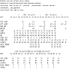
| Current Weather Observations as of
500 PM EDT SAT MAY 09 2009
|
|
|
| Marine Observations as of
507 PM EDT SAT MAY 09 2009
|
| Location |
Wind Direction |
Wind Speed
(kts) |
Air Temperature |
Water Temperature |
| Wrightsville Beach |
SSW
|
16
|
75
|
70
|
| Wilmington Riverfront |
M
|
M
|
M
|
77
|
| Myrtle Beach |
SSW
|
17
|
74
|
74
|
|
|
|

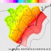
A COLD FRONT WILL DROP SOUTH LATE TONIGHT AND EARLY SUNDAY STALLING
ACROSS THE REGION THROUGH MONDAY. THIS WILL BRING A CHANCE OF
SHOWERS AND THUNDERSTORMS. THE FRONT WILL MOVE SOUTH OF THE AREA
LATE MONDAY...BRINGING COOLER AND DRIER AIR THROUGH MID WEEK...AS
HIGH PRESSURE BUILDS INTO THE REGION FROM THE NORTH. ANOTHER COLD
FRONT WILL APPROACH THE REGION LATE IN THE UPCOMING WEEK.
...see complete discussion.
|
|
|