Get ready for your visit to the
Rocky Mountain Region's (R2) national forests and national grasslands by checking
out our detailed maps, brochures, and information guides.
Each Visitor Map covers all or a portion of one national forest or national grassland, the US Forest Service does not print Visitor Maps outside of national forest or national grassland boundaries. Most of our Visitor Maps are available in a water-proof plastic weave for $10 and/or paper for $9 (prices vary by location). When older version maps are scheduled for reprint, the new maps will only be available in the plastic version. The maps are printed in a scale of 1:126,720, with 1/2 inch per mile, although some maps use a scale of 1 inch per mile. The Visitor Maps show property boundaries (to view changes in lands ownership of national forests lands in the Rocky Mountain Region, click HERE), roads, trails, streams, lakes, recreation sites (such as campgrounds, picnic sites, etc.), land ownership, major points of interest and designated wilderness areas. The US Forest Service also offers statewide wilderness maps for Colorado and Wyoming,
showing all the Congressionally-designated wilderness areas within
each state for $3 each.
Travel Management prescriptions for motorized recreation, current at the time of each Visitor Map's printing, are displayed on each Visitor Map. For more detailed motorized recreation information, the public is strongly encouraged to view the most current Motor Vehicle Use Maps (MVUM). These maps are available on-line by clicking HERE or visiting the closest Ranger District to the area you are interested in.
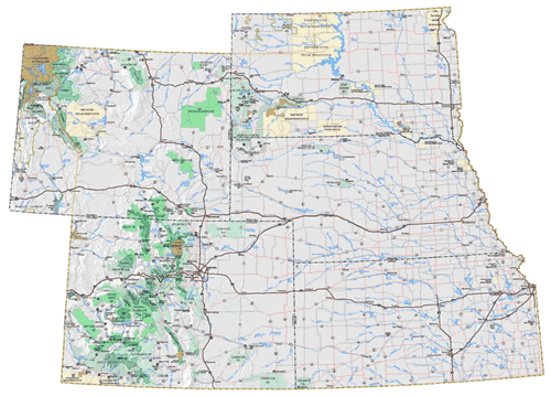
To View R2 National Forest and National Grassland Visitor Maps
Now you can view all of the Rocky Mountain Region's national forest and national grassland Visitor Maps on-line prior to purchasing them! Click on the drop down menu or a state map below to be taken to that state's Visitor Map page. Once you are on the state's Visitor Map page, you will be able to view all of the national forests and national grasslands within that state. Click on the national forest or national grassland you are interested in and a window will appear showing all the options available for that forest or grassland's Visitor Map.
|
Rocky Mountain Region Map |
|
|
| |
Rocky Mountain Region Map |
|
|
|
|
![[design image slice] U.S. Department of Agriculture Forest Service on faded trees in medium light green background](https://webarchive.library.unt.edu/eot2008/20090510150431im_/http://www.fs.fed.us/r2/local-resources/images/rmt-trees-left-usfs.gif)