|
|
|
Metadata
|
|
ID
|
06012
|
|
Also Known As
|
06012
M-1-06-MA
|
|
Abstract
|
United States Geological Survey, Woods Hole, Massachusetts.
Chief Scientist: Walter Barnhardt Tony Wilbur, Massachusetts
CZM. Data (Swath bathymetry, Seismic reflection, Sidescan
sonar) of field activity 06012 (M-1-06-MA) in South Shore,
Hull to Duxbury, Massachusetts, United States, from
08/01/2006 to 08/24/2006
|
|
Organization
|
United States Geological Survey, Woods Hole, Massachusetts
|
|
Project/Theme
|
High-resolution geologic mapping of MA inner shelf
Coastal Change Hazards
|
|
Chief Scientist
|
Walter Barnhardt Tony Wilbur
|
|
Platform
|
Megan T. Miller
|
|
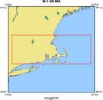
Area of Operation
|
South Shore, Hull to Duxbury, Massachusetts, United States,
|
|
Location map
|
|
|
Bounding Coordinates
|
42.33333
-70.91667 -70.30000
41.91667
|
|
Ports
|
AUG 1, 2006 - Woods Hole, MA
AUG 24, 2006 - Woods Hole, MA
|
|
Dates
|
08/01/2006 (JD 213) to 08/24/2006 (JD 236)
|
|
Analog Materials
|
No analog holdings.
|
|
Index map

|
|
|
Information Specialist
|
|
|
Crew
|
|
Tony Wilbur
|
Massachusetts CZM, Chief Scientist
|
|
Bill Danforth
|
Leg 1 (01-13Aug)
|
|
E.Bergeron
|
Leg 1 (01-13Aug)
|
|
Walter Barnhardt
|
Leg 1 (01-13Aug)
|
|
W. Baldwin
|
Leg 1 (01-13Aug)
|
|
M. Hanshawt
|
Leg 1 (01-13Aug)
|
|
E. Pendleton
|
Leg 1 (01-13Aug)
|
|
D. Foster
|
Leg 2 (13-24Aug)
|
|
C. Worley
|
Leg 2 (13-24Aug)
|
|
T. OBrien
|
Leg 2 (13-24Aug)
|
|
S. Ackerman
|
Leg 2 (13-24Aug)
|
|
E. Himmelstoss
|
Leg 2 (13-24Aug)
|
|
S. Baldwin
|
RTK-GPS
|
|
B. Irwin
|
setup
|
|
|
Equipment Used
|
|
Swath bathymetry
|
|
Seismic reflection
|
|
Sidescan sonar
|
|
|
Purpose
|
|
Geologic mapping of inner shelf to 1] support management of
|
|
habitat and ocean resources, 2] clarify the post-glacial history
|
|
of sea-level change in the region, and 3] reconstruct coastal
|
|
environments and quantify rates of change over the last few thousand
|
|
years
|
|
|
Information to be Derived
|
|
Sea Floor Map;Bathymetric Maps;
|
|
|
Summary
|
|
We collected 100% coverage of seafloor with bathymetry
|
|
and sidescan-sonar data (total mapped area 277 km2), and
|
|
approximately 2340 km of closely spaced seismic-reflection profiles.
|
|
Cruise focused on nearshore areas in water depths of 5-50 m, mostly
|
|
inside state waters. Intermittent problems with GPS reception
|
|
caused numerous shutdowns, especially during first 10 days of
|
|
cruise. Cause is uncertain but we suspect jamming by radar or other
|
|
external source. Gear snagged many lobster pots, which are VERY
|
|
thick in the survey area. See cruise log for details.
|
|
|
Notes
|
|
RTK-GPS base station
|
|
Related Web Sites: >http://woodshole.er.usgs.gov/project-pages/coastal_mass/
|
|
|
Got Help?
|
For 06012, we would appreciate any information on -- activity type, analog materials, contract, days at sea, dive count, funding, kms of navigation, national plan, NGDC Info, owner, project number, publications, scanned materials, seismic description, station count, station description, submersible, tabulated info.
|
|