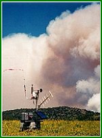
There are nearly 2,200 interagency Remote Automated Weather Stations (RAWS) strategically located throughout the United States. These stations monitor the weather and provide weather data that assists land management agencies with a variety of projects such as monitoring air quality, rating fire danger, and providing information for research applications.
Most of the stations owned by the wildland fire agencies are placed in locations where they can monitor fire danger. RAWS units collect, store, and forward data to a computer system at the National Interagency Fire Center (NIFC) in Boise, Idaho, via the Geostationary Operational Environmental Satellite (GOES). The GOES is operated by the National Oceanic and Atmospheric Administration (NOAA). These data are automatically forwarded to several other computer systems including the Weather Information Management System (WIMS) and the Western Regional Climate Center (WRCC) in Reno, Nevada.
Fire managers use these data to predict fire behavior and monitor fuels; resource managers use the data to monitor environmental conditions. Locations of RAWS stations can be searched online courtesy of the Western Regional Climate Center.
For more information about the interagency RAWS program, contact USFS Program Manager Linnea Keating or BLM Remote Sensing Fire Weather Support Unit Manager Herb Arnold.