Feeds & Data
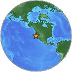
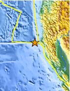
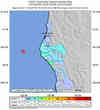
Magnitude 5.2 - OFFSHORE NORTHERN CALIFORNIA
2007 May 09 07:50:05 UTC
Earthquake Details
| Magnitude | 5.2 |
|---|---|
| Date-Time |
|
| Location | 40.376°N, 125.014°W |
| Depth | 9 km (5.6 miles) |
| Region | OFFSHORE NORTHERN CALIFORNIA |
| Distances |
|
| Location Uncertainty | horizontal +/- 0.7 km (0.4 miles); depth +/- 1.7 km (1.1 miles) |
| Parameters | NST=250, Nph=250, Dmin=58 km, Rmss=0.19 sec, Gp=245°, M-type=regional moment magnitude (Mw), Version=3 |
| Source | |
| Event ID | nc51181705 |
- This event has been reviewed by a seismologist.
- Did you feel it? Report shaking and damage at your location. You can also view a map displaying accumulated data from your report and others.