Water Resources of Arkansas
Water Resources of ArkansasWelcome to the USGS Web page that provides access to water resources information for Arkansas; this is your direct link to Arkansas water-resources data--quantity and quality of ground water, quantity and quality of surface water, and water use. You'll also find information about USGS publications and investigations conducted by the USGS and its cooperators. Real-Time Data in Arkansas
Featured Science
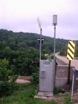
PublicationsValidation of a Ground-Water Flow Model of the Mississippi River Valley Alluvial Aquifer Using Water-Level and Water-Use Data for 1998-2005 and Evaluation of Water-Use Scenarios Jonathan A. Gillip and John B. Czarnecki Summary of Aquifer Test Data for Arkansas-1940-2006 Aaron L. Pugh FS 2008-3103 Floods of Selected Streams in Arkansas, Spring 2008 Jaysson E. Funkhouser and Ken Eng SIR 2008-5193 Occurrence, Distribution, Sources, and Trends of Elevated Chloride Concentrations in the Mississippi River Valley Alluvial Aquifer in Southeastern Arkansas Timothy M. Kresse and Brian R. Clark Water News and NoticesHurricane Ike Raises Flood Concerns (09/12/2008)The year 2008 has so far brought heavy rains, tornadoes....and some of the worst flooding the state has ever seen. Pete Thompson, KARK 4 News New Flood Warning System For Hot Springs (07/28/2008) Officials unveiled a new flood warning information system in Hot Springs, the first in Arkansas to use satellite data transmissions from multiple sites to warn of dangerous conditions. Robert Bell, todaysthv.com Flood Warning Information System Unveiled at Hot Springs (07/22/2008) A flood warning information system has been unveiled at Whittington City Park in Hot Springs. KARK, arkansasmatters.com USGS, Central Arkansas Water, and UALR join in watershed partnership ( 07/03/2008 ) They'll call it the Central Arkansas Watershed Center for Excellence, a new partnership between Central Arkansas Water, the United States Geological Survey and UALR. Mike Duncan, todaysthv.com |

![]() U.S. Department of the Interior |
U.S. Geological Survey
U.S. Department of the Interior |
U.S. Geological Survey
URL: http://ar.water.usgs.gov/index.html
Page Contact Information:
GS-W-AR_webmaster@usgs.gov
Page Last Modified: Tuesday, 06-Jan-2009 14:30:09 CST btj