
 Feeds & Data
ShakeMaps
ShakeMap is a product of the U.S. Geological Survey Earthquake Hazards Program in conjunction with regional seismic network operators. ShakeMap sites provide near-real-time maps of ground motion and shaking intensity following significant earthquakes. These maps are used by federal, state, and local organizations, both public and private, for post-earthquake response and recovery, public and scientific information, as well as for preparedness exercises and disaster planning.
Networks producing ShakeMaps
Click a network name to view a list of events, or on an image to view the event
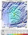
S California

10403777N California

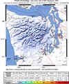
51220943Pacific NW
03300706Nevada

2009092_280079Utah

1000001268Hawaii
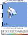
00033691Alaska
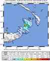
103509Global
2009ggcd
Last 10 ShakeMaps from any Network
A list of all ShakeMaps is available in the ShakeMap Archive
| Mag | Name/Epicenter | Date | Time | Lat | Lon | Network | Event ID |
|---|---|---|---|---|---|---|---|
| 5.2 | NEW BRITAIN REGION, PAPUA NEW GUINEA | May 05 2009 | 22:26:07 UTC | -4.787 | 151.782 | Global | 2009ggcd |
| 3.8 | 24.7 miles E of Talkeetna | May 05 2009 | 21:31:18 UTC | 62.250 | -149.351 | Alaska | 103509 |
| 3.9 | 41.4 miles WNW of Homer | May 04 2009 | 11:46:42 UTC | 59.779 | -152.698 | Alaska | 103270 |
| 5.5 | PAPUA, INDONESIA | May 04 2009 | 03:33:51 UTC | -3.553 | 135.516 | Global | 2009gfad |
| 4.2 | 0.5 km (0.3 mi) NE of Pine Hills, CA | May 03 2009 | 17:54:05 UTC | 40.745 | -124.158 | N California | 51220943 |
| 6.2 | GUATEMALA | May 03 2009 | 16:21:47 UTC | 14.585 | -91.149 | Global | 2009geat |
| 3.6 | 91.5 miles SSW of Kodiak | May 02 2009 | 21:50:46 UTC | 56.648 | -153.650 | Alaska | 103144 |
| 3.6 | 50.1 miles SE of King Cove | May 02 2009 | 02:28:35 UTC | 54.504 | -161.493 | Alaska | 103046 |
| 5.3 | 50.8 miles SE of King Cove | May 02 2009 | 02:19:11 UTC | 54.475 | -161.527 | Alaska | 103035 |
| 4.4 | 3.6 mi ENE of Leo Carrillo State Beach, CA | May 02 2009 | 01:11:13 UTC | 34.069 | -118.882 | S California | 10403777 |
