|
|
|
|
Introduction
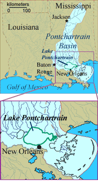
Over the past 60 years, rapid growth and development within the basin, along with natural processes, have resulted in significant environmental degradation and loss of critical habitat in and around Lake Pontchartrain. Human activities associated with pollutant discharge and surface drainage have greatly affected the water quality in the lake. This change is evident in the bottom sediments, which record the historic health of the lake. Also, land-altering activities such as logging, dredging, and flood control in and around the lake, lead to shoreline erosion and loss of wetlands.The effects of pollution, shoreline erosion and wetland loss on the lake and surrounding areas have become a major public concern. To better understand the basin's origin and the processes driving its development and degradation requires a wide-ranging study involving many organizations and personnel. When the U.S. Geological Survey began the study of Lake Pontchartrain in 1994, information on four topics was needed:
|
Related Links: Coastal Research Laboratory Lake Pontchartrain Basin Foundation |