a. Synoptic History
A slow-moving tropical wave led to the formation of Irwin. This wave crossed
over Central America and eastern Mexico on 1-3 October, and spawned Tropical
Depression Eleven over the southwest Gulf of Mexico on 4 October. The
southern portion of the wave produced an area of disturbed weather that
became prominent over the Pacific waters in the vicinity of Acapulco, Mexico
early on 5 October. This weather area was first classified using the Dvorak
satellite technique at 2345 UTC that day. However, for the next couple of
days, the system was strongly sheared from the east and therefore lacked
enough organized deep convection to be classified as a tropical depression.
Early on 8 October, however, deep convection became better organized around a
low-level center, and it is estimated that Tropical Depression Fourteen-E
developed at 1200 UTC on the 8th, about 125 n mi south-southwest of
Manzanillo, Mexico. Images from the Mexican Meteorological Service radar at
Cuyutlan also confirmed the formation of the tropical cyclone.
Initially the cyclone moved slowly north-northwestward, and it strengthened
into a tropical storm, Irwin, while centered about 100 miles south-southwest
of Manzanillo later on the 8th. A strong mid-tropospheric ridge
developed over northern Mexico and this feature caused Irwin's track to
gradually bend toward the northwest, away from the coast of mainland Mexico.
However, the center of the storm came within about 75 n mi of the coastline
between Manzanillo and Cabo Corrientes early on the 9th. Later
that day, Irwin turned toward the west-northwest and, in the presence of
moderate east-northeasterly shear, the storm intensified to its peak
strength of 50 knots by 1800 UTC 9 October.
Early on 10 October, the ridge to Irwin's north forced it on a westward
course, and northeasterly shear combined with more stable air began to take
its toll on the tropical cyclone. Later that day, Irwin turned toward the
west-southwest and the center of the weakening cyclone passed over Socorro
Island around 2000 UTC. By this time, essentially all deep convection
associated with Irwin was gone, and it is estimated that the system's winds
diminished below storm strength. The cyclone dissipated early on 11 October
about 350 n mi southwest of Cabo San Lucas.
b. Meteorological Statistics
Table 1 lists the best track positions and intensities of Irwin at six-hourly
intervals. Figure 1 is a display of this track.
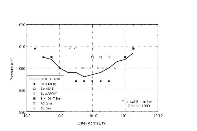
Figure 2 and Figure 3 depict the
curves of maximum one-minute average "surface" (10 meters above ground level)
wind speed and minimum central sea-level pressure, respectively, as a
function of time. Also plotted are the observations on which the curves are
based; these consist of Dvorak-technique estimates from the Tropical Analysis
and Forecast Branch, TAFB, the Satellite Analysis Branch, SAB, and the U.S.
Air Force Weather Agency, AFWA, using satellite imagery.
The maximum intensity estimate for Irwin, 50 knots, is based on a compromise
of Dvorak technique estimates from AFWA, SAB, and TAFB.
There was one ship report of tropical storm force winds associated with
Irwin. At 1800 UTC 9 October, a vessel, with call sign 4QVV, reported
winds 120/45 knots at 18.9 N 105.8 W. This was about 80 n. mi. east of the
center of Irwin at the time.
No strong winds were reported from Socorro Island. Even though the center of
Irwin passed over that location, the cyclone had weakened to a depression,
and apparently strong winds were occurring over a very small portion of the
circulation by that time.
c. Casualty and Damage Statistics
To the author's knowledge, Irwin caused no casualties or damage.
d. Forecast and Warning Critique
Irwin was a tropical storm for only 48 hours, so there are no meaningful
forecast verification statistics. However, it is worth noting that the
official forecasts correctly anticipated that Irwin would not strengthen into
a hurricane.
Since Irwin was initially a threat to the coast, the government of Mexico
issued a tropical storm watch from Punta San Telmo to Cabo Corrientes at 2100
UTC 8 October. This was upgraded to a tropical storm warning for that same
area at 0300 UTC 9 October. The warning was discontinued at 1800 UTC on the
9th, by which time it was clear that Irwin was heading away from
the mainland.

Figure 1.
Best track positions for Tropical Storm Irwin, 8-11 October, 1999.

Figure 2.
Best track maximum sustained (one-minute average) wind speed curve for
Tropical Storm Irwin.

Figure 3.
Best track minimum central pressure curve for Tropical Storm Irwin.
Table 1.
Best track, Tropical Storm Irwin, 8-11 October 1999.
Date/Time
(UTC) |
Position |
Pressure
(mb) |
Wind Speed
(kt) |
Stage |
| Lat. (°N) |
Lon. (°W) |
| 08/1200 | 17.3 | 105.0 | 1005 | 30 | tropical depression |
| 08/1800 | 17.7 | 105.1 | 1004 | 35 | tropical storm |
| 09/0000 | 18.1 | 105.3 | 1000 | 40 | " |
| 09/0600 | 18.4 | 105.7 | 998 | 45 | " |
| 09/1200 | 18.8 | 106.4 | 998 | 45 | " |
| 09/1800 | 19.0 | 107.1 | 996 | 50 | " |
| 10/0000 | 19.1 | 108.0 | 997 | 50 | " |
| 10/0600 | 19.2 | 109.0 | 998 | 45 | " |
| 10/1200 | 19.1 | 110.0 | 1000 | 40 | " |
| 10/1800 | 18.9 | 110.8 | 1003 | 35 | " |
| 11/0000 | 18.4 | 111.3 | 1004 | 30 | tropical depression |
| 11/0600 | 18.0 | 112.0 | 1007 | 25 | " |
| 11/1200 | | dissipated |
| |
| 09/1800 | 19.0 | 107.1 | 996 | 50 | minimum pressure |
![[NCEP Logo]](graphics/ncep.gif)