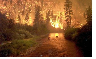
 Elk seek refuge in the East Fork of the Bitterroot River from the Sula Complex Fire, just north of Sula, MT. This fire was just one of thousands in the western U.S. during the second half of the summer of 2000, making it one of the worst fire seasons in recorded history.
Picture taken on Aug. 6, 2000 by John McColgan of the Bureau of Land Management, Alaskan Fire Service. Photo Courtesy of the Alaskan Type I Incident Management Team.
Click HERE for background on how the National Weather Service interacts with other federal agencies in fire suppression and how we prepare and issue Fire Weather Forecasts. Click HERE for a guide on what to expect in regard to specific burning conditions for the five Grassland Fire Danger categories and Red Flag Warning.County Burn Restrictions and/or Bans: South Dakota Minnesota Iowa
Click your area on the map (or use the links immediately below the map)
to view the Fire Weather Narrative Forecast for your area.
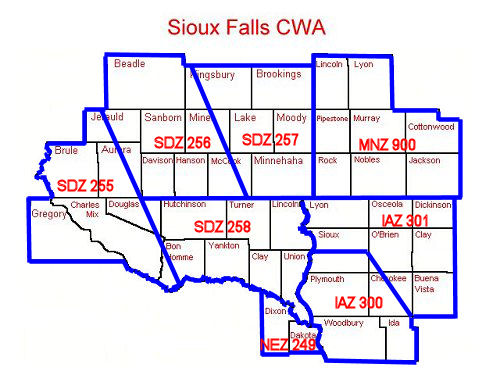
SDZ255 - Lower Brule/Lake Andes [] SDZ256 - Middle James Valley
SDZ257 - Middle Big Sioux Valley [] SDZ258 - Lower James/Lower Big Sioux Valleys
MNZ900 - Southwest Minnesota [] IAZ031 - Iowa Great Lakes/Rock/Little Sioux Basins
IAZ300 - Northern Loess Hills/Floyd Basin [] NEZ249 - Extreme Northeast Nebraska
PRODUCTS FROM NWS SIOUX FALLS(for important specifics on these products, see the explanations section below)
Note: Through interagency agreement, the dates listed above for the Fire Weather Forecast can be altered in times of persistent dry or wet conditions. Interactive Forecast Graphics from Sioux Falls
FIRE WEATHER FROM SURROUNDING NWS OFFICES INCLUDING PLANNING FORECASTS
|
PRODUCTS FROM THE SPC |
DATA
|
LINKS TO AREA FIRE COORDINATION CENTERS
|
NDVI GREENESS DATA FROM THE EROS DATA CENTER AND FUEL MOISTURE
|
USA RAWS CLIMATE ARCHIVE(for current and old RAWS data from any state)
|
ACTIVE FIRE MAPS
|
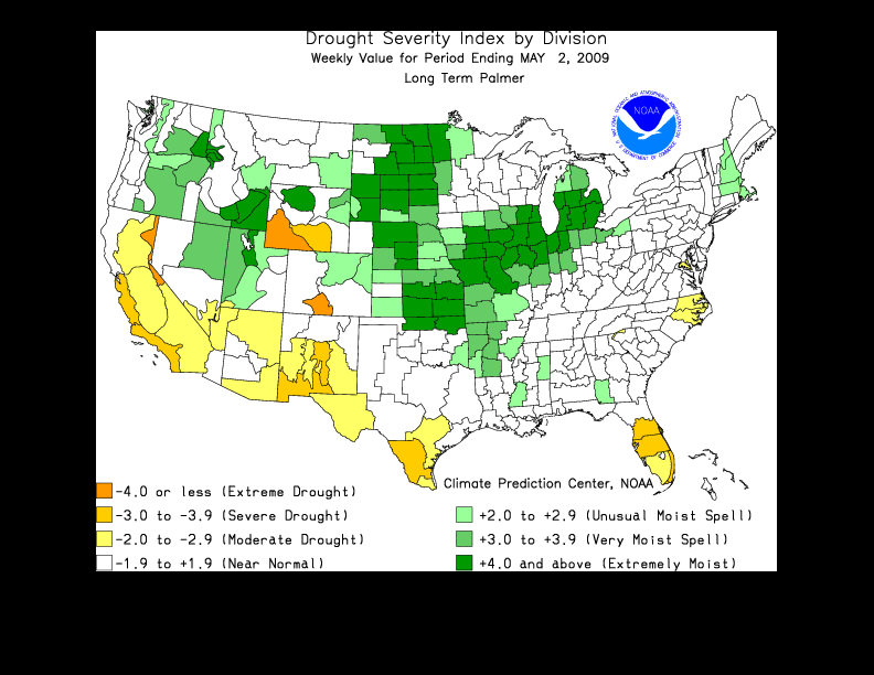
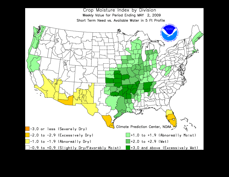
DROUGHT AND HAZARDS ASSESSMENT PRODUCTS(for important specifics on these products, see the explanations section below)
|