...Missouri Summer Safety & Lightning Awareness Week June 22-28...
Missouri Summer & Lightning Safety Week
June 22-28, 2008
Playing it Safe in the Ozarks
Join us in promoting lightning safety during Lightning Safety Week. This page includes important safety information that can save lives. Please help spread the word about Lightning, Flood, UV and Heat safety so we can have a safe summer.
Lightning Safety
|
|
When you are outdoors enjoying the many recreational opportunities in the Ozarks, you should be especially alert for changing weather conditions and know what to do if thunder is heard or lightning is observed. At any given moment, there are 1,800 thunderstorms in progress on Earth. This amounts to 16 million storms a year! In the U.S., there are ~25 million cloud-to-ground lightning flashes each year. While lightning can be fascinating to watch, it is also extremely dangerous. Take a look at outdoor lightning safety rules to know what action to take when lightning is observed or thunder is heard. Tragedies in school sponsored athletics are unfortunately a growing trend as well. When thunderstorms threaten, coaches and officials must not let the desire to start or finish an athletic activity or event cloud their judgment when the safety of participants and spectators is in jeopardy. For more lightning facts and safety information go to the following sites: NWS Lightning Safety Week page
|


|
|

Flood Safety
|
Each year more deaths occur due to flooding than from any other thunderstorm related hazard. Why? The main reason is people underestimate the force and power of water. Many of the deaths occur in automobiles as they are swept downstream. Of these drownings, many are preventable, but too many people continue to drive across a flooded road.
Already this year in the Ozarks, there have been three fatalities and dozens of water rescues due to cars being swept away by flood waters. |
 |
One of the primary flood hazards and causes of flood related deaths across the Ozarks is driving into low water crossings. Every year a few adventurous drivers attempt to cross flooded roads and fail. Whether you are driving or walking, if you come to a flooded road, Turn Around Don’t DrownTM. You will not know the depth of the water nor the condition of the road under the water.
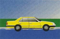
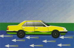
Water weighs 62.4 lbs. per cubic foot and typically flows downstream at 6 to 12 mph. When a vehicle stalls in the water, the water’s momentum is transferred to the car. For each foot the water rises, 500 lbs. of lateral force is applied to the automobile.


But the biggest factor is bouyancy. For each foot the water rises up the side of the car, the car displaces 1500 lbs. of water. In effect, the automobile weighs 1500 lbs. less for each foot the water rises. Two feet of water will carry away most automobiles!!!
UV Safety
|
Outdoor recreational opportunities to enjoy the Summer sun abound in the Ozarks region. However, extended time in sun can be harmful. Before heading to the lake, floating, or to the ball game, make sure to take proper precautions to protect your skin from the harmful effects of ultraviolet rays.
For much more UV information and UV forecast go to the following sites: Environmental Protection Agency UV Information |

| Exposure Category | UV Index | Protective Actions |
|---|---|---|
| Minimal | 0, 1, 2 | Apply skin protection factor (SPF) 15 sun screen. |
| Low | 3, 4 | SPF 15 & protective clothing (hat) |
| Moderate | 5, 6 | SPF 15, protective clothing, and UV-A&B sun glasses. |
| High | 7, 8, 9 | SPF 15, protective clothing, sun glasses and make attempts to avoid the sun between 10am to 4pm. |
| Very High | 10+ | SPF 15, protective clothing, sun glasses and avoid being in the sun between 10am to 4pm. |
UV Safety Tips
|


Heat Safety
|
Summers get hot and humid here in the Ozarks. Although the Ozark Plateau prevents us from reaching temperatures as high as surrounding areas, summer heat can reach dangerous levels, especially when accompanied by humid conditions. This causes the apparent temperature to feel even hotter.
Go to our Heat Index forecast page for expected heat indices. |
Missouri Heat Related Deaths*
Missouri Heat Related Deaths: 1995 - 2006: 337
| Year | 2006 | 2005 | 2004 | 2003 | 2002 | 2001 | 2000 | 1999 | 1998 | 1997 |
| Deaths | 25 | 25 | 3 | 14 | 24 | 47 | 23 | 92 | 12 | 9 |
Heat Index Chart
The combined effects of temperature and humidity can be measured using the Heat Index chart.
|
||||||||||||||||||||||||||||||||||||||||||||||||||||||||||||||||||||||||||||||||||||||||||||||||||||||||||||||||||||||||||||||||||||||||||||||||||||||||||||||||||||||||||
Heat Wave Safety Tips
Drink plenty of water or nonalcoholic fluids. Your body needs water to keep cool. Drink plenty of fluids even if you don’t feel thirsty. Persons who (1) have epilepsy or heart, kidney, or liver disease, (2) are on fluid restrictive diets, or (3) have a problem with fluid retention should consult a physician before increasing their consumption of fluids. Do not take salt tablets unless specified by a physician. Persons on salt restrictive diets should consult a physician before increasing their salt intake. Spend more time in air-conditioned places. Air conditioning in homes and other buildings markedly reduces danger from the heat. If you cannot afford an air conditioner, spending some time each day (during hot weather) in an air conditioned environment affords some protection. Don’t get too much sun. Sunburn makes the job of heat dissipation that much more difficult. |
Slow down. Strenuous activities should be reduced, eliminated, or rescheduled to the coolest time of the day. Individuals at risk should stay in the coolest available place, not necessarily indoors. Dress for summer. Lightweight, light-colored clothing reflects heat and sunlight, and helps your body maintain normal temperatures. Put less fuel on your inner fires. Foods (like proteins) that increase metabolic heat production also increase water loss. Do not drink alcoholic beverages.
|
||||||||||||||||||
Related Links
NWS Springfield Heat Index page: http://www.crh.noaa.gov/sgf/Briefing_Pages/heat_brief.php
NWS Heat Safety: http://www.nws.noaa.gov/om/heat/index.shtml
Missouri Department of Health: http://www.health.state.mo.us
NWS Heat Related Products
To advise you of the potential of excessive heat, NWS Springfield will issue a:
Heat Advisory - Heat Index(HI) of 105 degrees for 3 hours and a minimum 24 hour HI in the middle 70s.
Excessive Heat Warning - HI of 105 degrees for 3 days and a minimum 24 hour HI in the middle 70s. Warnings are also issued for a HI of 115 for 3 hours.
Hazardous Weather Outlook - Daily at 6 AM and 1 PM to highlight the potential of any hazardous weather over the next few days.
Return to News Archive