USGS - science for a changing world

Kansas Water Science Center

Homehome Sudieswater data & studies Research Labresearch lab Pubspublications Floodflood Droughtdrought Contactcontact
Contract All | Expand All
FLOOD WATCH
DATA CENTER
WATER DATA & STUDIES
INFORMATION CENTER
ABOUT KANSAS WSC
USGS IN YOUR STATE

USGS Water Science Centers are located in each state.

There is a USGS Water Science Center office in each State. Washington Oregon California Idaho Nevada Montana Wyoming Utah Colorado Arizona New Mexico North Dakota South Dakota Nebraska Kansas Oklahoma Texas Minnesota Iowa Missouri Arkansas Louisiana Wisconsin Illinois Mississippi Michigan Indiana Ohio Kentucky Tennessee Alabama Pennsylvania West Virginia Georgia Florida Caribbean Alaska Hawaii New York Vermont New Hampshire Maine Massachusetts South Carolina North Carolina Rhode Island Virginia Connecticut New Jersey Maryland-Delaware-D.C.

Photo Gallery of Floods in Kansas, May 2007

May 6, 2007 flood at Smoky Hill River at Ellsworth, KS - highest flow since 1993  Arkansas River near Hutchinson - highest flow since 1993 based on USGS records - May 8, 2007 
Flood gates and levee at Marais des Cygnes River at Ottawa - Highest flow since November 1998  May 10, 2007 flood on Marais des Cygnes River at La Cygne, KS - Highest flow since November 1998 and 7th highest peak on record 
May 25, 2007 flood on Smoky Hill River at New Cambria - Highest flow since gage was established in 1962  Measuring overflow on the Smoky Hill River at New Cambria on May 25, 2007 

USGS Home Water Resources Biology Geography Geology Geospatial
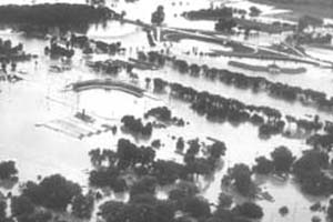
Accessibility FOIA Privacy Policies and Notices

Take Pride in America logo USA.gov logo U.S. Department of the Interior | U.S. Geological Survey
URL: /waterwatch/flood_07/index.html
Page Contact Information: GS-W-KS_info@usgs.gov
Page Last Modified:Wednesday, 17-Sep-2008 13:06:51 CDT