You are at: NWS Home » SRH Home » WFO Key West Home » Marine Page

Welcome to the Florida Keys Marine Web Page

Nowcoast
Tropical Weather
How To Be A Marine Weather Spotter
Southeastern U.S. Marine Weather Portal

If you have any questions about National Weather Service marine weather products and services in the Florida Keys, or if you would like to schedule an office tour or request a speaker, please contact ,Chip Kasper, Marine Program Leader.


Marine Observations
Florida Keys Observations
Pulaski Shoal Light (PLSF1)
Buoy 42080 (4 mi SSW of SANF1)
Sand Key (SANF1)
Sombrero Key (SMKF1)
Long Key (LONF1)
Molasses Reef (MLRF1)
Fowey Rocks (FWYF1)
Plain Language Ship Report
Other Marine Reports
National Data Buoy Center
South Florida Buoy Location Map
QuikSCAT
 

Sea Water Temperatures
Coastal Water Temperatures
 

NOAA/NWS Marine Sites
NOAA Telephone Recordings
Weather Radio Marine Coverage
Product Dissemination Information
Voluntary Observing Ship Program
Mariner's Weather Log
National Ocean Service - NOS
Florida Keys Marine Sanctuary
Harmful Algal Bloom Bulletins
NOAA Teacher at Sea brochure
Marine Weather - Caribbean and Tropical Atlantic
 

Florida Keys Marine Sites
Mote Marine Tropical Research


Weather and Ocean Maps
Surface Analysis - Florida
Surface Map Marine Briefing
Gulf Stream Analysis
Real-Time Ocean Forecast System
NOAA WAVEWATCH III Model


Florida Keys Marine Zones

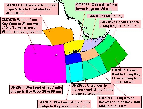
Florida Keys Marine Zones GMZ075: Waters from Key West to 20 nm west of Dry Tortugas north 20 nm and south 60 nm GMZ075: Waters from Key West to 20 nm west of Dry Tortugas north 20 nm and south 60 nm GMZ033: Gulf waters from East Cape Sable to Chokoloskee 20 to 60 nm GMZ032: Gulf side of the lower Keys out 20 nm GMZ032: Gulf side of the lower Keys out 20 nm GMZ033: Gulf waters from East Cape Sable to Chokoloskee 20 to 60 nm GMZ031: Florida Bay GMZ031: Florida Bay GMZ052: Ocean Reef to Craig Key, FL out 20 nm GMZ052: Ocean Reef to Craig Key, FL out 20 nm GMZ053: Craig Key to the west end of the 7 mile bridge out 20 nm GMZ053: Craig Key to the west end of the 7 mile bridge out 20 nm GMZ054: West end of the 7 mile bridge to Key West out 20 nm GMZ054: West end of the 7 mile bridge to Key West out 20 nm GMZ074: West end of the 7 mile bridge to Key West 20 to 60 nm GMZ074: West end of the 7 mile bridge to Key West 20 to 60 nm GMZ073: Craig Key to the west end of the 7 mile bridge 20 to 60 nm GMZ073: Craig Key to the west end of the 7 mile bridge 20 to 60 nm GMZ072: Ocean Reef to Craig Key, FL extending from 20 to 60 nm GMZ072: Ocean Reef to Craig Key, FL extending from 20 to 60 nm

Above is a graphic of the Coastal Marine Zone Forecasts produced by the Key West, FL Forecast Office.
Click on your area of interest for the latest Coastal Waters Forecast.

SYNOPSIS associated with the Florida Keys forecast zones.
COASTAL WATERS FORECAST which includes the synopsis and all the Florida Keys forecast zones.
Latest SPECIAL MARINE WARNING and MARINE WEATHER STATEMENT for theFlorida Keys.
Predicted TIDES and CURRENTS for the Florida Keys.

U.S. Coastal Marine Forecasts
U.S. Coastal Marine Forecasts Text Version


Florida Keys Marine Forecast Discussion
THE DEEP LAYER RIDGE FROM THE SURFACE THROUGH 500MB IS THE MAJOR
PLAYER IN THE MARINE FORECAST. EXPECT THE WINDS TO RELAX A BIT MORE
TODAY AND TONIGHT TO GENTLE TO MODERATE BREEZES ACROSS ALL KEYS
WATERS THROUGH THE WEEKEND. THERE IS A GREATER CHANCE IN THE
ATLANTIC WATERS FOR ISOLATED SHOWERS THROUGH FRIDAY. AFTER FRIDAY
EXPECT CLOUD LINES AND SHOWERS THROUGH BOUNDARY COLLISIONS OFF THE
MAINLAND AND CUBA. OTHERWISE...THE WATERS WILL LAY DOWN MORE THAN
THEY HAVE IN SOMETIME THROUGH THE WEEKEND.


Marine Weather Warning and Forecast Messages
1 Special Marine Warning
1 Costal Hazard Message
2 Marine Weather Statement
2 Marine Weather Message
2 Costal Waters Forecast: Keys | South Florida

Graphical Products
1 Gulf Stream Graphic
1 Daily Forecasts
1 Weekly Forecasts
1 Loops
1 Forecast Elements

Offshore Waters Forecasts
1 SW Atlantic & Caribbean
2 Gulf of Mexico

Marine Reporting
1 Send us your ship reports

NOTICE - Check time and date of forecasts. Linked data may not represent the latest forecast. The Internet is not part of the National Weather Service's operational data stream and should never be relied upon as a means to obtain the latest forecast and warning data. Become familar with and use other means such as NOAA Weather Radio to obtain the latest forecasts and warnings. Please read our DISCLAIMER

Tide Information
Florida Keys Tides
Key West Tide Data Plot
Key West Harbor Tide Plot
Vaca Key Tide Data Plot
Vaca Key Tide Plot
Key West Tide Product
National Tide Information
Current Predictions
 

Boating Safety
Safe Boating Weather Tips
Lightning and Boats
Lightning Protection for Boating
USCG Office of Boating Safety
National Safe Boating Council
South Florida Accident Statistics
 

Marine Weather References
Beaufort Wind Scale
Photos for Determining Wind Speed
VHF Marine Radio Channels
General Marine Definitions
Significant Wave Height or Seas
Map of Florida Keys National Marine Sanctuary
Mariner's Guide to Hurricanes (1.23MB PDF)
Florida Keys Cloud Chart
 

Coral Reef Info
NOAA's Coral Reef Conservation
Reef Relief (located in Key West)
Reef Environmental Education Foundation
 

Astronomical Info
Key West Sunrise and Sunset
Marathon Sunrise and Sunset
Key Largo Sunrise and Sunset
Moon Phases


  • National Weather Service
  • Key West Forecast Office
  • 1315 White Street
  • Key West, FL  33040
  • (305) 295-1316
  • Page Author: NWS Key West
  • Submit Comments/Feedback
  •  
  • Page last modified: 02/03/2009 09:21:02 PM EST
USA.gov is the U.S. government's official web portal to all federal, state and local government web resources and services.