
 Feeds & Data
Magnitude 6.3 - JAVA, INDONESIA
2006 May 26 22:53:58 UTC
Earthquake Details
| Magnitude | 6.3 |
|---|---|
| Date-Time |
= Coordinated Universal Time = local time at epicenter |
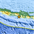
| Location | 7.962°S, 110.458°E |
| Depth | 10 km (6.2 miles) set by location program |
| Region | JAVA, INDONESIA |
| Distances | 20 km (10 miles) SSE of Yogyakarta, Java, Indonesia 110 km (70 miles) S of Semarang, Java, Indonesia 150 km (95 miles) SE of Pekalongan, Java, Indonesia 455 km (285 miles) ESE of JAKARTA, Java, Indonesia |
| Location Uncertainty | horizontal +/- 7.5 km (4.7 miles); depth fixed by location program |
| Parameters | Nst=130, Nph=130, Dmin=220.2 km, Rmss=1.4 sec, Gp= 43°, M-type=teleseismic moment magnitude (Mw), Version=9 |
| Source | USGS NEIC (WDCS-D) |
| Event ID | usneb6 |
- This event has been reviewed by a seismologist.
Did you feel it?
Report shaking and damage at your location. You can also view a map displaying accumulated data from your report and others.
Earthquake Summary

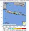
Felt Reports
At least 5,749 people were killed, 38,568 were injured and as many as 600,000 people were displaced in the Bantul-Yogyakarta area. More than 127,000 houses were destroyed and an additional 451,000 were damaged in the area, with the total loss estimated at approximately 3.1 billion US dollars. Felt (IX) at Bantul and Klaten, (VIII) at Sleman and Yogyakarta, (V) at Surakarta, (IV) at Salatiga and Blitar and (II) at Surabaya. Felt in much of Java. Also felt at Denpasar, Bali.
Tectonic Summary
The tectonics of Java are dominated by the subduction of the Australia plate north-northeastward beneath the Sunda plate with a relative velocity of about 6 cm/year. The Australia plate dips north-northeastward from the Java trench, attaining depths of 100-200 km beneath the island of Java, and depths of 600 km north of the island. The earthquake of 26 May 2006 occurred at shallow depth in the overriding Sunda plate well above the dipping Australia plate.
From presently available data, we do not know if there is a direct link between the May 26 earthquake and the ongoing eruption of the volcano Merapi which is several tens of kilometers to the north. The occurrence of shallow-focus earthquakes near volcanoes is not unusual worldwide. Sometimes the association of earthquakes and volcanic eruptions is so close in space and time that it is clear that the earthquakes are triggered by the magmatic processes that are causing the eruption. In the cases of many earthquakes that occur in the general vicinity of volcanoes, however, there are not obvious links to volcanic eruptions. In these cases, the general spatial association of volcanoes and earthquakes is probably due to both seismic and magmatic phenomena being localized by a broader tectonic process.
Earthquake Information for Asia
Earthquake Information for Indonesia
 Tsunami Information
- West Coast & Alaska Tsunami Warning Center
- Pacific Tsunami Warning Center
- Recent Tsunamis
- Tsunami Information Links
The earthquake locations and magnitudes cited in these bulletins are very preliminary, and may disagree with the more accurate USGS locations and magnitudes computed using more extensive data sets.
Earthquake Maps
Earthquake Location
Location Maps
Did You Feel It?
Tell Us

ShakeMap
Historical Seismicity

Seismic Hazard Map

EQ Density Map

Google Map

 Historic Moment Tensor Solutions
- Preliminary Earthquake Report
- U.S. Geological Survey, National Earthquake Information Center
World Data Center for Seismology, Denver
