The National Highway System
To view PDF files, you need the Acrobat® Reader®.
What is the National Highway System?
It is approximately 160,000 miles (256,000 kilometers) of roadway important to the nation's economy, defense, and mobility. The National Highway System (NHS) includes the following subsystems of roadways (note that a specific highway route may be on more than one subsystem):
- Interstate : The Eisenhower Interstate System of highways retains its separate identity within the NHS.
- Other Principal Arterials: These are highways in rural and u
 rban areas which provide access between an arterial and a major port, airport, public transportation facility, or other intermodal transportation facility.
 - Strategic Highway Network(STRAHNET): This is a network of highways which are important to the United States' strategic defense policy and which provide defense access, continuity and emergency capabilities for defense purposes.
- Major Strategic Highway Network Connectors: These are highways which provide access between major military installations and highways which are part of the Strategic Highway Network.
- Intermodal Connectors: These highways provide access between major intermodal facilities and the other four subsystems making up the National Highway System. A listing of all official NHS Intermodal Connectors is available here
The National Highway System (NHS) includes the Interstate Highway System as well as other roads important to the nation's economy, defense, and mobility. The NHS was developed by the Department of Transportation (DOT) in cooperation with the states, local officials, and metropolitan planning organizations (MPOs).
Why a National Highway System?
The 1996 Spring Issue of Public Roads has an article titled The National Highway System: A COMMITMENT TO AMERICA'S FUTURE by the former FHWA Administrator, Rodney Slater. This article gives the basis for the National Highway System.
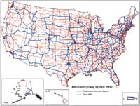
Where is the NHS?
You can view state maps of the National Highway System.
- Select the State below to view the National Highway System maps depicting the designated NHS routes.
- You can also view the NHS in an urbanized area by clicking on the urbanized area name on the state map. Also, clicking on an adjoining State name will open that State map.
- These maps are in Adobe Acrobat's Portable Document Format (PDF). If you are having problems viewing the Urbanized Area Maps, which are linked to the state maps, this solution might help.
NHS Viewer
The hard copy NHS maps are complemented by an electronic version that can be displayed using a web-based mapping application, the NHS Viewer, accessible through a standard web browser, such as Internet Explorer or Netscape Navigator. The NHS viewer allows you to display the NHS at a statewide level as well as zoom into an NHS segment or local area of interest. As you zoom in a more detailed street network will appear in the background providing orientation to the geographic location of the NHS segment of concern.
The web address for the NHS Viewer is http://hepgis.fhwa.dot.gov/hepgis_v2/Highway/Map.aspx
NHS Approval process
NHS Procedures procedures for system actions on the National Highway System.
NHS Update
The primary emphasis of this review is to validate and update the NHS intermodal connectors, verifying connector mileages and connector route descriptions, and adding or deleting connectors as justified. The secondary emphasis is to conduct a general review of the NHS mainline, including examining the STRAHNET. (more)
Interstate Frontage Roads
Interstate Frontage Roads are generally not part of the Interstate or NHS but there are exceptions and other material concerns related to the Interstate Frontage Road issue.
Other Links of Interest
NHS High Priority Corridors designated as Future Interstates
Future Interstate procedures for system actions on the Interstate System.
There are two general procedures for designating future Interstate routes.
Highway Systems - Federal-Aid Policy Guide - policies and procedures relating to the identification of federal-aid highways, functional classification of roads and streets, the designation of urban area boundaries, and the designation of routes on the Federal-aid highway system.
Contact
NHS Designation: Mike Neathery, mike.neathery@dot.gov, 202-366-1257