Oklahoma Water Science Center
Precipitation totals for the 2009 Calender Year are below normal, about 79 percent of normal for the period January 1, 2009 through April 27, 2009, averaged statewide. Rainfall totals are about 7.36 inches, 1.98 inches below normal, averaged statewide for the period, the 27th driest since 1921. There was drought relief the past 30 days with 3.47 inches of precipitation, averaged statewide, the 34th wettest since 1921. Presently the 'driest' climate region is the Southwest, at 61 percent of normal, the 18th driest period since 1921. On the other hand, the 'wettest' climate region is the North Central, the region is at 97 percent of normal, the 35th wettest period since 1921. Updated April 28, 2009.
Precipitation totals for the 2009 Water Year are below normal, at 70 percent of normal for the period October 01, 2008 through April 27, 2009, averaged statewide. Precipitation totals are about 12.21 inches, 5.35 inches below normal, averaged statewide for the period. The 'driest' climate region, the South Central, is at only 48 percent of normal precipitation, 10.98 inches below normal, the 4th driest period since 1921. The 'wettest' climate region, the Panhandle, is at 104 percent of normal precipitation, 0.29 inches above normal, the 26th wettest period since 1921. Updated April 28, 2009.
These data and other aspects of the state moisture situation can be found in the Oklahoma Water Resources Bulletin, "Summary of Current Conditions" (Courtesy of Oklahoma Water Resources Board).
A variety of drought indicators can be used including precipitation, streamflow, ground-water levels, reservoir storage and the Palmer Index.
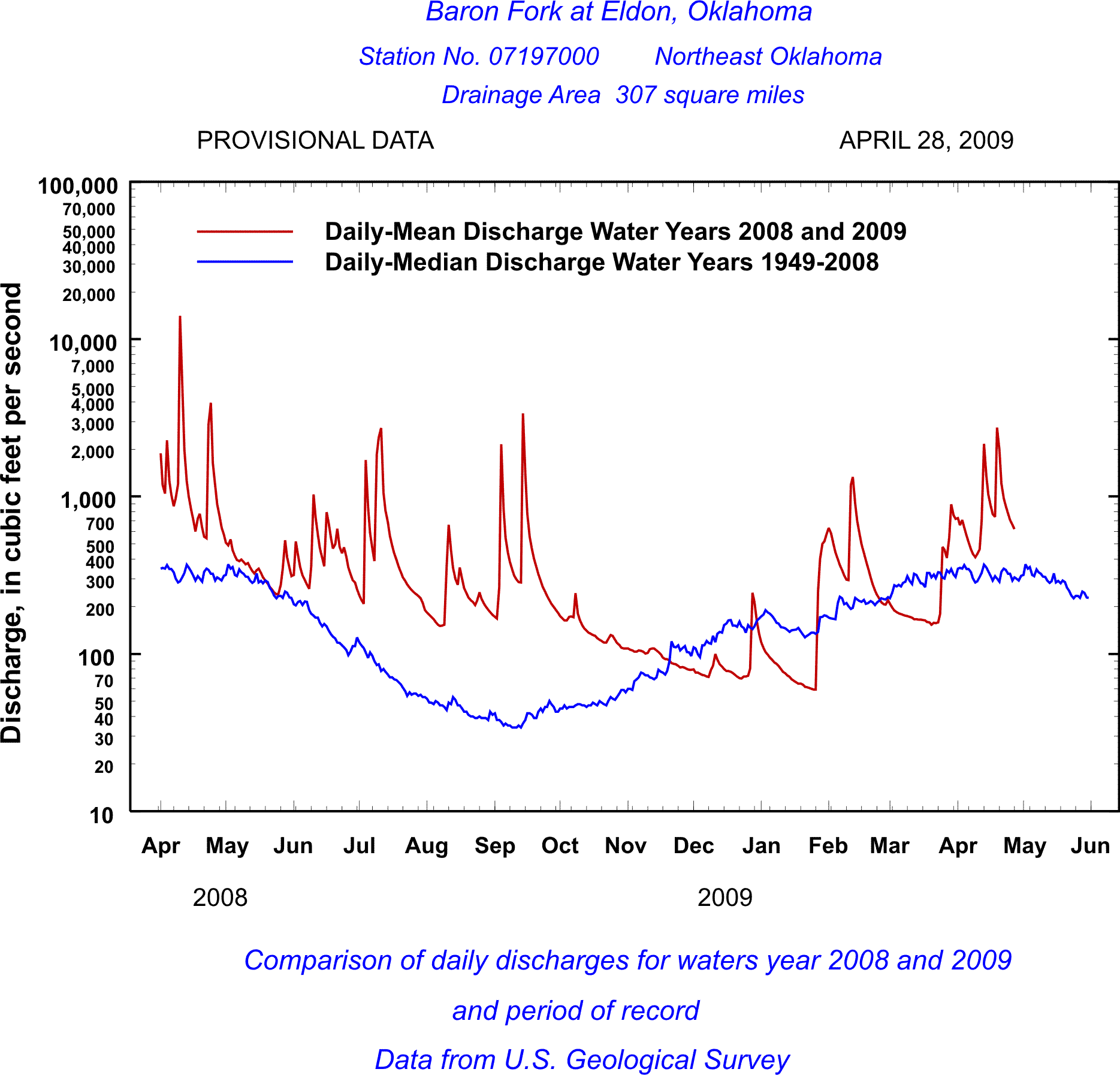
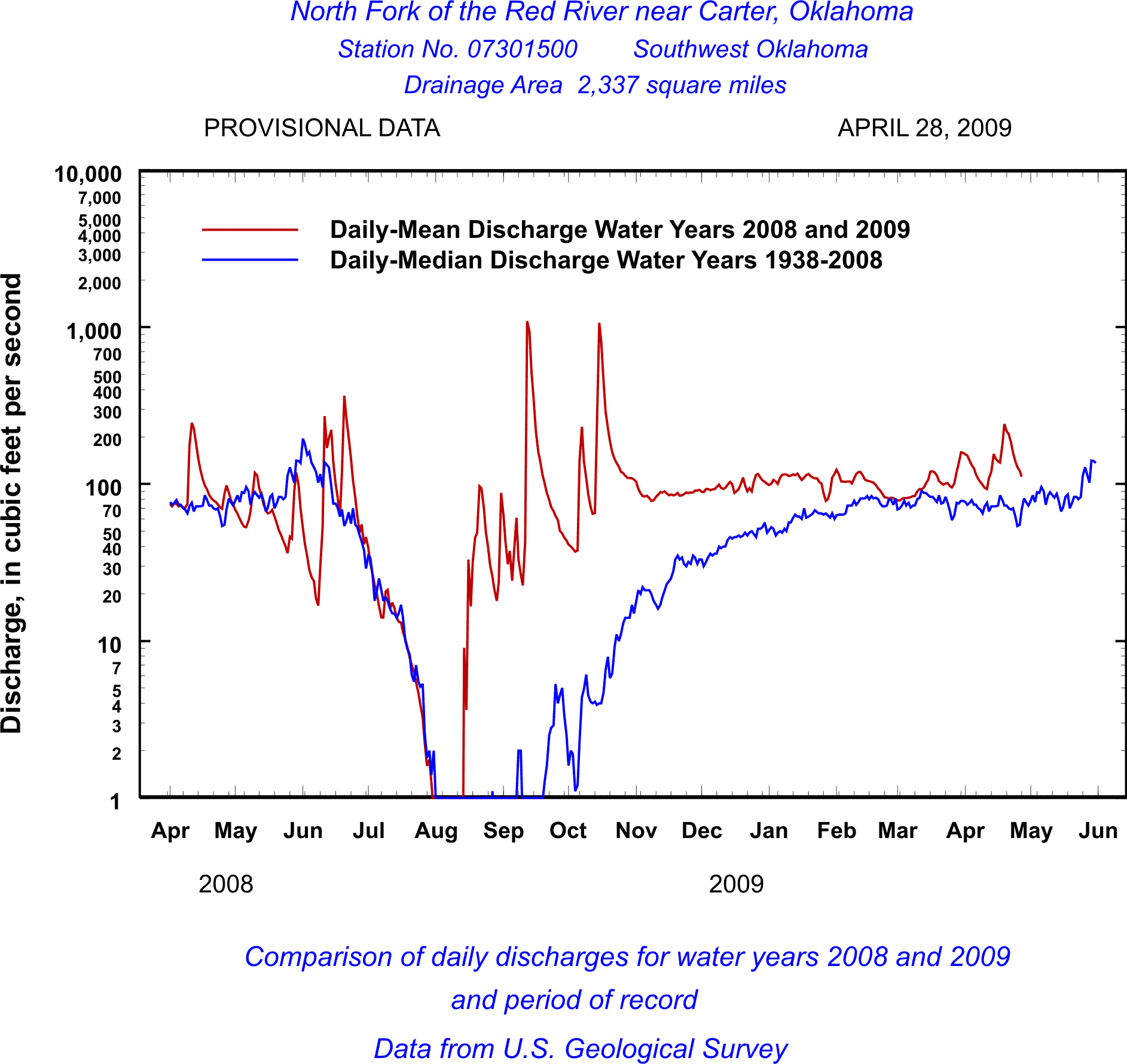
The streamflow plots (hydrographs) at the following six U.S.
Geological Survey streamflow-gaging stations are indicators of the
drought conditions in Oklahoma. The present streamflows are compared with the
median flows of record, which are a good index of the expected streamflow
conditions.

|
|
Included on the NDMC page is a link to the U.S. Drought Monitor which is drought monitoring effort between the NDMC, U.S. Department of Agriculture,and NOAA. Drought Monitor.
The monthly Palmer Drought Severity Index (PDSI) and precipitation for each of the Oklahoma Climatic Divisions can be seen at the National Climatic Data Center climate visualization system, CLIMVIS.
The Oklahoma Climatological Survey at the University of Oklahoma, has Oklahoma Summary Precipitation Statistics and Oklahoma Climatological Data available. Oklahoma Rainfall Update.
The USGS Water Watch Web Page has current water resources
conditions and has a Drought Watch Map available that shows the following
hydrologic drought information for Oklahoma.
Water Watch.
|
MAP OF BELOW NORMAL 7-DAY AVERAGE STREAMFLOW COMPARED TO HISTORICAL STREAMFLOW FOR THE DAY OF THE YEAR | |||||||||||||||||||

|
|
||||||||||||||||||
|
MAP OF BELOW NORMAL 7-DAY AVERAGE STREAMFLOW COMPARED TO HISTORICAL STREAMFLOW FOR THE DAY OF THE YEAR | |||||||||||||||||||
 |
|
||||||||||||||||||
The first "Below Normal Streamflow Map" shows the average streamflow conditions for the past 7 days, highlighting locations in Oklahoma that are experiencing low flows or hydrologic drought.
The second "Below Normal Streamflow Map" shows the 7-day average streamflow conditions in the hydrologic units of Oklahoma for the day of year, highlighting locations that are experiencing low flows or hydrologic drought.
The maps depict 7-day average streamflow conditions as computed at USGS gaging stations. The colors represent 7-day average streamflow compared to percentiles of 7-day average streamflow for the day of the year. The maps represent conditions adjusted for this time of the year. Only stations having at least 30 years of record are used. By averaging over past 7 days, the values on the map are more indicative of longer-term streamflow conditions than either the "Real-time streamflow" or the "Daily streamflow" maps.
During winter months, parts of the state may have fewer dots than at other times of the year due to ice effects.
The data used to produce this map are
provisional and have not been reviewed or edited.
They may be subject to significant change.

![]() U.S. Department of the Interior |
U.S. Geological Survey
U.S. Department of the Interior |
U.S. Geological Survey
URL: http://ok.water.usgs.gov/drought.news.html
Page Contact Information: Webmaster
Page Last Modified: Tuesday, 28-Apr-2009 15:26:38 EDT


