|
Drought Conditions |
|
|
Fast forward to: Local Drought Statement |
|
| Local Drought Statement: | |
|
Drought statements are normally issued for southwestern Iowa, and eastern Nebraska when Severe Drought (D2+) or worse conditions develop over the region and are expected to persist. Currently, these conditions are not observed. |
|
| Latest Drought Monitor Graphics: | |
|
|
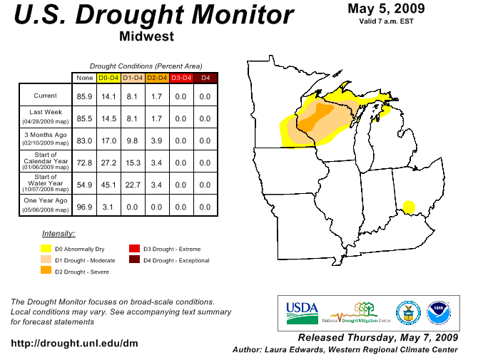
The categories of drought are defined as follows: Abnormally Dry (D0) - Going into drought: short-term dryness slowing planting, growth of crops or pastures; fire risk above average. Coming out of drought: some lingering water deficits; pastures or crops not fully recovered. Moderate Drought (D1) - Some damage to crops, pastures; fire risk high; streams, reservoirs, or wells low, some water shortages developing or imminent, voluntary water use restrictions requested. Severe Drought (D2) - Crop or pasture losses likely; fire risk very high; water shortages common; water restrictions imposed. Extreme Drought (D3) - Major crop/pasture losses; extreme fire danger; widespread water shortages or restrictions. Exceptional Drought (D4) - Exceptional and widespread crop/pasture losses; exceptional fire risk; shortages of water in reservoirs, streams, and wells, creating water emergencies. |
|
The U.S. Drought Monitor is a weekly collaborative effort between a number of federal agencies including NOAA/NWS, U.S. Department of Agriculture, and the National Drought Mitigation Center. Details and explanations of the Drought Monitor can found at the web site: http://www.drought.unl.edu/dm/monitor.html Note: Drought categories are based on broad-scale indicators over "climate districts" (the gray division lines on the U.S. map above). The central Illinois map below it attempts to delineate the drought categories on a smaller scale map. Note that because the categories do not follow county lines, the "transition areas" on the central Illinois map may be larger than indicated above. Also, small-scale factors, such as localized heavy rain from thunderstorms, may affect the drought level over a small area, which may not necessarily be reflected in the maps above. The latest seasonal drought outlook from the Climate Prediction Center at: http://www.cpc.ncep.noaa.gov Specific impacts from the drought are available on the Drought Impact Reporter at: http://droughtreporter.unl.edu |
|
| Soil Moisture: | |
| Additional soil moisture maps are available at the MRCC's Midwest Moisture Daily Update: http://mrcc.sws.uiuc.edu/ cliwatch/drought/moisture.htm and the CPC's Crop Moisture Index page: http://www.cpc.ncep.noaa.gov/ products/analysis_monitoring/ regional_monitoring/cmi.gif For the impact on crop conditions across Illinois, visit the USDA's Illinois Weather and Crop Information page at http://www.nass.usda.gov/il/ For wildfire potential, visit the National Interagency Fire Center's Wildland Fire Assessment System page at: http://http://www.wfas.net/> |
|
| Precipitation: | |
|
|
Additional soil moisture maps are available at the HPRCC’s Current Climate Summary Maps: http://www.hprcc.unl.edu/maps/current/
and the MRCC's Midwest Drought Information:
and the CPC's Daily Precipitation Analysis page: |
| Long Range Outlooks: | |
|
Precipitation forecasts for the next 5 days are available from the Hydrometeorological Prediction Center (HPC) Web Site: For updated temperature and precipitation probabilities consult the following Climate Prediction Center (CPC) Web Sites: 8 to 14 Day Outlook: 30 Day Outlook: 90 Day Outlook: Drought Outlook: |
|
| Acknowledgements and Related Links: | |
|
The drought monitor is a multi-agency effort involving NOAA's National Weather Service and National Climatic Data Center, the USDA, State and Regional Center Climatologists and the National Drought Mitigation Center. Information for the drought statements has been gathered from NWS and FAA observation sites, Iowa State and Illinois Cooperative Extension Services, the USDA, COE and USGS. Local weather, climate and water information - http://weather.gov/omaha Drought Monitor - http://www.drought.unl.edu/dm/ Missouri Department of Natural Resources - http://www.dnr.mo.gov/env/wrc/droughtupdate.htm Additional river information - NOAA Drought Page - http://www.drought.noaa.gov |
|
- National Weather Service
- Omaha/Valley, NE Weather Forecast Office
- 6707 North 288th Street
- Valley, NE 68064-9443
- 402-359-5166
- Page Author: OAX Webmaster
- Web Master's E-mail: w-oax.webmaster@noaa.gov
- Page last modified: October 14th 2008 5:30 PM


