About the Georgia Water Science Center
The Georgia Water Science Center (WSC) is one of 48 Water Science Centers in the Water Resources Discipline of the U.S. Geological Survey (USGS). The Water Science Center's mission is to collect, analyze and disseminate the impartial hydrologic data and information needed to wisely manage water resources for the people of the United States and the State of Georgia.
Office Information
What We Do
 We operate local and statewide networks to collect high-quality data that define natural and human-induced hydrologic conditions.
- We analyze hydrologic processes through investigations and research to increase understanding of important water-resource issues and to promote informed decision making.
- We maintain real-time and historical data bases and publish peer-reviewed interpretive and data reports to disseminate unbiased hydrologic information.
To assure that our work is relevant and useful, we form partnerships with Federal, State, and local agencies, and other public organizations.
Funding for the Georgia Water Science Center comes from a variety of sources, including direct Federal appropriations, other Federal agencies, and a cooperative program that allows the Georgia Water Science Center to partially match funding with state and local agencies. Information concerning USGS products and services can be obtained from:
The Georgia WSC home page provides direct access to current and historical USGS streamflow data, a bibliography of Georgia Water Science Center reports, and much more about USGS operations in the state of Georgia.
Data Collection
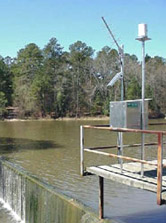
 Basic hydrologic data collection, processing, analysis, dissemination, and archiving are major parts of the Georgia Water Science Center program. Streamflow data, for example, are used for flood and water-supply forecasts, planning and design, river regulation, streamflow statistics, and research investigations. Much of the data are available on a near-real-time basis by satellite telemetry. Types of data currently collected include: Basic hydrologic data collection, processing, analysis, dissemination, and archiving are major parts of the Georgia Water Science Center program. Streamflow data, for example, are used for flood and water-supply forecasts, planning and design, river regulation, streamflow statistics, and research investigations. Much of the data are available on a near-real-time basis by satellite telemetry. Types of data currently collected include:
- Streamflow data for 260 gaging stations
- Continuous ground-water level data at over 190 wells
- Water-quality data for over 100 sites
- Stream-sediment transport data
- Climate data
Database Capabilities
USGS data are stored and maintained in long-term, quality-assured data bases. The data bases contain data for Georgia and the rest of the nation and are accessible to the public. The data include:
- Streamflow, reservoir, and lake data
- Ground-water data
- Continuous and discrete water-quality data
- Water-use data
- Geographic Information System (GIS) data
Projects
 The chief purpose of hydrologic projects is to help cooperating agencies solve water problems. For example, investigative results have been used to manage storm-water runoff, to develop ground-water management plans, and to identify areas of water-quality degradation. These investigations address many water issues: The chief purpose of hydrologic projects is to help cooperating agencies solve water problems. For example, investigative results have been used to manage storm-water runoff, to develop ground-water management plans, and to identify areas of water-quality degradation. These investigations address many water issues:
- Water-quantity and quality assessments
- Toxic substances in natural waters and biota
- Rural and urban nonpoint pollution
- Saltwater intrusion
- Surface-water / ground-water interactions
- Sediment transport and chemistry
- Effects of climate change
- Wetland functions and hydrology
- Aquifer and streamflow characterizations
- Frequency and magnitude of droughts and floods
Analytical Techniques
The Georgia Water Science Center uses state-of-the-art as well as traditional methods that include quality assurance and quality control:

- Watershed modeling
- Flood and low-flow frequency analysis
- Sediment and chemical load determination
- Aquifer testing
- Aquatic testing
- Aquatic community analysis
- Geographic Information Systems (GIS)
- Acoustic doppler velocity measurements
- Ground-water age dating
- Surface and borehole geophysics
- Evapotranspiration analysis
- Ground-water recharge modeling
- Solute-transport modeling
- Geochemical modeling
- Ground-water flow modeling
- Water, sediment, and tissue analysis
Water-quality samples are collected and analyzed for a wide range of constituents, including major inorganics, nutrients, trace elements, dissolved gases, pesticides, isotopes, organic solvents, petrochemicals, and biological indicators.
|