North Dakota Water Science Center
|
Webcam on Red River at Grand Forks, ND 
Information Center
Red River Basin
Devils Lake Basin
Missouri River Basin North Dakota Wetlands Annual Data Reports Lewis & Clark and the USGS Canoeing North Dakota's Rivers Education USGS IN YOUR STATEUSGS Water Science Centers are located in each state. 
|
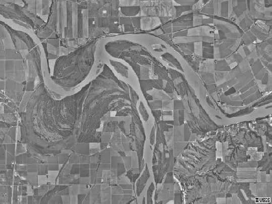
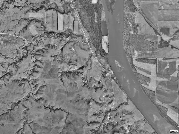
Missouri RiverDescriptionThe Missouri River is regulated in most of its course through North Dakota. Of the 390 miles of river in the State, only the 90-mile reach between Lake Sakakawea and Lake Oahe and a small reach near the Montana border have not been inundated. The reach between Lake Sakakawea and Lake Oahe is, however, controlled by releases from Garrison Dam. While river levels do fluctuate, the river is rarely too low for canoeing. The Missouri River is the largest river in North Dakota. The Missouri River Basin, located in the west half of North Dakota and coinciding approximately with the part of the State having a semiarid climate, is comprised of seven major subbasins and drains about 34,000 square miles or about 48 percent of the State's total area. Garrison Dam, about 70 miles north of Bismarck, was built in 1953 as part of a system of dams and reservoirs located on the Missouri River in Montana, North Dakota, and South Dakota. The U.S. Army Corps of Engineers built the dams, in part, to control flooding on the Missouri River. Before the construction of Garrison Dam, the maximum peak streamflow measured at Bismarck was 500,000 cubic feet per second on April 6, 1952. For 1954-2000, the annual mean flow at Bismarck was 23,170 cubic feet per second. Lake Sakakawea was formed as a result of Garrison Dam and is the largest lake in North Dakota. The reservoir can store about 24.5 million acre-feet of water and has about 1,600 miles of shoreline through six counties. About 20 miles south of Bismarck is the upstream end of Lake Oahe. Lake Oahe was formed as a result of the construction of Oahe Dam near Pierre, South Dakota. For more information on the Missouri River system, visit the U.S. Geological Survey's Missouri River InfoLINK web site at http://infolink.cr.usgs.gov/. Physiographic points of interest along the Missouri River in North Dakota include Yellowstone River, Crow Fly High Hill, Tobacco Garden Bay, White Tail Bay, Red Mike Hill, Sand Creek Bay, Hofflund Bay, Phelps Bay, Sanish Bay, Four Bears Bay, Hunts Along Bay, Reunion Bay, Bear Den Bay, Drags Wolf Bay, Skunk Creek Bay, Van Hook Arm, Shell Creek Bay, Deepwater Creek Bay, Saddle Butte Bay, Arikara Bay, Water Chief Bay, Elbowoods Bay, Medicine Stone Bay, Red Butte Bay, Good Bear Bay, Nishu Bay, Beaver Creek Bay, Renner Bay, Beulah Bay, Expansion Bay, Douglas Creek Bay, Garrison Bay, De Trobriand Bay, Mallard Island, Garrison Dam, Lake Audubon, Knife River, Painted Woods Lake, Square Buttes, Heart River, Twin Buttes, Sugarloaf Butte, Corner Butte, Devils Gulch, Cannonball River, Twin Buttes, Beaver Creek, Winnona Flats, and Lake Pocasse (in South Dakota). Missouri River recreationists also have access to a wide variety of public lands, including Fort Union Trading Post National Historic Site, Fort Buford State Historic Site, Lewis & Clark Wildlife Management Area, Lewis & Clark State Park, Tobacco Garden Creek Wildlife Management Area, Little Missouri National Grasslands, Hofflund Wildlife Management Area, Van Hook Wildlife Management Area, Deep Water Creek Wildlife Management Area, Hille Wildlife Management Area, Douglas Creek Wildlife Management Area, Lake Sakakawea State Park, Fort Stevenson State Park, De Trobriand Wildlife Management Area, Custer Mine Wildlife Management Area, Audubon National Wildlife Refuge, Wolf Creek Wildlife Management Area, Riverdale Wildlife Management Area, Knife River Indian Villages National Historic Site, Fort Clark State Historic Site, Arroda Lake Wildlife Management Area, Cross Ranch State Park, Painted Woods Wildlife Management Area, Double Ditch Indian Village State Historic Site, On-A-Slant Indian Village State Historic Site, Fort Abraham Lincoln State Park, Oahe Wildlife Management Area, and Pocasse National Wildlife Refuge (in South Dakota). These public areas are identified on topographic maps (see Maps page). In addition, there are many public access boat ramps along the Missouri River. Links to some of these places are provided on the Additional Information page. Missouri River Resources
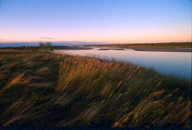
SceneryBelow are images of scenery along the Missouri River. Click on an image to view a larger version. Use your browser's back command to return to this page.
To read what Lewis and Clark said about the Missouri River and its tributaries, click HERE. Canoeing Home | Little Missouri River Home | Recommendations | Maps | More |
||||||||||||||||||||||||||||||

![]() U.S. Department of the Interior |
U.S. Geological Survey
U.S. Department of the Interior |
U.S. Geological Survey
URL: http://nd.water.usgs.gov/canoeing/missouri/index.html
Page Contact Information: Webmaster
Page Last Modified: Monday, 11-Feb-2008 15:52:14 EST
Menlo Park, CA [caww51]