 NCDC / Climate Mon. / Climate-2006 / June / U.S. Drought / Help NCDC / Climate Mon. / Climate-2006 / June / U.S. Drought / Help
Climate of 2006 - June
U.S. Drought Watch
National Climatic Data Center, 13 July 2006
|
Global Analysis /
Global Hazards /
United States /
Extremes
Use these links to access detailed analyses of Global and U.S. data.
|
Contents Of This Report:
|

|

 National Overview National Overview
|
|
|
- A file containing the national monthly percent area severely dry and wet from 1900 to present is available for the severe to extreme and moderate to extreme categories.
- Historical temperature, precipitation, and Palmer drought data from 1895 to present for climate divisions, states, and regions in the contiguous U.S. are available at the Climate Division: Temperature-Precipitation-Drought Data page in files having names that start with "drd964x" and ending with "txt" (without the quotes).
|
Detailed Drought Discussion
|
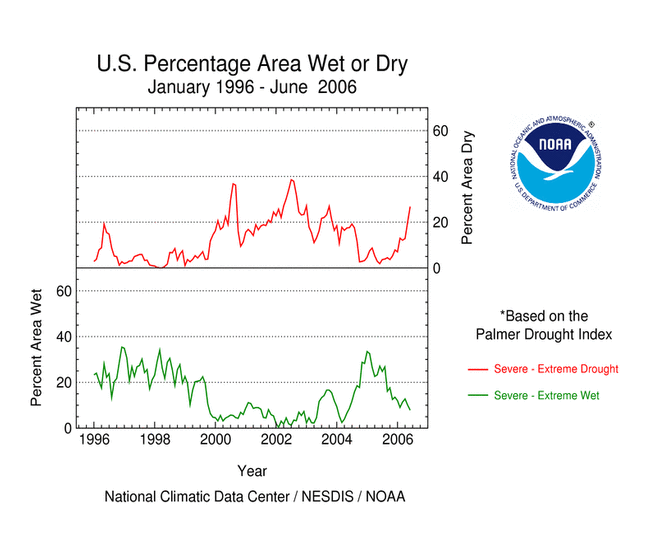
Dryness was observed in June over much of the country west of the Appalachians. The Southwest, western Texas, western High Plains and the south Atlantic states have experienced very dry conditions for the last several months. The most severe conditions at the end of June were in the Desert Southwest and western Plains, and along parts of the western Gulf coast. About 9 percent of the contiguous U.S. was very dry (i.e., precipitation in the bottom 10th percentile of the historical record).
Coupled with the very dry conditions were continuing high temperatures in the Southwest and western Plains. The combination of high temperatures and very little precipitation led to extreme drought as defined by the Palmer Z Index.
Heavy rain near the end of the month in the mid-Atlantic States alleviated dry conditions, but dryness continued in most of the Southeast.
The June precipitation pattern at the primary stations in Alaska was below normal in most of the southeast part of the state. Across Hawaii, the precipitation pattern remained dry in the Northwest and became progressively drier towards the Southeast. In Puerto Rico, the month was predominantly dry in the central and western interior areas and along the northeast coast, based on National Weather Service radar estimates of precipitation.
|
|
Some regional highlights:
- Several states had the tenth driest, or drier, multi-month seasons (April-June, January-June, July-June).
- Month-averaged and end-of-month soil moisture conditions, based on model computations (CPC-1, CPC-2, MRCC), were drier than normal across a broad swath from the Southwest and central Plains to the Atlantic coast. At depth, soil moisture across eastern Nebraska and Kansas continued much below normal.
- Low streamflows, as computed by models and based on USGS observations, continued in the Southeast westward and northward into the Southwest and northern Plains.
|
State/Regional/National Moisture Status
|
Pre-Instrumental Perspective
|
|
June 2006 Paleoclimatic Analysis for Southern Wyoming
|
|
The past year has seen a deepening of the long-term drought conditions that have persisted since late 1999 in southern Wyoming. Since July 2005, precipitation in Wyoming Division 10 (Upper Platte basin) has been below normal in 10 of 12 months, totaling only 73% of normal during the period. Both the Palmer Hydrological Drought Index (PHDI) and Palmer Drought Severity Index (PDSI) for Division 10 have values below -4 for late June 2006, indicating "extreme drought".
|

large image
|
|
The graph below (annual values in light blue, 5-year weighted average in dark blue) shows the annual (July-June) precipitation, 1896-2006, for Wyoming Division 10. The value for 2006 (8.55 inches) is the 5th lowest since 1896. The most persistent multi-year drought, with five consecutive years of below-normal precipitation, was 2000-2004. There were also several four-year droughts, including 1933-1936 (the Dust Bowl) and 1953-1956. The 1950s drought (indicated with the orange arrow) is similar to the present one in that several below-normal years were followed by an average year (1957, 2005), and then a return to drought conditions, which in the 1950s lasted for four more years. The 1950s drought and the 2000-2004 drought were also similar in overall severity.
|

large image (50 KB)
larger image (220 KB)
|
The graph to the left also shows a 481-year tree-ring record (1520-2000; annual values in light red; 5-year smoothed values in dark red) that corresponds well to the variability in July-June precipitation. This record is the average of four tree-ring chronologies (Douglas-fir and pinyon pine) from Wyoming and Colorado. The correlation between the annual values of the tree-ring record and July-June precipitation is 0.633, indicating a high degree of shared variance. The tree-ring record captures the multi-year variability of the observed precipitation record particularly well.
|
|
The tree-ring record, as a proxy for precipitation, can put the annual precipitation variability of the last century in southern Wyoming into a much longer perspective. The tree rings indicate that about a dozen individual years prior to 1896 had lower tree growth than any year since then, suggesting these were years with annual precipitation lower than the lowest values in the past century. Turning to multi-year events, the average ring-width anomalies for the four-year periods 1665-1668 and 1845-1848 (red arrows) are very similar to that for 1953-1956, suggesting that those periods were droughts of similar severity to the 1950s. There are also four different periods before 1896 when the ring-width index was below average for more than five years in a row, including a nine-year period just before the start of the instrumental record (1886-1894; yellow arrow).
|
Resources:
Reference:
- Woodhouse, C.A., S.T. Gray, and D.M. Meko, 2006. "Updated streamflow reconstructions for the Upper Colorado River basin." Water Resources Research 42, W05415, 11 May 2006.
|
Drought Indicators
|
|
The following indicators illustrate the drought conditions this month:
|
Additional Contacts:
|
- For all climate questions other than questions concerning this report, please contact the National Climatic Data Center's Climate Services Division:
Climate Services Division
NOAA/National Climatic Data Center
151 Patton Avenue
Asheville, NC 28801-5001
fax: 828-271-4876
phone: 828-271-4800
email: ncdc.info@noaa.gov
- For further information on the historical climate perspective presented in this report, contact:
Richard Heim
NOAA/National Climatic Data Center
151 Patton Avenue
Asheville, NC 28801-5001
fax: 828-271-4328
email: Richard.Heim@noaa.gov
-or-
Ned Guttman
NOAA/National Climatic Data Center
151 Patton Avenue
Asheville, NC 28801-5001
fax: 828-271-4328
email: Ned.Guttman@noaa.gov
-or-
Jay Lawrimore
NOAA/National Climatic Data Center
151 Patton Avenue
Asheville, NC 28801-5001
fax: 828-271-4328
email: Jay.Lawrimore@noaa.gov
|
NCDC / Climate Mon. / Climate-2006 / June / U.S. Drought / Help
|


