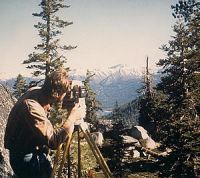
Cadastral Survey
 Cadastral surveys deal with one of the oldest and most
fundamental facets of human society-ownership of land.They are the surveys that create, mark, define, retrace, or reestablish the boundaries and subdivisions of the public lands of the United States.
They are not like scientific surveys of an informative character, which may be amended due to the availability of additional information or because of changes in conditions or standards of accuracy. Although cadastral surveys employ scientific methods and precise measurements, they are based upon law and not upon science.
Cadastral surveys are the foundation upon which rest title to all land that is now, or was once, part of the Public Domain of the United States.
Special Features
 Certified Federal Surveyor Certified Federal Surveyor
"To enhance the level of knowledge and expertise in the professional land surveying community for work performed in Indian Country".
|  CFedS Video CFedS Video
Introducing "Boundary Surveys: Part of Time, History, Land". For years, Indian Trust lands have been plagued with substandard and in many cases conflicting surveys and survey-related services. This issue led the Secretary of the Interior to create and implement a new survey business service, called the Certified Federal Surveyor (CFedS) Program
|
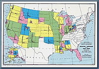 Principal Meridian Map Principal Meridian Map
Map and details of Meridians
of the United States.
|  Manual Next Edition Manual Next Edition
Information regarding the next edition of the Manual of Surveying Instructions.
|
 GLO Records GLO Records
Link to the BLM/GLO Records
automation web site. Includes
patents and plats. |  Tools Tools
Various references, pages, and files,
related to cadastral surveying. |