|
El Malpais National Conservation Area was established in 1987 at the same time as the adjoining El Malpais National Monument. These two areas are managed by different federal agencies. The 263,000-acre El Malpais NCA is managed by the Bureau of Land Management (BLM). The NCA includes two wilderness areas -- West Malpais and Cebolla -- covering almost 100,000 acres. El Malpais translates to "the badlands" in Spanish and is pronounced Mal-(rhymes with wall)-pie-ees. El Malpais NCA was established to protect nationally significant geological, archaeological, ecological, cultural, scenic, scientific, and wilderness resources surrounding the Grants Lava Flows. In addition to the two wilderness areas, the NCA includes dramatic sandstone cliffs, canyons, La Ventana Natural Arch, the Chain of Craters Back Country Byway and the Narrows Picnic Area where primitive camping is possible. There are many opportunities for photography, hiking, camping and wildlife viewing within this unique NCA. For more than 10,000 years people have interacted with the El Malpais landscape. Historic and prehistoric sites provide connections to past times. More than mere artifacts, these cultural resources are kept alive by the spiritual and physical presence of contemporary Indian groups, including the Puebloan peoples of Acoma, Laguna and Zuni, and the Ramah Navajo. These tribes continue their ancestral uses of El Malpais including gathering plant materials, paying respect, and renewing ties. Activities- Guided Programs
El Malpais Summer Hikes 2007: July/August
Ranger guided walks and other activities are offered during the summer season, from Memorial Day through Labor Day. Schedules of activities can be found at the Northwest New Mexico Visitor Center located in Grants, the BLM Ranger Station located on NM 117, or the National Park Service Information Center located off Highway 53.
Also, rangers can provide natural and cultural history talks for organized groups. Please contact BLM in advance to make arrangements. Education groups are welcome and activities can be conducted with school groups if arrangements are made in advance. - Picnicking
The Narrows Picnic Area has five picnic table sites (one of which is accessible via hard pack dirt by wheelchairs) and two vault toilets. At Sandstone Bluffs Overlook, a picnic table and a vault toilet are available. Each visitor center also has one picnic table, water, and restrooms. La Ventana Natural Arch also has a picnic table and two vault toilets. - Camping
El Malpais is in the process of developing an established campground. The National Park Service also allows primitive camping, but a free permit is required. This can be obtained at El Malpais Information Center on NM 53. There are private developed campgrounds in Grants and near El Morro. The US Forest Service, Mt Taylor Ranger District, operates campground in the Grants, NM area. - Bicycles
Mountain bikes are permitted on any of the backcountry roads, however, like motorized vehicles, mechanical bikes or equipment are prohibited from wilderness areas. - Trails
Trails Brochure
Designated trails and routes will help you explore the varied landscapes of El Malpais. Ask at either visitor center for information on these trails: La Ventana Natural Arch Trail, Narrows Rim Trail, Acoma-Zuni Trail, Lava Falls Trail, Cerro Americano Trail, The Continental Divide Trail, Hole-in-the-Wall Trail, Bat Cave Trail, Big Tubes Trail, Braided Cave Trail, or the Ranger Station Nature Trail. Many other opportunities exist to hike to areas or locations that have no trails or along roads that are no longer used ask at El Malpais Ranger Station for suggestions. - Horseback riding
There are numerous places for travel by horse or other stock animal. Contact staff at the visitor center for more information.
Attractions - Sandstone Bluffs Overlook (NPS)
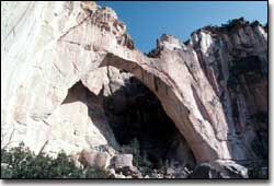
An easy drive on a dirt road leads to a ridge of sandstone above the lava flows. From here you are offered excellent vistas of the El Malpais lava flows and the surrounding countryside. - La Ventana Natural Arch (BLM)
One of the largest of New Mexico’s natural arches, La Ventana was eroded from sandstone deposited during the age of the dinosaurs. - Cebolla Wilderness (BLM)
East of NM 117 lie some 62,000 acres of forested rimrock country. This wilderness is rich in prehistoric archaeological sites, petroglyphs, and historic homesteads. - Narrows Rim Trail (BLM)
Download Brochure
Start from a trailhead located at the southern end of the Narrows Picnic Area, and follow a rock carin trail or the edge of the cliff along the rim of sandstone. The views from the narrows rim are spectacular to say the least. Going to the far end a distance of 4 miles will result in excellent views of La Ventana Natural Arch. - Lava Falls Trail (NPS)
Explore lava features and plant adaptations unique to the McCarty's flow, the youngest lava flow in El Malpais. - West Malpais Wilderness (BLM)
This 40,000 acre wilderness offers hiking on older lava flows and the opportunities for wildlife viewing. Hole-in-the-Wall is one hiking destination. - Hole-in-the-Wall (BLM)
Download Brochure
Younger lava went around this area of older lava flows leaving a ponderosa pine parkland and grassland called a Kipuka (Hawaiian term). - Chain of Craters (BLM)
A line of more than 25 cinder cones that resulted from magma finding a weak spot in the earth’s crust. - Chain of Craters Backcountry Byway (BLM)
A rather rough scenic drive along County Road 42 offers excellent views of the Chain of Craters and access to the Continental Divide Trail and to other attractions. - Continental Divide National Scenic Trail (both NPS & BLM)
A foot path here is part of the national trail stretching from Mexico to Canada along the continental divide. - Big Tubes Area (NPS)
Lava tubes can be huge and this area is home to one of the longest systems in North America. A cairn route leads to Four Windows and Big Skylight Caves, and Caterpillar and Seven Bridges Collapses. - Junction Cave (NPS)
In the El Calderon area this cave offers opportunities for limited cavers to explore a lava tube without lights. Other lava features nearby include double sinks, bat cave, and the El Calderon cinder cone. - Zuni Acoma Trail (NPS)
This ancient puebloan trail follows a trade route between Zuni and Acoma pueblos. This small portion of the trail is a strenuous 7.5 mile one-way hike across four of the major lava flows in this region. - Dittert Site (BLM)
Download Brochure
Sometime between AD 1000 and 1300, the Dittert Site was built and occupied by the Anasazi people. The ruin is a two-story masonry structure that includes 30-35 rooms and a kiva. - Ranger Station Nature Trail (BLM)
Download Brochure
Located on the east end of the ranger station, the nature trail loops approximately 1.25 miles along a mesa rim.
Environment
El Malpais is located at elevations that range from 6,500 to over 8,000 feet above sea level in a semi-desert. Rainfall averages 15 inches annually, and most of that comes during July, August, and September. Thunderstorms are a common occurrence during these summer rains and lightning poses a hazard to hikers. Temperatures range from (daytime 30-50, and nighttime near minus 20 degrees) cold winters to warm summers (daytime 80-100 degrees, nighttime 40-60 degrees). Vegetation varies from low shrubs with a piñon and juniper to ponderosa pine woodlands. Wildflower displays occur mainly in the fall after the summer monsoons, with a modest spring cactus & wildflower display. Wildlife includes a variety of mammals, birds, reptiles, and amphibians. In warmer weather, rattlesnakes are sometimes sighted in the canyons or heard under rocks, so please be alert. Facilities
The ranger station has restrooms, drinking water, and picnic tables. - BLM Ranger Station
Begin your visit at this facility, located off NM 117, nine miles south of Interstate 40. From I-40 take exit 89 and travel south through the northern end of the National Conservation Area. The ranger station is open from 8:30 am to 4:30 pm every day except for Thanksgiving Day, Christmas Day, and New Year’s Day.
The ranger station contains exhibits about the cultural and historical aspects of El Malpais. It also has information on the natural history, birds, plants, geology, and other information about this portion of New Mexico. An eight-minute orientation video is available for viewing upon request. A short hiking trail begins at the visitor center parking area for about a 45-minute hike to great vistas of the nearby area. The visitor center also has a bookstore, picnic table, native plant garden, water, and restrooms. - Parking
Visitor parking is available at all developed sites. The major parking areas are paved, but many other parking areas are on dirt or gravel. Many sites have room for a limited number of RV’s or buses. - Accessibility
El Malpais Ranger Station and restroom facilities throughout the National Conservation Area and National Monument are accessible. The view point trail to La Ventana Natural Arch is accessible and one picnic table at the Narrows Picnic Area will accommodate wheelchairs, but access is on packed dirt. In the monument, a portion of the Sandstone Bluffs Overlook is wheelchair accessible as is a short loop trail at the Zuni-Acoma Trailhead. - Services
Food, lodging, gasoline, and automotive services are available in nearby Grants, NM, or along the I-40 corridor, but not in the National Conservation Area. Water is available at BLM ranger station on State Road 117, the National Park Service visitor center on State Road 53, and the Northwest New Mexico Visitor Center in Grants. There are also numerous places to camp or stay in Grants. Visit the Grants/Cibola County Chamber of Commerce or call 505.287.4802 (9-5, Mon-Sat).
Location / Access
El Malpais is located south of Grants, NM and 80 miles west of Albuquerque. Two state highways provide access to the national conservation area and national monument and both are accessed via Interstate 40. Exit 89, east of Grants, will take you along NM 117 which traverses the east side. Exit 81, west of Grants, will take you along NM 53 which travels down the northwestern edge. The paved roads will accommodate any type of vehicle travel. The condition of backcountry roads recommends high ground clearance, four-wheel drive vehicles, and the condition of some primitive roads requires such vehicles. Mountain bikes, ATVs, dirt bikes and horse travel are also allowed on these roads. Travel with any of the motorized or mechanized equipment must be on designated roads, no cross country travel is allowed except by stock animals or foot. In wilderness areas, access is limited to stock animals and foot traffic. Protections and Precautions
El Malpais National Conservation Area was established by Congress to protect the outstanding archaeological, geological, and wilderness resources surrounding El Malpais lava flows. Help us conserve these resources by staying on designated roads and trails and following posted signs. Leave all artifacts (historic as well as prehistoric) where they are found. We also ask that you practice good land stewardship by following Leave no Trace principles. Any outing in El Malpais should include daypacks with water, snacks, rain gear, first aid kit, and sunscreen. Visitors planning on hiking the lava terrain will need sturdy hiking boots. Exploring the lava tube caves requires being prepared with warm clothing, protective headgear, three sources of light, and leather gloves. Trails can be uneven and steep and even icy in the winter.
 |
| |


Fees
None. Season/Hours
Open year-round. Visitors should be cautious during the monsoon season because unpredictable weather may occur and cause flooding. The national conservation area and monument are always open to visitors except for Sandstone Bluffs Overlook, managed by the National Park Service, which closes at dusk. Other portions of the area may be closed at the request of local tribes for traditional cultural events. Parts of the area and uses may be restricted based on fire dangers or other management needs. Special Rules
See Brochure for El Malpais General Rules and Regulations. Maps Contact Information
Rio Puerco Field Office
435 Montano NE
Albuquerque, NM 87107
505.761.8700 Grants Field Station
P.O. Box 846
Grants, NM 87020
505.287.7911 Additional Information
National Landscape Conservation System
www.publiclands.org
www.recreation.gov Recreation Guidelines
• BLM Recreation Guidelines |
|
|
|