


|
Print Page | ||||||||||||||||||||||||||||||||||||||||||||||||
| Energy | |||||||||||||||||||||||||||||||||||||||||||||||||
|
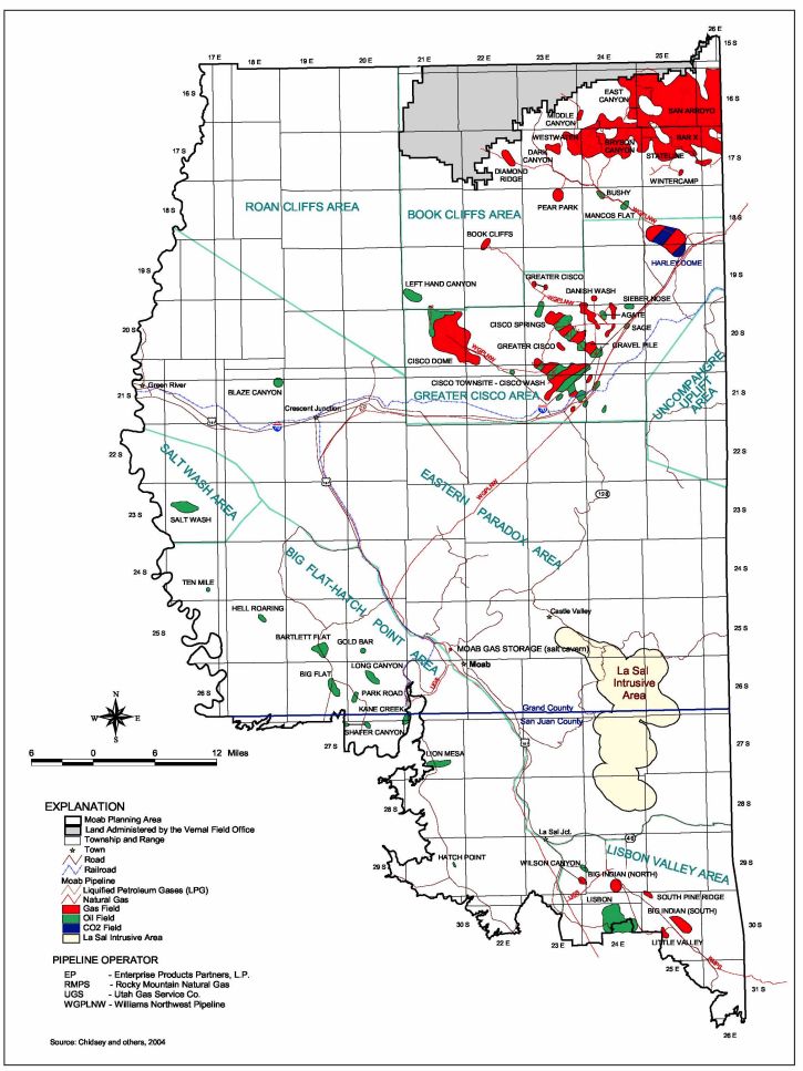
The Moab Field Office has had a long history of oil and gas exploration. Records from the Utah Division of Oil, Gas and Mining (UDOGM, 2004) indicate that approximately 2,027 petroleum wells have been drilled in the Moab Field Office from 1891 through 2004, of which 292 are currently producing, 265 are inactive but capable of producing, 7 are injection wells, and 1,470 are plugged and abandoned (some of which may have been producers at one time). Total cumulative production from fields within the Moab Field Office has been nearly 60 million barrels of oil and 1.2 trillion cubic feet of natural gas, accounting for over 14% of the total gas and over 4% of the total oil produced in Utah. These energy resources are found in 34 oil and gas fields (including 20 active fields, 10 inactive fields, and 4 abandoned fields), that range from relatively small gas fields in the Cisco desert, to the giant Lisbon Valley oil field which has produced over 45 million barrels of oil. Map of Moab Field Office Oil and Gas Fields
The Moab Field Office has been experiencing a significant increase in energy-related work over the past two years.
Table 2 represents production from fields administered by the Moab Field Office since 2000. While production has shown a decline over the past few years, the recent increase in exploration drilling will likely lead to increased production from federal lands in the Field Office. This recent drilling has shown indications of a significant new gas field discovery in an area between Moab and Green River to the northwest. Additional drilling over the next year should provide additional information.
In addition to the drilling activity and oil and gas production from the Moab Field Office, we also routinely work with geophysical companies doing large scale 3-D vibroseis exploration in the area, with two large projects slated for this year. Recent interest and dramatic price increases in uranium are also spurring a resurgence of uranium exploration and drilling in the area. Before Moab was ever known as a recreation mecca, it was “put on the map” by the rich uranium reserves available on the Colorado Plateau. In fact, Moab was once known as the “uranium capital” of the United States in the 1950’s and 60’s. Many of the roads built by the uranium industry now provide the transportation backdrop for increasingly popular mountain bike and motorized recreation use in the area. Exploratory drilling for additional uranium resources is now in full swing, with at least 10 projects over the past two years.
|
|||||||||||||||||||||||||||||||||||||||||||||||||