 |
Investment Opportunities for Managing Transportation Performance through Technology
January 16, 2009
The incoming Obama Administration has laid out several objectives for economic recovery plan investments, such as:
- Ready to go within a few months;
- Yield both short- and long-term benefits; and
- Create and maintain jobs.
In the transportation sector, state and local governments and transit agencies are compiling lists of projects that meet these criteria. AASHTO, APWA and APTA, for example, have identified $64.3 billion, $15.4 billion and $12.2 billion respectively in “shovel-ready” projects that could begin quickly. As transportation is about moving people and goods safely and effectively, it is important to consider the scope and timing of the operational benefits these projects will deliver. Effectively operating the transportation system is a daily process vital to the economy and central to transportation and transit agency missions. Moreover, transportation operations provide continual public and private sector employment opportunities. Intelligent Transportation Systems (ITS) use technology to enable operating agencies and private users to keep transportation systems performing as efficiently and safely as possible.
Investments in ITS and operations are fully consistent with the intent of the economic recovery plan and can be proffered as candidates. For example, ITS investments that support system operations have the following attributes:
Quick to Implement – ITS and operations investments requiring minimal new rights-of-way or construction are subject to a categorical exclusion under NEPA. Examples include traffic signal upgrades and optimization, traffic adaptive signal control, transit signal priority, ramp metering, closed-circuit television, dynamic message signs, open road tolling, weigh-in-motion, transit AVL/CAD, and traffic incident management programs. These projects can get underway fast, turning project dollars into jobs quickly.
Create Jobs – ITS and operations investments create technology sector jobs for engineers, electronics technicians, software developers, and system integrators. On average, about 50 percent of ITS project spending is for direct labor as compared with 20 percent for new highway construction.
Provide Short- and Long-Term Benefits – ITS and operations investments provide long-term operational benefits by reducing congestion and improving transportation safety. ITS technologies employed in work zones provide immediate benefits in congestion management and safety during construction.
Environmental Benefits – ITS and operations investments contribute to reduced emissions and fuel consumption.
When considering ITS and operations investment to support transportation management and operations, keep in mind that they can be:
- Stand-alone deployments;
- Incorporated as elements within new infrastructure-oriented projects; and
- Employed to manage traffic impacts created by other projects, such as work zones.
ITS and operations investments are an important part of a transportation investment portfolio. Summarized below are benefit and cost data for two broad categories of ITS investments: (1) quickly-deployable projects to help maximize the safety, operational capacity, and environmental performance of existing, rehabilitated, or new infrastructure and (2) those that are specifically coupled to road and bridge projects to help mitigate traffic hazards and delays during construction. Project categories identified in this paper could begin within 120 days of funding as either enhancements to existing infrastructure or as elements within broader transportation construction projects.
ITS for Maximizing Infrastructure Benefits
ITS can enhance the quality of life in most communities by improving traffic flow and decreasing delays. Examples of these technologies include traffic signal optimization and retiming, transit signal priority, transit CAD/AVL, safety service patrols, electronic border crossing systems, commercial vehicle credentialing, and surveillance and detection systems. Regarding surveillance and detection, Congress has directed USDOT to establish a real-time traffic and travel condition monitoring system to enable States to use and share that data with other governments and the traveling public. The Department embarked on a regulatory development approach to stimulate and accelerate the expansion of real-time traffic and travel conditions monitoring. A notice of proposed rulemaking (NPRM) was published on January 14, 2009 to engage the transportation community in effective approaches to accomplish this effort. The NPRM does not dictate a specific technology. Examples of technologies used for real-time data collection include roadside, overhead, probe-based, in-pavement sensors, and video detection devices.
Table 1 identifies deployment-ready ITS investments for either stand alone projects or technologies that can be incorporated into new or existing transportation infrastructure projects. The table includes a summary of the key benefits for each type of project, including an assessment of whether the safety, mobility,
Table 1 . ITS Upgrades for New, Rehabilitated or Existing Infrastructure
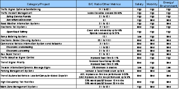
Key: Details on the ITS solutions presented in this table can be found in the supplemental background and appendix sections.
Source: ITS Benefits and Costs databases (http://www.itsbenefits.its.dot.gov/ and http://www.itscosts.its.dot.gov/) and energy and environment impacts are considered to be high, medium, or low. This assessment is based on the information contained in the ITS benefits database.
While these technologies can be deployed independently, there are good engineering, financial and political reasons to include them as elements of other capital projects. Coordinating project installation can leverage resources, minimize total amount of digging and repaving, and reduce the total time for deployment.
ITS for Mitigating Construction Impacts
Construction projects can have traffic impacts that reverberate across a region. As the nation launches numerous construction projects, it will be crucial to move vehicles through the work zones as efficiently as possible and to better manage traffic and inform the traveling public in the surrounding region. Smart work zones, traffic incident management strategies, and enhanced traveler information are among the ITS solutions that can improve safety for workers and the motoring public as well as mitigate traffic delay during road and bridge construction projects. Portable traffic management systems, dynamic message signs, dynamic lane merge systems, and variable speed limit systems are just a few examples of smart work zone technologies that can be deployed during major construction projects. Table 2 follows the same format at table 1 and lists the significant benefits associated with integrating work zone management components with roadway and bridge construction projects. On average, the cost to deploy and operate smart work zone systems is 4.5 percent of total construction costs.
Table 2 . ITS for Minimizing Road Construction Hazards and Delays
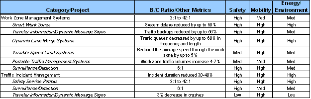
Key: Details on the ITS solutions presented in this table can be found in the supplemental background and appendix sections.
Source: ITS Benefits and Costs databases (http://www.itsbenefits.its.dot.gov/ and http://www.itscosts.its.dot.gov/)
Investment Opportunities for Managing Transportation Performance: Background Information on Candidate ITS Technologies
Background Information on Candidate ITS Technologies
This section provides more information on the benefits and costs of the technologies listed in the tables 1 and 2 of the summary paper.
Traffic Signal Optimization/Retiming
Traffic signal system retiming and optimization ranks as one of the most cost-effective urban transportation improvement actions, increasing mobility, reducing fuel consumption, and improving environmental quality. The extent of benefits realized from traffic signal retiming depends on various factors including the quality of existing timing plans, street network configuration, and traffic patterns. For example, the Traffic Light Synchronization Program in Texas reduced delay by 24.6 percent, lowered travel time by 14 percent, and demonstrated a benefit-to-cost ration of 62:1. Signal retiming projects in several U.S. and Canadian cities have been shown to reduce fuel consumption by 2 to 9 percent and emissions by 1 to 6 percent. For optimal performance, traffic signal timing plans need to be updated at least every three to five years, and possibly more frequently depending on growth and changes in traffic patterns. The cost of retiming a signal is approximately $3,000. Based on the estimated 272,000 traffic signals in the United States and assuming that a fourth of these signals are retimed every year, the annual costs of signal retiming is roughly $200 million.
Depending on the condition of existing hardware and need for replacement, traffic signal timing projects provide a good opportunity for skilled technology jobs. These projects can be started and implemented immediately and deliver mobility and environmental benefits quickly.
Traffic Incident Management
Traffic incident management programs have demonstrated success in improving mobility, safety, efficiency, productivity, energy and environment, and customer satisfaction. Managing traffic incidents is a proven strategy for addressing significant portions of the Nation’s traffic congestion problems. Traffic crashes are the most time-consuming of these incidents, but the more numerous cases of stalled vehicles, roadway debris, and other incidents also contribute significantly to the problem. Traffic incident management programs make use of a variety of ITS technologies to successfully detect, manage, and clear traffic incidents; improving safety for travelers by reducing the risk of secondary crashes; and reducing time lost and fuel wasted in traffic backups. The most significant findings of traffic incident management programs are the ability to dramatically reduce the duration of traffic incidents, from 15 to 65 percent, with the bulk of studies finding savings of 30 to 40 percent. Studies have also shown that integrating traveler information with traffic and incident management systems could reduce emissions by up to 3 percent and could improve fuel economy by about 1.5 percent. Traffic incident management programs can have a short start up depending on the resources a region has available and if a current system is being enhanced or expanded.
Safety Service Patrols
Safety Service patrols, which preceded the emergence of ITS technologies, are now frequently incorporated into traffic incident management programs. The patrol vehicles and staff, supported by an array of other ITS components, enable significant reductions in the time to respond to and clear incidents. Service patrols are considered one of the most essential components of a successful traffic incident management program. In Florida, the Road Ranger Service Patrol program saved over 1.7 million gallons of fuel by eliminating over one million vehicle-hours of delay in 2004.
More recently, safety service patrols have become an effective component of work zone management systems, especially for long-duration work zones. State DOTs typically spend from $5.6 million to $13.6 million per year on these programs. Proactive incident management via service patrols represents a benefit heartily welcomed by travelers. Service patrols are perhaps the most prominent and widely evaluated component of traffic incident management programs. Safety service patrol services can be implemented quickly as they can be successful with minimal infrastructure support.
"I truly felt my life was in danger as cars and trucks whizzed by…I felt my life was saved today due to this service…"
Surveillance and Detection
Many strategies for arterial, freeway, and incident management systems are enabled by traffic surveillance and detection technologies, such as sensors or cameras monitoring traffic flow. A variety of surveillance and detection technologies can help spot incidents quickly. These include inductive loop, acoustic, and microwave vehicle detectors, and camera systems providing frequent still images or full-motion video. These types of ITS technologies help incident management staff identify incidents quickly. Surveillance and detection solutions along a corridor or within a region can provide considerable long-term benefits and are critical elements for establishing nationally available, real-time traffic and travel condition monitoring system.
A variety of technologies are used to detect incidents. Traffic surveillance cameras monitor 34 percent of freeway miles in the country’s 108 largest metropolitan areas. Free cellular telephone calls to a dedicated number are available for 24 percent of the freeway miles, automatic incident detection systems monitor 17 percent, and call boxes monitor 12 percent.
Road Weather Information Systems
Road weather management systems mitigate weather impacts by using technology to promote safety, increase mobility, improve productivity, and protect the environment. Adverse weather conditions pose a significant threat to the operation of the Nation’s roads. According to the National Research Council, motorists endure more than 500 million hours of delay each year as a result of fog, snow, and ice. Rain, which occurs more frequently than snow, ice, and fog, leads to even greater delay. Adverse weather not only affects safety but also degrades traffic flow and increases travel times. Under extreme conditions (such as snowstorms), travel times can increase by as much as 50 percent.
Road Weather Information Systems (RWIS) are now critical components of many agencies’ winter maintenance programs. Accurate and timely road weather information helps maintenance managers react proactively before problems arise, improving safety while reducing costs. RWIS systems are designed to help winter maintenance operations decisions by facilitating the sharing of information about hazardous road conditions. In addition, the implementation of these systems improves the overall transportation infrastructure by reducing operations and maintenance costs, increasing safety of drivers, and decreasing damage to the environment from salt and other de-icing agents.
Ninety-four percent of surveyed users of a road weather information Web site covering roadways in Washington agree that the weather information made travelers better prepared for their trips. Over half of the respondents (56 percent) agreed the information helped them avoid travel delays.
Electronic Toll Systems/Open Road Tolling
Electronic Toll Collection (ETC) is one of the most successful ITS applications with numerous benefits related to delay reductions, improved throughput, and fuel economy. For example, New Jersey Turnpike’s EZ-Pass system provided annual fuels savings of 1.2 million gallons across 27 tolling locations; Baltimore cut environmentally harmful emissions by 16 to 63 percent at toll plazas that were upgraded to ETC. With advanced technologies such as open road tolling (ORT), toll transactions can be processed automatically at freeway speeds reducing the need for tollbooth barriers and improving performance. ORT concepts can be incorporated into new toll plaza designs or constructed at existing plazas that currently have speed-controlled, dedicated ETC lanes. For example, in Florida, the addition of ORT to an existing ETC mainline toll plaza decreased delay by 50 percent for manual cash customers and by 55 percent for automatic coin machine customers, and increased speed by 57 percent in the express lanes. A feasibility study for electronic toll collection on the Florida Turnpike indicated that a 10 to 30 percent participation rate would yield benefit-to-cost ratios of 2:1 to 3:1, respectively.
ORT is being implemented to replace existing toll booth facilities that impede traffic flow and create congestion. Many ORT projects can be implemented near-term as enhancements to existing toll facilities, creating an immediate economic benefit that will improve long-term safety, mobility and environmental impacts.
Ramp Metering Systems
Ramp metering systems use traffic signals at on-ramps to control the rate of vehicles entering the freeway. The signals can be set for different metering rates to optimize freeway flow and minimize congestion. Signal timing algorithms and real-time data from mainline loop detectors are often used for more effective results.
Ramp metering systems provide a high rate of return on investment offering considerable safety, mobility and environmental benefits in congested urban areas. For example, in the St. Paul, MN region, ramp metering has increased throughput by 30 percent and increased peak period speeds by 60 percent. Simulation studies estimate that ramp metering can save 2 to 55 percent of the fuel expended at each ramp Ramp metering systems can be a low cost solution for maximizing existing capacity, either as a stand-alone project or as one component of a larger transportation management system.
Electronic Border Crossing Systems
ITS applications for commercial vehicle operations (CVO) are designed to enhance communication between motor carriers and regulatory agencies, particularly during interstate freight movement. ITS applications can assist carriers and agencies in reducing operating expenses through increased efficiency and aid in ensuring the safety of motor carriers operating on the Nation’s roadways. ITS/CVO is the term used for the ITS elements that support commercial vehicle operations. These include information systems, networks, sensor systems such as weigh-in-motion (WIM), technologies such as electronic border crossing systems, brake testing equipment, and the components of intelligent commercial vehicles.
- Electronic border crossing components are implemented to improve the safety, security and efficiency of legal crossings between the United States and Canada or Mexico. Border crossing deployments could realize a return on investment the first year of deployment because of the high volume of transponder-equipped trucks. While an integrated system may not be feasible in the short-term, the deployment of electronic border crossing components to enhance existing facilities can have near-term economic benefits while providing positive long-term transportation investments. The implementation of electronic border crossing components are relatively low cost solutions with high benefits to the overall system infrastructure, including reduced operational costs, improved mobility through travel time savings at the border, and reduced energy and environmental impacts.
CVISN/Electronic Credentialing and Electronic Screening
The Commercial Vehicle Information System and Networks (CVISN) program has created a nationwide framework of communication links that State agencies, motor carriers, and stakeholders can use to conduct business transactions electronically. Electronic registration and permitting at State agencies allows carriers to register online, decreasing the turn-around time associated with permit approval. In addition, safety information exchange (SIE) programs have been implemented as part of CVISN to standardize the exchange of vehicle and driver safety information among states and jurisdictions. Enforcement personnel at check stations can use national database clearinghouses to confirm carrier regulatory compliance data and crosscheck safety assurance information. CVISN includes information systems owned and operated by governments, carriers, and other stakeholders, but excludes the sensor and control elements of ITS/CVO.
Implementing electronic screening and electronic credentialing can provide low cost solutions that result in high benefits to the overall system infrastructure. For example, electronic credentialing reduced paperwork and saved carriers participating in the CVISN Model Deployment 60 to 75 percent on credentialing costs. Significant benefits to commercial vehicles include reduced operational costs, improved mobility through travel time savings, and reduced energy and environmental impacts.
Bus Rapid Transit
Bus Rapid Transit (BRT) systems can significantly benefit from numerous ITS technologies such as TSP, fare payment systems, and CAD/AVL. Vehicle Assist and Automation Systems (VAA) are unique to BRT and consist of four applications that provide driver assistance and automation capabilities to a transit vehicle including precision docking, vehicle guidance, platooning, and automated vehicle operations. These applications become an integral component of bus rapid transit (BRT) systems that have gained prominence in the United States. The development and deployment of VAA technologies requires skilled labor capable of integrating technology and software with transit vehicles. An analysis conducted in 2005 demonstrated a significant benefit/cost ratio for several different case study applications ranging from 1.9 to 9.5. The overall benefits were often seen within the first year of operation and were valued, over the life of the technology, upwards of $7 million. There are several planned and designed systems in the United States that "shovel-ready."
Traffic Adaptive Signal Control
Traffic signal optimization provides coordination along arterials to improve traffic flow, reduce delays and stops at traffic signals, and cut harmful emissions. These projects are among the most cost effective projects a traffic engineering agency can undertake. Some agencies have chosen to take optimization one step further by implementing Traffic Adaptive Signal Control. Traffic adaptive signal control systems coordinate the control of traffic signals along arterial corridors, adjusting the lengths of signal phases based on prevailing traffic conditions. Adaptive signal control systems use algorithms that perform real-time optimization of traffic signals based on current traffic conditions, demand, and system capacity. Detection systems in the roadway or overhead inform the controllers of actual traffic and the signals adapt to prevailing conditions. Traffic adaptive signal control can improve traffic flow under recurring congestion as well as traffic conditions caused by incidents and special events and deliver environmental benefits. For example, adaptive signal control in Toronto, Canada has yielded emission reductions of three to six percent and fuel savings of four to seven percent.
- Traffic adaptive signal control can be used to either enhance or expand an existing traffic signal system. Traffic adaptive projects can be started and implemented quickly in an existing system, providing a good opportunity for immediate skilled technology jobs.
Transit Signal Priority
Transit Signal Priority (TSP) is a cost-effective method to make bus-based transit service more reliable. TSP is often implemented on a conditional basis intended to help transit vehicles improve schedule performance by granting priority to transit vehicles at signalized intersections when they are behind schedule. TSP systems use sensors or transponders to detect approaching transit vehicles and alter the traffic signal timing to improve transit performance. For example, some TSP systems extend the duration of green signals for transit vehicles when necessary. TSP systems, through coordination with arterial management systems, can improve service quality and transit agency productivity resulting in additional ridership. Environmental benefits to the system include fuel consumption reductions for buses up to 19 percent and a reduction in bus emissions up to 30 percent.
Surveys found that riders on Vancouver’s 98 B-line BRT service, which implemented transit signal priority to improve schedule reliability, rated the service highly with regard to on-time performance and service reliability (an average of 8 points on a 10-point scale).
- Transit priority systems can be implemented to improve the mobility of the bus system making it more reliable. These projects can be started and implemented quickly should an agency desire.
Traveler Information/Dynamic Message Signs
State, regional, and local transportation agencies have responsibility for the operation of large permanent dynamic message signs (DMSs) or portable DMSs. DMSs are traffic control devices used for traffic warning, regulation, routing and management, and are intended to affect the behavior of drivers by providing real-time, traffic-related information such as traffic conditions, incidents, weather, construction, safety, and special events. DMSs are ITS solutions that provide safety and mobility benefits in many settings including urban, suburban, rural, and work zones. For example, in Houston, real-time travel time information posted on DMS influenced drivers’ route choice. Eighty-five percent of respondents indicated that they changed their route based on the information provided. Of these respondents, 66 percent said that they saved travel time as a result of the route change. Overall, drivers were primarily interested in seeing incident and travel time information. DMSs can have environmental benefits as well. In San Antonio, Texas, an evaluation study found that using roadside dynamic message signs for incident management could reduce fuel consumption by 1.2 percent.
DMSs can be deployed quickly one at a time, in multiples as a DMS system, or as part of an advanced traveler information system.
Parking Management Systems
Parking management systems are most commonly deployed in urban centers or at modal transfer points such as airports and outlying transit stations. They monitor the availability of parking and disseminate the information to drivers, reducing traveler frustration and traffic congestion associated with searching for parking spaces. Studies of parking management systems demonstrate the potential of these systems to improve traffic flow in congested urban areas and improve travelers’ experiences at major transportation facilities such as airports and suburban transit and commuter rail stations.
In Baltimore Maryland at the Baltimore/Washington International Thurgood Marshall (BWI) airport a parking guidance system was implemented which directs travelers to individual available parking spaces. An October 2003 survey of BWI travelers found that 81 percent of surveyed travelers indicated that parking was easier at BWI than at the other airports they frequented and 68 percent agreed that parking was faster.
Transit Automated Vehicle Location/Computer-Aided Dispatch
Transit operations and fleet management ITS applications improve transit reliability through the implementation of automated vehicle location (AVL) and computer-aided dispatch (CAD) systems. These systems can improve both the experience for transit riders by reducing passenger wait times and the efficiency of transit operations by enabling more efficient planning, scheduling, and management of transit assets and resources. Information on current vehicle location and schedule status can also support transit signal priority, which improves transit trip times and schedule adherence. Data records from AVL/CAD systems, along with automated passenger counters, are enabling a transition to improved transit planning and management strategies which rely on large quantities of system operations data.
Transit agencies have reported reductions in fleet requirements ranging from two to five percent as a result of improved fleet utilization. Data from transit systems in Portland, OR; Milwaukee, WI; and Baltimore, MD show that AVL/CAD systems have improved schedule adherence by 9 to 23 percent.
High Occupancy Toll Facilities
High-occupancy toll (HOT) lane facilities charge single-occupancy vehicles (SOV) for the use of a high-occupancy vehicle (HOV) lane. Accessing HOT lanes remains free for transit vehicles, vanpools, and carpools. The toll charged for SOVs can be dynamically adjusted to ensure traffic volume does not exceed an established threshold for all vehicles in the HOV lanes such that free-flow travel conditions are maintained. Toll collection is performed electronically using open road tolling to allow high speed toll collection. Tolls are charged at fixed points along the facility.
In Minneapolis, MN, survey data collected prior to the deployment of MnPASS Express Lanes (HOT lanes) on I-394 were examined to determine travelers’ willingness-to-pay to avoid congestion. The results indicated that 59 percent of travelers would pay $2 to save 20 minutes; 40 percent would pay $2 to save 15 minutes; 23 percent would pay $2 to save 10 minutes; and less than 10 percent would pay $2 to save 5 minutes. Willingness-to-pay also decreased as toll rates increased. Virtually no one was willing to pay more than $6 for any amount of time savings.
HOT facilities are being built into new HOV construction projects, as well as being implemented on existing HOV facilities to provide system enhancements with minimal construction. Many HOT projects can be implemented near-term, creating an immediate economic benefit that will produce both skilled and unskilled job opportunities.
Work Zone Management Systems
ITS applications in work zones include the temporary implementation of traffic management or incident management capabilities. These temporary systems can be stand-alone or they may supplement existing systems during construction. Other applications control speed limit displays or notify travelers of changes in lane configurations, travel times, and delays through the work zones. Systems for work zone incident management can also be used to more quickly detect incidents and better determine the appropriate degree of response needed, thereby limiting the amount and duration of additional capacity restrictions.
ITS solutions for work zone management include components such as smart work zones, traveler information/portable DMS, dynamic lane merge systems, variable speed limit systems, and portable traffic management systems including surveillance and detection, and safety service patrols. ITS may also be used to manage traffic along detour routes during full road closures. Network simulation models estimate that smart work zones can reduce total delay by 41 to 75 percent.
As "shovel ready" highway projects begin during the next few months, this tremendous construction program may, in the short run, reduce traffic safety and mobility across the country. Work zone management programs in the form of smart work zones coordinated with traffic incident management programs will be essential in mitigating these impacts and keeping the public moving safely and efficiently through these construction zones. A properly designed smart work zone will keep motorists informed, encourage motorists to take alternate routes, reduce congestion through the work zone, improve clearance of incidents, and make work zones safer for workers and the traveling public. Implementing smart work zones will help mitigate traffic congestion and traveler delay associated with these construction projects.
Investment Opportunities for Managing Transportation Performance: Candidate ITS Technology Appendices
Fact Sheets on ITS Categories
Traffic Signal Optimization/Retiming
Traffic Incident Management
Safety Service Patrols
Surveillance and Detection
Road Weather Information Systems
Electronic Toll Systems/Open Road Tolling
Ramp Metering Systems
Electronic Border Crossing Systems
Commercial Vehicle Information Systems and Networks
Bus Rapid Transit
Traffic Adaptive Signal Control
Transit Signal Priority
Traveler Information/Dynamic Message Signs
Parking Management Systems
Transit Automated Vehicle Location/Computer-Aided Dispatch
High Occupancy Toll Facilities
Work Zone Management Systems
Traffic signal system retiming and optimization ranks as one of the most cost-effective urban transportation improvement actions, increasing mobility, reducing fuel consumption, and improving environmental quality. The extent of benefits realized from traffic signal retiming depends on various factors including the quality of existing timing plans, street network configuration, and traffic patterns. For optimal performance, traffic signal timing plans need to be updated at least every three to five years, and possibly more frequently depending on growth and changes in traffic patterns. The cost of retiming a signal is approximately $3,000. Assuming that there are 265,000 traffic signals in the United States and if a fourth of these signals are retimed every year, the annual costs of signal retiming is roughly $200 million.
Benefits
- Delays can decrease by 13 to 94 percent.
- Travel time can fall by 7 to 25 percent.
- The Traffic Light Synchronization Program in Texas reduced delay by 24.6 percent and lowered travel time by 14 percent.
- Traffic signal retiming at 11 intersections on U.S. Route 1 in St. Augustine, Florida reduced delay by 36 percent, and lowered travel time by 10 percent.
- A retiming project for eight intersections on State Route 26 in Gainesville, Florida decreased average delay by 94 percent.
- In Burlington, Canada, signal retiming at 62 intersections lowered travel time by 7 percent.
- In Montgomery County, MD traffic signal retiming reduced delay by 13 percent.
- In Oakland County, Michigan retiming 640 traffic signals during a two-phase project resulted in Carbon monoxide reductions of 1.7 and 2.5 percent, Nitrogen oxide reductions of 1.9 and 3.5 percent, and hydrocarbon reductions of 2.7 and 4.2 percent.
- Signal retiming projects in several U.S. and Canadian cities reduced fuel consumption by 2 to 9 percent.
Costs
- The National Traffic Signal Report Card: Technical Report (2007) prepared by the National Transportation Operations Coalition (NTOC) estimates that routine traffic signal timing updates cost $3,000 or less per intersection. The NTOC study recommends updating signal timing plans every three to five years, or more frequently depending on growth and changes in traffic patterns. The United States has approximately 272,000 traffic signals.
B/C Ratios
- The estimated benefit-to-cost ratio for optimizing signal timing plans, coordinating traffic signal control, and implementing adaptive signal control in California was 17:1.
- The Traffic Light Synchronization program in Texas demonstrated a benefit-to-cost ratio of 62:1
Traffic incident management programs have demonstrated success in improving mobility, safety, efficiency, productivity, energy and environment, and customer satisfaction. Managing traffic incidents is a proven strategy for addressing significant portions of the Nation’s traffic congestion problems. Traffic crashes are the most time-consuming of these incidents, but the more numerous cases of stalled vehicles, roadway debris, and other incidents also contribute significantly to the problem. Traffic incident management programs make use of a variety of ITS technologies to successfully detect, manage, and clear traffic incidents; improving safety for travelers by reducing the risk of secondary crashes; and reducing time lost and fuel wasted in traffic backups.
Traffic incident management programs make use of a variety of ITS technologies to successfully detect, manage, and clear traffic incidents; improving safety for travelers by reducing the risk of secondary crashes; and reducing time lost and fuel wasted in traffic backups. Other ITS components are deployed to provide traveler information and to improve overall freeway and arterial operations and management. Traffic incident management programs are typically implemented concurrently with freeway management systems, but it is important to keep in mind that arterials can be included in incident management programs as well.
Benefits
- Success builds from the ability of the programs to significantly reduce the duration of traffic incidents, from 15 to 65 percent, with the bulk of studies finding savings of 30 to 40 percent.
- Integrating traveler information with incident management systems can increase peak period freeway speeds by 8 to 13 percent, 2 improve travel time, and according to simulation studies, reduce crash rates and improve trip time reliability with delay reductions ranging from 1 to 22 percent.
- A San Antonio, Texas deployment of DMS, combined with an incident management program, resulted in a 2.8 percent decrease in crashes.
- The Coordinated Highway Action Response Team in Maryland reduced incident duration and related secondary incidents by 29 percent in 2002, eliminating 377 crashes within its coverage area.
- A simulation study indicated that integrating traveler information with traffic and incident management systems in Seattle, Washington could reduce emissions by 1 to 3 percent, lower fuel consumption by 0.8 percent, and improve fuel economy by 1.3 percent.
- In Georgia, the NaviGAtor incident management program reduced annual fuel consumption by 6.83 million gallons, and contributed to decreased emissions: 2,457 tons less Carbon monoxide, 186 tons less hydrocarbons, and 262 tons less Nitrous oxides.
Costs
- Florida : The Severe Incident Response Vehicle (SIRV) program provides a 24-hour incident command station and support to Florida DOT and Road Rangers during major incidents such a tractor-trailer rollovers, hazardous material incidents, and fatalities. The SIRV services are contracted out. Originally launched as a pilot program, the SIRV program was awarded in October 2006 with funding through 2012. The 2006 annual operating cost for the SIRV program was $500,000.
Safety Service patrols, which preceded the emergence of ITS technologies, are now frequently incorporated into traffic incident management programs. The patrol vehicles and staff, supported by an array of other ITS components, enable significant reductions in the time to respond to and clear incidents. Service patrols are considered one of the most essential components of a successful traffic incident management program. More recently, safety service patrols have become an effective component of work zone management systems especially for long-duration work zones. State DOTs typically spend from $5.6 million to $13.6 million per year on these programs. Proactive incident management via service patrols represents a benefit heartily welcomed by travelers. Service patrols are perhaps the most prominent and widely evaluated component of traffic incident management programs. Safety service patrol services can be short start-up programs since they can be successful with minimal infrastructure support.
Service patrols are perhaps the most prominent and widely evaluated component of traffic incident management programs. They have been the subject of numerous benefit-to-cost analyses over the course of their deployment, with 26 studies of the programs completed in 23 U.S. cities between 1994 and 2005. These studies document benefit-to-cost ratios ranging from 2:1 to 36:1.
Benefits
- Service patrols are well-received by the public. Operating agencies often receive thank you letters from grateful motorists assisted by service patrols.
- Reductions in incident-related delay also lead to fuel savings and related emissions reductions. A benefit-to-cost analysis of Florida’s Road Ranger service patrol documented a savings of 1.7 million gallons of fuel across the state in 2004.
Costs
- Regional service patrols are often in the range from $1.5 million to $2.5 million per year. However, for large, densely populated areas such as Los Angeles, California, the cost can be upwards of $20.5 million per year, or as low as $0.4 million in the Salt Lake City, Utah area. The cost of service patrols vary considerably depending on population, number of freeway miles covered, and the types and hours of services provided.
- Labor for Incident Response: $107K-$131K (annually)
- Tennessee : The Tennessee DOT HELP program began in July 1999 for the purposes of reducing traffic congestion, improving safety, and assisting motorists in distress. Annual operating costs include salaries, vehicle operation and maintenance, fuel, supplies, and other related operating costs. The total annual operating cost for FY 2006 was $6.5 million. Total annual operating cost for FY 2005 was $5.6 million.
- Road Ranger is the name of the highway service patrol program in Broward County, Florida. The Road Ranger program includes contracted services and leased vehicles. The program utilizes 11 vehicles covering approximately 58 centerline miles on portions of I-95 and I-75, and all of I-595. Road Rangers provide 24-hour service. The 2006 annual operating cost for Florida DOT District IV Road Ranger Program was $2.5 million.
B/C Ratio
- Georgia: The Highway Emergency Response Operators motorist assistance patrol program and NaviGAtor incident management activities in the Atlanta area saved more than 187 million dollars yielding a benefit-to-cost ratio over 4:1.
- Indiana : The Hoosier Helper freeway service patrol program in Northwest Indiana had a projected benefit-to-cost ratio of nearly 5:1 for daytime operations, and over 13:1 for 24-hour operations.
Many strategies for arterial, freeway, and incident management systems are enabled by traffic surveillance and detection technologies, such as sensors or cameras monitoring traffic flow. A variety of surveillance and detection technologies can help detect incidents quickly. These include inductive loop, acoustic, and microwave vehicle detectors, and camera systems providing frequent still images or full-motion video. These types of ITS technologies help incident management system personnel identify incidents quickly. Surveillance and detection solutions along a corridor or within a region can provide considerable long-term benefits and are critical elements for establishing nationally available, real-time traffic and travel condition monitoring system.
Benefits
- The Maryland Coordinated Highways Action Response Team (CHART) program is in the process of expanding to more automated surveillance with lane sensors and video cameras. Lane sensors and freeway video cameras in the coverage area supported incident management and contributed to a 5 percent reduction in non-recurrent congestion.
Costs
- Utah : The Utah CommuterLink advanced transportation management system includes over 230 cameras to observe incidents and congested areas. Camera coverage is primarily on freeways and grade-separated facilities; however, there are some deployments at key intersections on surface streets. The capital cost of the cameras, $8.4 million, includes the cameras and installation. Operational cost of the cameras is $75,600 per year.
- California : The Cities of Concord and Walnut Creek investigated alternatives for transmitting real-time traffic video from field devices to each city’s respective traffic operations center (TOC). The capital cost for video over existing copper interconnect was $95,910 for a five mile corridor. The capital cost for video over new fiber optic cable was $160,700 for a five-mile corridor.
- Unit Costs associated with Surveillance and Detection
- Inductive Loops on Corridor: $3K-$8K
- Remote Traffic Microwave Sensor on Corridor: $9K-$13K per sensor
- Closed Circuit Television (CCTV) Video Camera: $9K-$19K
- Software for Incident Detection: $83K-$101K
- Labor for Incident Detection: $751K-$917K for multiple staff (annually)
- Conduit Design and Installation — Corridor: $50K-$75K (per mile)
- Fiber Optic Cable Installation: $20K-$52K (per mile)
B/C Ratio
The evaluation of the initial operation of the program shows a benefit-to-cost ratio of 5.6:1.
Road weather management systems mitigate weather impacts by using technology to promote safety, increase mobility, improve productivity, and protect the environment. Adverse weather conditions pose a significant threat to the operation of the Nation’s roads. According to the National Research Council, motorists endure more than 500 million hours of delay each year as a result of fog, snow, and ice. Rain, which occurs more frequently than snow, ice, and fog, leads to greater delay. Adverse weather not only affects safety but can also degrade traffic flow and increase travel times. Under extreme conditions (such as snowstorms), travel times can increase by as much as 50 percent.
Road Weather Information Systems (RWIS) are now critical components of many agencies’ winter maintenance programs. Accurate and timely road weather information helps maintenance managers react proactively before problems arise, improving safety while reducing costs. RWIS systems are designed to help winter maintenance operations decisions by facilitating the sharing of information about hazardous road conditions. In addition, the implementation of these systems improve the overall transportation infrastructure by reducing operations and maintenance costs, increasing safety of drivers, and decreasing damage to the environment from salt and other de-icing agents. Enhancing and expanding components of existing RWIS systems are low cost solutions that can lead to near-term economic gain though new skilled and unskilled job opportunities.
Benefits
- Evaluation data show that anti-icing programs can lower snow and ice control costs by 10 to 50 percent and reduce crash rates by 7 to 83 percent.
- Maintenance managers indicate that effective anti-icing and pre-wetting strategies reduce sanding applications by 20 to 30 percent, decrease chemical applications by 10 percent, and reduce chloride and sediment runoff in local waterways.
- Winter maintenance personnel from several agencies indicated that use of RWIS decreases salt usage and anti-icing techniques limit damage to roadside vegetation, groundwater, and air quality (in areas where abrasives are applied).
- Analysis of fixed anti-icing systems deployed on bridges in Utah, Minnesota, and Kentucky found crash reductions from 25 to 100 percent.
Costs
- As with most ITS deployments, costs of road weather management systems vary based on several factors, including their scope, complexity and particular technology or technologies under consideration.
- Roadside Detection subsystem
- Transportation Management Center subsystem
- Roadside Telecommunications subsystem
- Roadside Detection:
- Environmental Sensor Station (Weather Station): $30K-$49K each
- Closed Circuit Television (CCTV) Video Camera: $9K-$19K each
- Transportation Management Center :
- Road Weather Information System (RWIS): $11K
- Roadside Telecommunications:
- Conduit Design and Installation — Corridor: $50K-$75K per mile
- Fiber Optic Cable Installation: $20K-$52K per mile
B/C Ratios
- Staff meteorologists, stationed at the transportation management center in Salt Lake City, Utah, provided detailed weather forecast information to winter maintenance personnel, reducing labor and materials costs for snow and ice control activities and yielding a benefit-to-cost ratio of 10:1.
- A study of a weather and road condition controlled system of VSL signs in Finland showed favorable results for deployment along highly trafficked road segments. Starting benefit-to-cost ratios ranged from 1.1:1 to 1.9:1. The ratio was higher if safety assumptions were higher and there was greater use of higher speed limits.
- With more efficient application of anti-icing chemicals and abrasives, reduced maintenance costs, reduced delay, and increased safety; benefit-to-cost ratios for RWIS and anti-icing strategies range from 2:1 to 5:1.
Electronic Toll Systems/Open Road Tolling Fact Sheet
Electronic Toll Collection (ETC) is one of the most successful ITS applications with numerous benefits related to delay reductions, improved throughput, and fuel economy. With advanced technologies such as open road tolling (ORT), toll transactions can be processed automatically at freeway speeds reducing the need for tollbooth barriers and improving performance. ORT concepts can be incorporated into new toll plaza designs or constructed at existing plazas that currently have speed-controlled, dedicated ETC lanes.
ORT is being implemented to replace existing toll booth facilities that impede traffic flow and create congestion. Many ORT projects can be implemented near-term as enhancements to existing toll facilities, creating an immediate economic benefit that will improve long-term safety, mobility and environmental impacts.
Benefits
- In Florida, the addition of Open Road Tolling (ORT) to an existing Electronic Toll Collection (ETC) mainline toll plaza decreased crashes by an estimated 22 to 26 percent.
- In Florida, the addition of Open Road Tolling (ORT) to an existing Electronic Toll Collection (ETC) mainline toll plaza decreased delay by 50 percent for manual cash customers and by 55 percent for automatic coin machine customers, and increased speed by 57 percent in the express lanes.
- New Jersey Turnpike’s EZ-Pass system provided 1.2 million gallons annual fuels savings across 27 tolling locations.
- Environmentally harmful emissions were reduced by 16 to 63 percent at Baltimore, MD toll plazas upgraded to ETC.
Costs
Florida : To provide expanded mobility, the Miami-Dade Expressway Authority will convert toll operations to ORT during 2007 through 2011. The authority owns and operates a network of five expressway segments, which cover 31 centerline miles, in metropolitan Miami. The ORT program capital cost is estimated at $56.5 million: $20.8 million for project development, public outreach, and system-wide technology development (e.g., back office processing), and $35.7 million for infrastructure and roadside technology along the five expressway segments. The fiber optic backbone needed to connect the roadside equipment to the host location will be provided by others; hence, the associated cost is not included in the above estimate. Costs ID: 2008-00169
Ramp metering systems use traffic signals at on-ramps to control the rate of vehicles entering the freeway. The signals can be set for different metering rates to optimize freeway flow and minimize congestion. Signal timing algorithms and real-time data from mainline loop detectors are often used for more effective results.
Ramp metering systems provide a high rate of return on investment offering considerable safety, mobility and environmental benefits in congested urban areas. For example, In the St. Paul, Minnesota region, ramp metering has increased throughput by 30 percent and increased peak period speeds by 60 percent. Ramp metering systems can be a low cost solution for maximizing existing capacity, either as a stand-alone project or as one component of a larger transportation management system.
Benefit
- Available data shows that ramp metering can improve mainline traffic speeds by 13 to 26 percent, increase throughput by 5 to 30 percent, limit ramp meter delay, and reduce crashes by 15 to 50 percent.
- A study of the integrated deployment of freeway ramp metering and adaptive signal control on adjacent arterial routes in Glasgow, Scotland found a 20 percent increase in vehicle throughput on the arterials and a 6 percent increase on freeways. Arterial traffic increased 13 percent after implementation of ramp metering and an additional 7 percent with the initiation of adaptive signal control.
- In Salt Lake Valley, Utah, a ramp metering study showed that with a metering cycle 8 seconds long, mainline peak period delay decreased by 36 percent or 54 seconds per vehicle.
- A simulation study of the Minneapolis-St. Paul, Minnesota system found 2 to 55 percent fuel savings at individual ramp metering locations along 2 modeled corridors under varying levels of travel demand.
Cost
- The cost of Minnesota DOT (Mn/DOT) ramp metering operations in the Twin Cities metropolitan area in fiscal year 2000 was $210,000 and included staff to monitor and adjust meter settings, conduct field reviews, and respond to inquiries from the public and media.
- Colorado : The Colorado DOT implemented ramp metering to regulate the flow of traffic onto freeways as part of the Transportation Expansion (T-REX) project. Each ramp meter site costs approximately $50,000, which includes the cost of the controller and approximately 15 percent mark-up for design.
B/C Ratio
In Minneapolis-St. Paul, the benefit-to-cost ratio for a ramp metering system was estimated at 15:1.
ITS applications for commercial vehicle operations (CVO) are designed to enhance communication between motor carriers and regulatory agencies, particularly during interstate freight movement. ITS applications can aid carriers and agencies in reducing operating expenses through increased efficiency and assist in ensuring the safety of motor carriers operating on the Nation’s roadways. ITS/CVO is the term used for the ITS elements that support commercial vehicle operations. These include information systems, networks, sensor systems such as weigh-in-motion (WIM), technologies such as electronic border crossing systems, brake testing equipment, and the components of the intelligent commercial vehicle.
Benefits
- In the mid-continent transportation corridor, a study of electronic border clearance technologies found that benefit-to-cost ratios for motor carriers range from 85:1 to 718:1.
- The simulation showed a 50 percent reduction in the time required for an equipped truck to enter the lane heading the customs station and then exit.
- A simulation study of a transponder based system to improve border crossing processes for cars and trucks at the Peace Bridge between the U.S. and Canada found that, with 50 percent of the vehicles equipped with the technology, the average inspection time for cars and trucks would decrease by 14 to 66 percent.
Costs
No data currently in the database.
The Commercial Vehicle Information System and Networks (CVISN) program has created a nationwide framework of communication links that State agencies, motor carriers, and stakeholders can use to conduct business transactions electronically. Electronic registration and permitting at State agencies allows carriers to register online, decreasing the turn-around time associated with permit approval. In addition, safety information exchange (SIE) programs have been implemented as part of CVISN to standardize the exchange of vehicle and driver safety information among states and jurisdictions. Enforcement personnel at check stations can use national database clearinghouses to confirm carrier regulatory compliance data and crosscheck safety assurance information. CVISN includes information systems owned and operated by governments, carriers, and other stakeholders, but excludes the sensor and control elements of ITS/CVO.
CVISN is officially defined as a very broad concept covering all ITS/CVO information systems and networks. In common usage, many people now use “CVISN” as a shorthand way to refer to only the parts of CVISN being developed as part of the current CVISN Program.
Benefits
- In Maryland, electronic screening and credentialing systems deployed as part of the CVISN program had an overall estimated benefit-to-cost ratio ranging from 3.28 to 4.68.
- An overall benefit-to-cost ratio ranging from 3.17 to 4.83.
- Credential processing benefit-to-cost ratio between 1.93 and 3.00.
- Commercial motor carrier industry achieving a benefit-to-cost ratio between 6.49 to 10.71.
- In the mid-continent transportation corridor, a study of electronic credentialing found that benefit-to-cost ratios for motor carriers and state agencies range from 0.7 to 2.7.
- The HELP/Crescent project evaluated the potential benefits of implementing automatic vehicle identification, weigh-in-motion, electronic screening, credentialing, automatic vehicle classification, and integrated communications and databases, and projected that these systems would yield a benefit-to-cost ratio ranging from 4.8:1 to 12:1 for state governments.
- Benefit-to-cost ratios ranged from 0.62 (not economically justified for a minimal deployment of roadside enforcement) to approximately 40 (highly beneficial for full deployment of electronic credentialing).
Costs
- Using data from Kentucky and Connecticut, statewide deployment of the safety information exchange system cost approximately $650,000. ID: 2004-00061
- Based on data from Maryland and Kentucky, the costs to deploy a CVISN electronic credentialing system ranges from $464,802 to $935,906. ID: 2004-00056
- Using data from Kentucky and Connecticut, the initial deployment of full CVISN electronic screening at a static scale site is $522,252. The cost of upgrading each additional site to full CVISN electronic screening is $303,540. ID: 2004-00058
Bus Rapid Transit (BRT) systems can significantly benefit from numerous ITS technologies such as TSP, fare payment systems, and CAD/AVL. Vehicle Assist and Automation Systems (VAA) are unique to BRT and consist of four applications that provide driver assistance and automation capabilities to a transit vehicle including precision docking, vehicle guidance, platooning, and automated vehicle operations. These applications become an integral component of BRT systems that have gained prominence in the United States.
An analysis conducted in 2005 demonstrated a significant benefit/cost ratio for several different case study applications ranging from 1.92 to 9.49. The overall benefits were often seen within the first year of operation and were valued, over the life of the technology, upwards of $7 million. The analysis looked at 75 BRT systems identified throughout the U.S. as potentially benefiting from VAA applications in both the short (<5 years) and long term (>5 years).
The development and deployment of VAA technologies requires the employment of persons with technology degrees familiar in the integration of technology and software with transit vehicles. Four of the five “shovel ready” systems do not require any large-scale infrastructure development and the technology can be immediately installed, tested, and put into service. The San Diego, CA system requires the construction of specialized lanes; however, the planning process has already been conducted and no additional planning requirements are necessary.
Benefits
- Surveys found that riders on Vancouver's 98 B-line Bus Rapid Transit (BRT) service, which implemented transit signal priority to improve schedule reliability, rated the service highly with regard to on-time performance and service reliability (an average of 8 points on a 10 point scale).
Costs
- Costs data were obtained from various BRT projects either underway or planned and made available to transit professionals and policy makers in planning and decision making related to implementing different components of BRT systems. The data are representative of BRT development costs. On-board performance monitoring systems typically cost approximately $2,000 per vehicle and AVL systems cost around $8,000 per vehicle.
- In Los Angeles, California, transit signal priority for BRT cost approximately $20,000 per intersection, or $100,000 per mile.
B/C Ratio
- An analysis conducted in 2005 demonstrated a significant benefit/cost ratio for several different case study applications ranging from 1.92 to 9.49.
Traffic signal optimization provides coordination along arterials to improve traffic flow and reduce delays and stops at traffic signals. These projects are among the most cost effective projects a traffic engineering agency can undertake. Some agencies have chosen to take optimization one step further by implementing Traffic Adaptive Signal Control. Traffic adaptive signal control systems coordinate the control of traffic signals along arterial corridors, adjusting the lengths of signal phases based on prevailing traffic conditions. Adaptive signal control systems use algorithms that perform real-time optimization of traffic signals based on current traffic conditions, demand, and system capacity. Detection systems in the roadway or overhead inform the controllers of actual traffic and the signals adapt to prevailing conditions. Traffic adaptive signal control can improve traffic flow under recurring congestion as well as traffic conditions caused by incidents and special events.
There are a few systems that are familiar to most traffic engineers. These would include SCOOT, SCATS, OPAC, ACTS, Rhodes, and RT-Tracs.
Benefits
- Simulation results demonstrated that compared to optimized traffic signal timing plans, adaptive control algorithms can decrease travel time and improve traffic volume handling by approximately 3-7 percent.
- Evaluation results indicated that the ATCS reduced travel time by 12.7 percent, decreased average stops by 31.0 percent, and lowered average delay by 21.4 percent.
- A simulation study found that adaptive signal control reduced delay by 18 to 20 percent when compared to fixed-timed signal control.
- Average reductions reported by the floating car studies were: 7.4 percent in travel time, 16.5 percent in delay, and 17 percent in stops.
- Studies from 11 cities in the U.S. and abroad found delay reductions from 5 to 42 percent after installation of adaptive signal control.
- Delay reductions ranged from 19 to 44 percent. In Los Angeles, Broward County, and Newark; travel time decreased by 13 to 25 percent. The number of stops was reduced by 28 to 41 percent in Los Angeles, Broward County, and Oakland County. Adaptive signal control may also lower operations and maintenance costs associated with traffic signal retiming.
- An adaptive signal control system in Toronto, Canada reduced vehicle emissions by three to six percent and lowered fuel consumption by four to seven percent.
Costs
- Texas : In November 2007, the City of Tyler deployed the Adaptive Control System- Lite, or ACS-Lite, technology along a 3.17-mile corridor. The deployment included the following costs: $150,600 for the software module, $38,400 for traffic communication system upgrades, and $357,900 for detection devices. Costs ID: 2008-00179
- Virginia : In 2001, the Arlington County Department of Public Works, Traffic Engineering Division, funded 65 intersections (expandable to 235) under an adaptive signal control system. The project costing $2.43 million included software, hardware, roadside equipment, cabling, mobilization and maintenance of traffic, installation, training, maintenance and test equipment, and system documentation. Costs ID: 2003-00002
Transit Signal Priority (TSP) is a cost-effective method to make bus-based transit service more reliable. TSP is often implemented on a conditional basis intended to help transit vehicles improve schedule performance by granting priority to transit vehicles at signalized intersections when they are behind schedule. TSP systems use sensors or transponders to detect approaching transit vehicles and alter the traffic signal timing to improve transit performance. For example, some TSP systems extend the duration of green signals for transit vehicles when necessary. TSP systems, through coordination with arterial management systems, can improve service quality and transit agency productivity resulting in additional ridership.
Benefits
- In Toronto, Canada transit signal priority reduced transit delay by 30 to 40 percent and travel time by 2 to 6 percent.
- Experience in 13 cities in the U.S. and abroad show 1.5 to 15 percent improvement in bus travel time due to transit signal priority.
- Transit signal priority implemented as part of the Metro Rapid BRT service in Los Angeles yielded travel time improvements of 7.5 percent and signal delay reduction of 36 and 33 percent on two test corridors.
- In Dallas, Texas, simulation found that transit signal priority reduced bus travel time up to 11 percent during peak periods, reduced car travel times up to 16 percent, vehicle delay up to 4 percent and person delay up to 6 percent.
- Simulation of a transit signal priority system in Helsinki, Finland indicated that fuel consumption decreased by 3.6 percent, Nitrogen oxides were reduced by 4.9 percent, Carbon monoxide decreased by 1.8 percent, hydrocarbons declined by 1.2 percent, and particulate matter decreased by 1.0 percent.
- A transit signal priority system in Southampton, England reduced bus fuel consumption by 13 percent, lowered bus emissions by 13 to 25 percent, increased fuel consumption for other vehicles by 6 percent, and increased the emissions of other vehicles up to 9 percent.
- A transit signal priority system in Eastleigh, England reduced bus fuel consumption by 19 percent and reduced bus emissions by 15 to 30 percent, and increased fuel consumption for other vehicles by 5 percent and increased the emissions of other vehicles up to 11 percent.
Costs
- United States : The need to upgrade or replace traffic signal software and controllers are key cost drivers in transit signal priority projects. Costs can be under $5,000 per intersection if existing software and controller equipment can be used. The costs can rise to $20,000 to $30,000 per intersection if software and control equipment are to be replaced. Costs ID: 2008-00155
- California: Stage one of the Watt Avenue corridor in Sacramento, California consisted of deployment of a transit priority system using Type 2070 controllers for 20 intersections, priority emitters for 60 transit vehicles, 14 closed circuit television cameras, 1 weigh-in-motion station, 4 DMS, and associated communication infrastructure. The fiber optic communication infrastructure connects the field devices with the County Traffic Operations Center (TOC) and the County TOC to the Caltrans/California Highway Patrol Regional Transportation Management Center. The cost to implement stage one was estimated at $1.5 million. Costs ID: 2004-00083
- California : The Los Angeles County Metropolitan Transportation Authority, in partnership with the City of Los Angeles DOT, conducted the Metro Rapid Demonstration Program, a BRT full-deployment feasibility project, along two major arterials. A critical element of the Metro Rapid Program is the transit signal priority system. The system is deployed at approximately 211 intersections, covering 42.4 miles along both Metro Rapid lines. Costs ID: 2008-00156 The total cost for the system was $4,243,000, which equates to approximately $20,000 per intersection or $100,000 per mile.
State, regional, and local transportation agencies have responsibility for the operation of large permanent dynamic message signs (DMSs) or portable DMSs. DMSs are traffic control devices used for traffic warning, regulation, routing and management, and are intended to affect the behavior of drivers by providing real-time traffic-related information such as traffic conditions, incidents, weather, construction, safety, and special events. DMSs are ITS solutions that provide safety and mobility benefits in many settings including urban, suburban, rural, and work zones.
DMSs are playing increasingly important roles in attempts to improve highway safety, operations, and use of existing facilities. DMSs are traffic control devices used for traffic warning, regulation, routing and management, and are intended to affect the behavior of drivers by providing real-time traffic-related information. DMS are permanent or portable electronic traffic signs that allow operators to give travelers information on traffic conditions, incidents, weather, construction, safety, and special events.
Benefit
- A San Antonio, Texas deployment of DMS, combined with an incident management program, resulted in a 2.8 percent decrease in crashes.
- A simulation study of the system deployed on the John C. Lodge freeway in Detroit, Michigan estimated that HAR and DMS in combination with ramp metering may reduce vehicle delay by up to 22 percent.
- Evaluation of ITS implementation projects in San Antonio, Texas, demonstrated that integrating freeway DMS with incident management systems could reduce fuel consumption by 1.2 percent, and that integrating the DMS with arterial traffic control systems could save 1.4 percent.
Cost
- In 2006, FDOT District IV deployed 31 DMS. The cost of deployment was $11 million and included the signs, associated structures, foundations, controllers, cabinets, and installation, plus approximately 37 miles of in-ground fiber optic communications. The annual operating cost covered electricity and was estimated at $22,320. Maintenance costs of approximately $620,000 included spare parts and labor for trouble-shooting problems, and preventative maintenance.
- Utah : The Utah DOT operates and maintains over 69 permanently mounted DMS on freeways and surface streets as part of the Utah advanced transportation management system (ATMS) known as CommuterLink. Portable message signs are also used along roadsides where there are no permanent DMS. The capital cost of the DMS system was $15.25 million. Annual operating cost of the DMS system, $21,960, is based on power consumption. The field devices and control centers are connected via a fiber optic network, which was installed as part of the ATMS deployment, at a cost of $51.176 million. Annual maintenance cost for the fiber optic communication system is $50,000 and the annual operations cost is $150,000.
Parking management systems are most commonly deployed in urban centers or at modal transfer points such as airports and outlying transit stations. They monitor the availability of parking and disseminate the information to drivers, reducing traveler frustration and traffic congestion associated with searching for parking spaces. Studies of parking management systems demonstrate the potential of these systems to improve traffic flow in congested urban areas and improve travelers’ experiences at major transportation facilities such as airports and suburban transit and commuter rail stations.
Benefits
- Ten parking facilities in downtown St. Paul, Minnesota are connected to an advanced parking management system that provides information on facilities with available spaces via 56 on-street signs (10 with dynamic displays). A study of downtown traffic found travel times were reduced by nine percent and the stopped time delay decreased by four percent.
- A smart parking system outside San Francisco, California provided the ability to reserve parking spaces at a transit station, either pre-trip or en route, with space availability displayed on roadside DMS. Surveys of participants found sizable increases in transit mode share (5.5 more transit commutes per month), a decreased average commute time (an average of 5 percent for a 50-minute commute), and a reduction in total vehicle miles traveled per participant of 9.7 miles per month.
Costs
- A cross-cutting study was conducted to evaluate the deployment of advanced parking management systems in three new parking facilities. The study found that these systems cost between $250 to $800 per space to install depending on the type and level of information provided, level of effort required to install sensors, ease of access to communications and power supplies, and the signage required to convey parking information to drivers at appropriate decision points. A smart parking field test conducted for the California DOT and Bay Area Rapid Transit (BART) estimated capital cost at $150 to $250 per space; operations and maintenance (O&M) costs were estimated at $40 to $60 per space.
- A centralized pay station with automated ingress/egress control cost $100,000. The entrance/exit access control system cost $30,000 and the parking accounting software package cost $18,000 to $25,000.
Transit operations and fleet management ITS applications improve transit reliability through the implementation of automated vehicle location (AVL) and computer-aided dispatch (CAD) systems. These systems can improve both the experience for transit riders by reducing passenger wait times and the efficiency of transit operations by enabling more efficient planning, scheduling, and management of transit assets and resources. Information on current vehicle location and schedule status can also support transit signal priority, which improves transit trip times and schedule adherence. Data records from AVL/CAD systems, along with automated passenger counters, are enabling a transition to improved transit planning and management strategies which rely on large quantities of system operations data.
Benefits
- In Helsinki, Finland a transit signal priority system improved on-time arrival by 22 to 58 percent and real-time passenger information displays were regarded as useful by 66 to 95 percent of passengers.
- Data from transit systems in Portland, Oregon; Milwaukee, Wisconsin; and Baltimore, Maryland show that AVL/CAD systems have improved schedule adherence by 9 to 23 percent.
- In 1998, in Portland, Oregon an automatic vehicle location system with computer aided dispatching improved on-time bus performance by 9.4 percent.
Costs
- Montana : The Billings METropolitan Special Transit, a paratransit service, spent approximately $43,500 to add AVL technology to its fleet of 15 vehicles.
- Massachusetts : The cost of the capital infrastructure for the Cape Cod Advanced Public Transit Systems—which included radio tower upgrades, local area network upgrades, 100 AVL/MDT units, and software upgrades—was $634,582. This cost roughly represents $6,346 per unit for 100 units. Given that the Cape Cod project was an early demonstration project, upgrades to the existing communications system were necessary. Such requirements and associated costs may not be required by other agencies deploying AVL/MDT capabilities.
High-occupancy toll (HOT) lane facilities charge single-occupancy vehicles (SOV) for the use of a high-occupancy vehicle (HOV) lane. Accessing HOT lanes remains free for transit vehicles, vanpools, and carpools. The toll charged for SOVs can be dynamically adjusted to ensure traffic volume does not exceed an established threshold for all vehicles in the HOV lanes such that free-flow travel conditions are maintained. Toll collection is performed electronically using open road tolling to allow high speed toll collection. Tolls are charged at fixed points along the facility.
Benefits
- In Minneapolis, Minnesota, survey data collected prior to the deployment of MnPASS Express Lanes (HOT lanes) on I-394 were examined to determine travelers’ willingness-to-pay to avoid congestion. The results indicated that 59 percent of travelers would pay $2 to save 20 minutes; 40 percent would pay $2 to save 15 minutes; 23 percent would pay $2 to save 10 minutes; and less than 10 percent would pay $2 to save 5 minutes. Willingness-to-pay also decreased as toll rates increased. Virtually no one was willing to pay more than $6 for any amount of time savings.
Costs
- California : Converting under-used HOV lanes to high-occupancy toll (HOT) lanes is often financially feasible. The primary capital cost includes plastic pylons, DMS, tolling and video enforcement equipment, and back-office processing systems. Implemented in April 1999, the cost to convert the existing HOV lane on I-15 in San Diego to a HOT lane was $1.85 million. The facility is an eight-mile stretch of 2 reversible lanes in the median of I-15 about 10 miles north of San Diego.
- Georgia : In 2005, the Georgia State Road and Tollway Authority received a grant through the FHWA Value Pricing Pilot Program to investigate the application of value pricing to the high-occupancy vehicle (HOV)/BRT project along the I-75/I-575 corridors. The project entailed 26 miles, 9 points of access to the managed lanes, tolling equipment, and a back office system. Cost estimates of operational concepts for converting HOV lanes to managed lanes on I-75/I-575 ranged from $20.9 million to $23.7 million. Both plans assumed that tolls would be levied based on distance traveled. During the more congested periods higher toll rates (per mile rate) would be in effect, with lower per mile tolls in effect during lesser congested periods. The toll schedule would vary, but the pricing scheme would be fixed. HOVs were assumed to travel in the managed lanes at no charge.
ITS applications in work zones include the temporary implementation of traffic management or incident management capabilities. These temporary systems can be stand-alone or they may supplement existing systems during construction. Other applications control speed limit displays or notify travelers of changes in lane configurations, travel times, and delays through the work zones. Systems for work zone incident management can also be used to more quickly detect incidents and better determine the appropriate degree of response needed, thereby limiting the amount and duration of additional capacity restrictions.
ITS solutions for work zone management include components such as smart work zones, traveler information/portable DMS, dynamic lane merge systems, variable speed limit systems, and portable traffic management systems including surveillance and detection, and safety service patrols. ITS may also be used to manage traffic along detour routes during full road closures during reconstruction projects.
Network simulation models estimate that smart work zones can reduce total delay by 41 to 75 percent. In addition to improving mobility, work zone ITS can improve safety. Evaluation data show that areas equipped with speed monitoring displays can decrease vehicle speeds by 4 to 6 mi/h, and reduce the number of speeding vehicles by 25 to 78 percent. Work zone ITS deployment costs ranged from $100,000 to $2.5 million with the majority of systems ranging from $150,000 to $500,000.
Benefits
- During the first year of operations at the "Big I" work zone in Albuquerque, temporary traffic management and motorist assistance patrols reduced the average incident response time to less than eight minutes, and no fatalities were reported.
- In North Carolina and Arkansas, work zones equipped with AWIS had fewer crashes compared to similar sites without the technology.
- A dynamic lane merge system deployed in a work zone outside Detroit increased PM peak period travel speeds by 15 percent. AM peak period speeds did not change.
- In Minneapolis-St. Paul, traffic speed data collected at two freeway work zones indicated that when portable traffic management systems were deployed, peak period work zone traffic throughput increased by four to seven percent.
- An automated work zone information system deployed on a California interstate greatly reduced traffic demand through the work zone resulting in a maximum average peak delay that was 50 percent lower than expected.
- Speed-activated dynamic message signs with warning messages reduced speeding vehicles by 50 percent in Virginia work zones.
- Based on a statistical analysis of the data collected with and without DMS messages the study found that radar equipped DMS can reduce vehicle speeds by 8 to 9 mi/hr within a work zone.
- After approximately one year of operations, the average clearance time on the "BIG I" was 20 minutes faster than the historical average clearance time of 45 minutes, reducing the average clearance time to 44%.
- Portable Traffic Management Systems (PTMS) reduced the average speed of traffic approaching the work zone by 9 miles per hour and decreased the variability of vehicle speeds within the work zone by approximately 70 percent.
- In North Carolina, Smart Work Zone systems increased alternate route usage by 10 to 15 percent when specific delay and alternate route information was posted on roadside dynamic message signs.
Costs
- Michigan : Michigan DOT leased a dynamic lane merge system for an I-94 reconstruction project at a cost of $120,000. The subcontract period of performance was for six months during each of two years. Each of the two six-month periods included installation, testing, and operation time. The system included five dynamic lane merge trailers spaced 1,500 feet apart and in advance of the work zone.
- Michigan : In Lansing, a planning study was conducted to evaluate the feasibility of implementing real-time work zone traffic information during a major freeway reconstruction and rehabilitation project on I-496. The total project investment was over $40 million. The real-time traffic information component of the work zone management system was estimated to cost $1,900,000. In addition, the costs for project design, contract administration, and construction engineering were estimated at $600,000. Overall, the cost to design the system, furnish and install hardware and software components, and operate and maintain the system for the duration of one year was estimated at $2,500,000.
- North Carolina : The North Carolina DOT leased its first smart work zone system along I-95 near Fayetteville at a cost of $235,000. The lease consisted of three contract pay items: mobilization, monthly rental, and remobilization. The successful bid was guaranteed for 4 months usage not to exceed 10 months. The total bid breakout was: $75,000 for mobilization, $15,000 per month for equipment rental, and $10,000 for remobilization.
- Smart Work Zone costs
- Arkansas – 4% of total construction cost
- Michigan – 6.4% of total construction cost
- New Mexico - $1.5M – made permanent after construction
- Illinois – 2% of total construction cost
- Based on a study of 17 states, the majority of work zone ITS cost between $150,000 and $500,000 on deployments of up to $2.5M.
- Average cost for Smart Work Zones during construction – 4.5% of construction costs
- Minnesota - Dynamic Late Merge systems - $900 per day – hardware and operation.
- Michigan – DLMS - $30k per direction – design, install, calibrate, test, and maintain
B/C Ratio
- United States : Based on a review of work zone ITS deployments from 17 states, the estimated benefit-to-cost ratio ranged from 2:1 to 42:1 depending upon conditions and assumptions.
- Michigan : The use of ITS for temporary construction zone management in Lansing yielded a benefit-to-cost ratio of 1.97:1 and a net benefit of $4,874,000. The benefit-to- cost ratio was calculated by dividing the benefits of the system ($9,874,000) by the overall cost of the deployment ($5,000,000 which included $2,500,000 for opportunity costs).
American Association of State Highway and Transportation Officials ( AASHTO) and American Public Transportation Association (APTA) figures from “‘Ready to Go’ May Be The Stimulus Ticket, Engineering News Record,” December 10, 2008, http://enr.construction.com/infrastructure/transportation/2008/1210-InfrastructureStimulus.asp; the American Public Works Association (APWA) figure from APWA website chart at http://www.apwa.net/documents/advocacy/Congressional Testimony/Unfunded PW Projects and Funds Needed by State.pdf.
National Environmental Policy Act (NEPA), 23 CFR 771.117.
Indirect labor multiplier effects not addressed here. Labor cost information from FHWA’s Highway Statistics series (http://www.fhwa.dot.gov/policy/ohpi/hss/hsspubs.cfm) and RITA’s ITS Benefits and Costs databases (http://www.itsbenefits.its.dot.gov/ and http://www.itscosts.its.dot.gov/).
Pub. L. 109-59, Sec.1201. http://www.ops.fhwa.dot.gov/travelinfo/resources/policy.htm
FHWA Docket No. FHWA-2006-24219; http://edocket.access.gpo.gov/2009/E9-392.htm
The range of smart work zone costs in the ITS Costs Database is from two to six percent of total construction costs.
ITS Benefits Database. Benefits ID: 2007-00311
ITS Benefits Database. Benefits ID: 2000-00123, Benefits ID: 2007-00483, Benefits ID: 2007-00425, . Benefits ID: 2007-00485
ITS Benefits Database, Road Ranger Benefit Cost Analysis.
HELP Annual Operating Report, July 1, 2004 - June 30, 2005
Intelligent transportation systems Benefits, Costs, Deployment, and Lessons Learned 2008 Update.
ITS Benefits Database. Benefits ID: 2004-00274
ITS Benefits Database, Benefits ID: 2008-00553
ITS Benefits Database, Benefits ID:2000-00031
Ramp up the Volume Published By: ITS International Source Date: November 1997.
ITS Lessons Learned Database. Lesson ID: 2006-00211
ITS Benefits Database. Benefits ID: 2002-00241
Hardy, M. Analyzing the Impacts of Vehicle Assist and Automation Systems on BRT. Journal of Public Transportation 9(3): 257. 2006.
ITS Benefits Database. Benefits ID: 2007-00361
Much of the transit service provided in the United States is bus-based.
ITS Benefits Database. Benefit ID:2008-00545.
ITS Benefits Database. Benefits ID: 2007-00304
ITS Benefits Database. Benefit ID:2008-00511
ITS Benefits Database. Benefits ID: 2000-00028, Benefits ID: 2000-00151
ITS Benefits Database. Benefit ID: 2008-00550
ITS Benefits Database. Benefits ID: 2007-00326, Benefits ID: 2007-00400
Introductory Guide To CVISN Author: Kim E. Richeson, February 2000.
2007National Traffic Signal Report Card - Technical Report, National Transportation Operations Coalition.
|
|
