Event CategoriesYear 2008 Storm Events
Year 2007 Storm Events
Year 2006 Storm Events
Year 2005 Storm Events
Year 2004 Storm Events
Year 2003 Storm Events
Year 2002 Storm Events
Year 2001 Storm Events
Year 2000 Storm Events
Archival Imagery
2008 Regional Imagery
2007 Regional Imagery
2006 Regional Imagery
2005 Regional Imagery
2004 Regional Imagery
2003 Regional Imagery
2002 Regional Imagery
2001 Regional Imagery
2001 Regional Analyses
2000 Regional Imagery
2000 Regional Analyses
1999 Tropical Storm Summary
Home
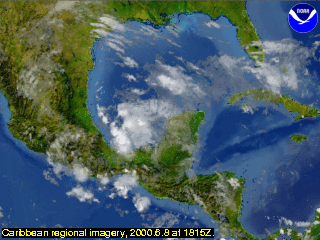
NOAA Satellite and Information Service Home Page NOAA's All Hazards Monitor Where in the World is Tomorrow Now? NOAA National Hurricane Center NOAA Satellite Services Division Geostationary Satellite Server nowCOAST GIS Mapping Portal to Real-Time Environmental Observations and NOAA Forecasts Operational Significant Event Imagery Defense Meteorological Satellite Program NCDC Climate of 2008 FAQ: Hurricanes, Typhoons And Tropical Cyclones Visualization Lab Support | 2000 Regional AnalysesCaribbean AnalysesCaribbean regional imagery, 2000.6.8 at 1815Z.
View our larger 1280 X 960
picture!
Data Elements: Close-up of an unnamed tropical depression at 21.0N 93.5W. Winds are sustained
at 25 kts, gusting to 35 kts.
Observation Device: GOES East 4-km, infrared imagery.
Visualization Date: August 16, 2002 16:01:49
|


