| 1450 |  |
Pancake ice adrift on the Ross Sea |
Ross Sea, Antarctica 1999 January |
1451 |  |
Mount Melbourne near Terra Nova Bay Antarctica. 74 21 S Latitude 164 42 E Longitude. |
Ross Sea, Antarctica 1999 January |
1452 |  |
Royal Society Mountain Range in the Transantarctic Mountains across from McMurdo Sound on Ross Island. 78 10 S Latitude 162 40 E Longitude. |
Ross Sea, Antarctica 1999 January |
1453 |  |
Iceberg drifting in the Ross Sea |
Ross Sea, Antarctica 1999 January |
1454 |  |
Icebergs grounded on Pennel Bank |
Ross Sea, Antarctica 1999 January |
1455 |  |
Icebergs grounded on Pennel Bank |
Ross Sea, Antarctica 1999 January |
1456 |  |
Icebergs grounded on Pennel Bank |
Ross Sea, Antarctica 1999 January |
1457 |  |
Icebergs grounded on Pennel Bank |
Ross Sea, Antarctica 1999 January |
1458 |  |
Icebergs grounded on Pennel Bank |
Ross Sea, Antarctica 1999 January |
1459 |  |
Icebergs grounded on Pennel Bank |
Ross Sea, Antarctica 1999 January |
1460 |  |
Icebergs grounded on Pennel Bank |
Ross Sea, Antarctica 1999 January |
1461 |  |
Pancake ice adrift on the Ross Sea. |
Ross Sea, Antarctica 1999 January |
1462 |  |
Pancake ice adrift on the Ross Sea. |
Ross Sea, Antarctica 1999 January |
1463 | 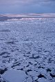 |
Pancake ice adrift on the Ross Sea. |
Ross Sea, Antarctica 1999 January |
1464 |  |
Pancake ice adrift on the Ross Sea. |
Ross Sea, Antarctica 1999 January |
1465 |  |
Pancake ice adrift on the Ross Sea. |
Ross Sea, Antarctica 1999 January |
1466 |  |
Sunset over the Ross Sea. |
Ross Sea, Antarctica 1999 January |
1467 |  |
Pancake ice adrift on the Ross Sea. |
Ross Sea, Antarctica 1999 January |
1468 |  |
The NATHANIEL B. PALMER moving through pancake ice |
Ross Sea, Antarctica 1999 January |
1469 |  |
Nighttime operation of collecting thin sea ice cores for analysis. |
Ross Sea, Antarctica 1999 January |
1470 |  |
Lyttleton Harbor, New Zealand. Home port for the NATHANIEL B. PALMER |
New Zealand 1999 January |
1471 |  |
Hanging out on the bridge of the NATHANIEL B. PALMER |
New Zealand 1999 January |
1472 |  |
Entering Lyttleton Harbor, New Zealand. Home port for the NATHANIEL B. PALMER |
New Zealand 1999 January |
1473 |  |
Recovering a RDI upward-looking Acoustic Doppler Current Profiler near the Ross Ice Shelf |
Ross Sea, Antarctica 1999 January |
1474 |  |
Recovering a RDI upward-looking Acoustic Doppler Current Profiler near the Ross Ice Shelf |
Ross Sea, Antarctica 1999 January |
1475 |  |
Ice on the super structure of the NATHANIEL B. PALMER |
Ross Sea, Antarctica 1999 January |
1476 |  |
Ice on the super structure of the NATHANIEL B. PALMER |
Ross Sea, Antarctica 1999 January |
1477 |  |
The wake of the NATHANIEL B. PALMER in thin sea ice |
Ross Sea, Antarctica 1999 January |
1478 |  |
Thin rafted sea ice |
Ross Sea, Antarctica 1999 January |
1479 |  |
Deploying the Conductivity/Temperture/Depth (CTD) and rosette water sampler through the baltic room door of the NATHANIEL B. PALMER |
Ross Sea, Antarctica 1999 January |
1480 |  |
The Ross Ice Shelf at the Bay of Whales. This is the southern-most navigable point on the planet and the point where Amundsen started his successful trek to the South Pole. 78 30 S Latitude 164 20W Longitude. |
Ross Sea, Antarctica 1999 January |
1481 |  |
The Ross Ice Shelf at the Bay of Whales. This is the southern-most navigable point on the planet and the point where Amundsen started his successful trek to the South Pole. 78 30 S Latitude 164 20W Longitude. |
Ross Sea, Antarctica 1999 January |
1482 |  |
Sea smoke forming towards open water from first year ice at the Bay of Whales. |
Ross Sea, Antarctica 1999 January |
1483 |  |
A bright view from the bridge and of the NATHANIEL B. PALMER |
Ross Sea, Antarctica 1999 January |
1484 |  |
The Ross Ice Shelf at the Bay of Whales. This is the southern-most navigable point on the planet and the point where Amundsen started his successful trek to the South Pole. 78 30 S Latitude 164 20W Longitude. |
Ross Sea, Antarctica 1999 January |
1485 |  |
Sea smoke over open water along the Ross Ice Shelf at the Bay of Whales. 78 30 S Latitude 164 20 W Longitude. |
Ross Sea, Antarctica 1999 January |
1486 |  |
The Ross Ice Shelf at the Bay of Whales. This is the southern-most navigable point on the planet and the point where Amundsen started his successful trek to the South Pole. 78 30 S Latitude 164 20W Longitude. |
Ross Sea, Antarctica 1999 January |
1487 |  |
The NATHANIEL B. PALMER at port in Lyttleton Harbor, New Zealand. |
New Zealand 1997 February |
1488 |  |
Lyttleton Harbor, New Zealand. Home port for the NATHANIEL B. PALMER |
New Zealand 1997 February |
1489 |  |
Statue of Robert Falcon Scott along the Avon River in Christchurch, New Zealand. |
New Zealand 1997 February |
1490 |  |
The NATHANIEL B. PALMER at port in Lyttleton Harbor, New Zealand. |
New Zealand 1997 February |
1491 |  |
The NATHANIEL B. PALMER at port in Lyttleton Harbor, New Zealand. |
New Zealand 1997 February |
1492 |  |
The Wizard speaking in Cathedral Square in Christchurch New Zealand. |
New Zealand 1997 February |
1493 |  |
The NATHANIEL B. PALMER moving through open sea ice. |
Ross Sea, Antarctica 1997 February |
1494 |  |
The NATHANIEL B. PALMER moving through open sea ice. |
Ross Sea, Antarctica 1997 February |
1495 |  |
The NATHANIEL B. PALMER moving through open sea ice. |
Ross Sea, Antarctica 1997 February |
1496 |  |
Bergy bits |
Ross Sea, Antarctica 1997 February |
1497 |  |
Transantarctic Mountains along the western edge of the Ross Sea. 85 S Latitude 175 W Longitude. |
Ross Sea, Antarctica 1997 February |
1498 |  |
Transantarctic Mountains along the western edge of the Ross Sea. 85 S Latitude 175 W Longitude. |
Ross Sea, Antarctica 1997 February |
1499 | 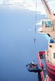 |
Zodiac operations over the side of the NATHANIEL B. PALMER. |
Ross Sea, Antarctica 1997 February |