The Rio Grande flows out of the snowcapped Rocky Mountains in Colorado and journeys 1,900 miles to the Gulf of Mexico. It passes through 800-foot chasms of the Rio Grande Gorge, a wild and remote area of northern New Mexico. The canyon provides a wide variety of recreational opportunities, luring fishermen, hikers, artists, and whitewater boating enthusiasts. In 1968, the Rio Grande and Red River were among the first eight rivers Congress designated into the National Wild and Scenic River System to protect outstanding resources values.
The Rio Grande flows through two BLM developed recreation areas – the Wild Rivers Recreation Area and the Orilla Verde Recreation Area. Click on the links for detailed information on them.
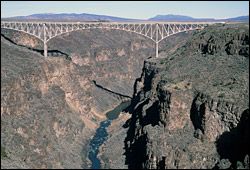
A spectacular vista of the Upper Gorge is from the High Bridge Overlook. The Lower Gorge Area of Critical Environmental Concern covers over 16,000 acres of public land along a 14-mile-long stretch of the Rio Grande from the village of Pilar to the Velarde Diversion Dam.
Activities
Recreation opportunities on the river in New Mexico include biking, boating, camping, fishing, hiking/backpacking, picnicking, wildlife viewing, and horseback riding.
Facilities
Various facilities are available in BLM’s two developed recreation areas along the river – the Wild Rivers Recreation Area and the Orilla Verde Recreation Area. Click on the links for detailed information on them.
Location & Access
Located 6 miles north of New Mexico-Colorado border at Lobatos Bridge and ends at Velarde, New Mexico, 16 miles north of Espanola, New Mexico.
Boating Information / River Segment Descriptions
While there are no boating fees, for safety, BLM requires that boaters register at put-in sites.
Class II to Class V rapids exist in nine different segments encompassing the Upper Rio Grande Gorge and Lower Rio Grande Gorge. Click here for a detailed description of the outstanding segments of the Rio Grande that BLM manages. Following is an overview of some of the segments:
The Upper Gorge includes the Class II Ute Mountain Run (24 miles) and the Class V Upper Box (6.5 miles). It also includes the Taos Box (15 miles), classified Class III-V, which takes 6 to 8 hours, including stops for lunch and sightseeing. The rapids in the Box offer the best whitewater in New Mexico through one of the most scenic sections of the Rio Grande Gorge.
The Lower Gorge begins at the Taos Junction Bridge in the Orilla Verde Recreation Area and extends south for 18 miles. The most popular section is the Racecourse, a 5-mile stretch of whitewater located along NM 68 which offers an exciting ride that is not as demanding as the Taos Box. Trips in the Lower Gorge vary in time from 2 to 6 hours, depending on river flow and where you put in.
River Flow Information
- River Flow Levels -- River flow levels are unpredictable, so boaters should monitor the USGS website, or contact BLM, for current information.
- USGS Water Resource Division - New Mexico District nm.water.usgs.gov.
- BLM 888.882.6188 (Recorded Message).
Planning Your Trip
Many Rio Grande trips are available by arrangement with commercial outfitters, including overnight trips. Most of these require a hike to or from the river and may be seasonally restricted to protect wildlife. Commercial river outfitters are permitted by the BLM to provide trips to the public. All companies meet strict guidelines for equipment safety and guide experience. You may also take your own (or rented) boat down the river. Please review BLM's recommended river safety tips.