Skip Navigation Linkswww.weather.gov 
NOAA logo - Click to go to the NOAA homepage National Weather Service Forecast Office   NWS logo - Click to go to the NWS homepage    
Hanford, California
navigation bar decoration    
 
 
Current Hazards


Current Conditions


Forecasts


Climate


Storm Spotters
 
 
NWS/DOD Sites


Other Weather Info


Weather Safety


Education


Contact Us


  USA.gov is the U.S. government's official web portal to all federal, state and local government web resources and services.
Photo of an orchard in the San Joaquin Valley Photo of the Southern Sierra Nevada Mountains Photo of Red Rock Canyon

Our Service Area

The NWS San Joaquin Valley County Warning and Forecast Area (CFWA) includes a large portion of the central California interior. Our CWFA lies between the crests of the Diablo Range and the Sierra Nevada from Merced and Mariposa Counties south through the Tehachapi Mountains, just beyond Bakersfield. It also includes all of Yosemite National Park and the Kern County portion of the Mojave desert. Elevations vary from only 90 feet above sea level near the Merced County line, to 14,495 feet at the peak of Mt. Whitney (the tallest mountain in the contiguous United States). Our service area includes valley, mountain, and desert climates, divisible into six distinct geographic areas and eleven forecast zones...

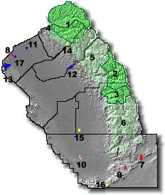
WEST CENTRAL SAN JOAQUIN VALLEY
(Zone 89)
Merced County west of the San Joaquin River and Fresno County west of the San Joaquin and Kings Rivers.
EAST CENTRAL SAN JOAQUIN VALLEY
(Zone 90)
Merced County east of the San Joaquin River; Madera County east of the San Joaquin River and up to the 1000 foot elevation of the Sierra Nevada; Fresno County east of the San Joaquin and Kings Rivers and up to the 1000 foot elevation of the Sierra Nevada.
SOUTHWESTERN SAN JOAQUIN VALLEY
(Zone 91)
All of Kings County; Kern County southwest of a line from the Kings/Tulare/Kern County boundary southeast to Grapevine and up to the 1000 foot elevation of the Tehachapi Mountains.
SOUTHEASTERN SAN JOAQUIN VALLEY
(Zone 92)
Tulare County up to the 1000 foot elevation of the Sierra Nevada; Kern County southeast of a line from the Kings/Tulare/Kern County boundary southeast to Grapevine and up to the 1000 foot elevation of the Sierra Nevada and the Tehachapi Mountains.
MARIPOSA, MADERA, AND FRESNO COUNTY FOOTHILLS
(Zone 93)
Mariposa, Madera, and Fresno Counties between the 1000 foot and the 4000 foot elevation of the Sierra Nevada. HNX CWA
TULARE COUNTY FOOTHILLS
(Zone 94)
Tulare County between the 1000 foot and 4000 foot elevation of the Sierra Nevada.
KERN COUNTY MOUNTAINS
(Zone 95)
The Kern County portion of the Sierra Nevada and the Tehachapi Mountains above 1000 feet on the San Joaquin Valley side and above 3000 feet on the Mojave Desert side.
SIERRA NEVADA FROM YOSEMITE TO KINGS CANYON
(Zone 96)
Mariposa, Madera, and Fresno Counties from the 4000 foot elevation and above in the Sierra Nevada.
TULARE COUNTY MOUNTAINS
(Zone 97)
Tulare County from the 4000 foot elevation and above in the Sierra Nevada.
INDIAN WELLS VALLEY
(Zone 98)
Kern County north of the crest of the El Paso Mountains and east of the 3000 foot elevation of the Sierra Nevada on the Mojave Desert side.
SOUTHEASTERN KERN COUNTY DESERT
(Zone 99)
Kern County south of the crest of the El Paso Mountains and east of the 3000 foot elevation of the Sierra Nevada and Tehachapi Mountains on the Mojave Desert side.


Several recreational areas lie within the service area...

National parks
1. Yosemite
2. Kings Canyon
3. Sequoia
National Forests
4. Stanislaus
5. Sierra
6. Sequoia
Parks in HNX CWA
State parks
7. Red Rock Canyon
8. Great Valley Grasslands
9. Tomo-Kahni
State reserves - 10. Tule Elk
State recreational areas
11. McConnell
12. Millerton Lake
13. San Luis Reservoir
State historical parks
14. Wassama Round House
15. Colonel Allensworth
16. Fort Tejon
17. George J. Hatfield


Demographics of the public service/forecast area are as follows, using 1994 census data...

County Population Area (mi2)
Fresno 737,289 6017.9
Kern 617,528 8162.0
Kings 113,089 1391.6
Madera 107,004 2153.4
Mariposa 15,772 1462.9
Merced 194,407 1372.0
Tulare 346,843 4839.4
Yosemite Nat'l Park n/a 1200.0
Total 2,035,226 26,599.2


Most of the economy of the service area is related to agriculture. However, many jobs are related to oil production, forestry, and aerospace. Lemoore Naval Air Station, China Lake Naval Weapons Center, and Edwards Air Force Base are also major employers in the service area.


Webmaster
US Dept of Commerce
National Oceanic and Atmospheric Administration
National Weather Service
San Joaquin Valley Weather Forecast Office
900 Foggy Bottom Road
Hanford, CA 93230-5236

Tel: (559) 584-3752

Disclaimer
Information Quality
Credits
Glossary
Privacy Policy
Freedom of Information Act
About Us
Career Opportunities