Local Drought Information
Last update on Friday, April 10, 2009.
Updated during the first week of each month, or more frequently if conditions warrant.
Summary: DRY CONDITIONS EXPAND ACROSS THE ENTIRE AREA
In the April 7th release of the U.S. Drought Monitor, abnormally dry conditions were indicated across the entire Tri State area.


The U.S. Drought Monitor is a weekly collaborative effort between a number of federal agencies including NOAA/NWS, U.S. Department of Agriculture and the National Drought Mitigation Center.
| Abnormally Dry (D0) - Going into drought: short-term dryness slowing planting, growth of crops or pastures; fire risk above average. Coming out of drought: some lingering water deficits; pastures or crops not fully recovered. |
Moderate Drought (D1) - Some damage to crops, pastures: fire risk high; streams, reservoirs, or wells low, some water shortages developing or imminent, voluntary water use restrictions requested. |
| Severe Drought (D2) - Crop or pasture losses likely; fire risk very high; water shortages common: water restrictions imposed. |
Extreme Drought (D3) - Major crop/pasture losses: extreme fire danger; widespread water shortages or restrictions. |
| Exceptional Drought (D4) - Exceptional and widespread crop/pasture losses; exceptional fire-risk; shortages of water in reservoirs, streams, and wells, creating water emergencies. |
State and Local Actions
No known actions at this time.
Seasonal Drought Outlook
VALID THROUGH June 2009...no drought forecast to develop in the Tri State area. However, the Climate Prediction Center noted that forecast confidence in the Central Plains was low. Given the ongoing dry conditions and a persistent La Nina pattern, the threat of drought development in the next few months cannot be ruled out, particularly in eastern areas.

The image above is compliments of NOAA
Climatological Summary
March 2009
MARCH PRECIPITATION WAS BASICALLY DIVIDED INTO EASTERN AREAS...WHICH
RECEIVED LITTLE TO NO PRECIPITATION...AND WESTERN AREAS WHICH
RECEIVED MODERATE TO HEAVY SNOW AT THE END OF THE MONTH FROM AN
EARLY SPRING BLIZZARD. THE SNOW FELL BASICALLY ALONG AND WEST OF
HIGHWAY 25...WITH THE HEAVIEST AMOUNTS IN EASTERN COLORADO SOUTH OF
THE INTERSTATE. AN INCH OR TWO FELL ALONG HIGHWAY 25 IN PLACES LIKE
COLBY...BUT FURTHER EAST ONLY TRACE AMOUNTS WERE REPORTED. AS A
RESULT...ABNORMALLY DRY CONDITIONS EXPANDED ACROSS THE
REGION...PARTICULARLY IN THOSE AREAS OF EAST OF HIGHWAY 25 WHERE
THREE MONTH PERCENT-OF-NORMALS DROPPED SHARPLY.
.png)
MARCH 2009 RADAR ESTIMATED PRECIPITATION

More precipitation maps are available on the AHPS home page.
Agricultural Impacts
Ag reports will return in the spring
Topsoil
| Region |
Very Short |
Short |
Adequate |
Surplus |
| Northwest KS |
- |
- |
- |
- |
| West Central KS |
- |
- |
- |
- |
| Nebraska |
- |
- |
- |
- |
| Eastern CO |
- |
- |
- |
- |
Subsoil
| Region |
Very Short |
Short |
Adequate |
Surplus |
| Northwest KS |
- |
- |
- |
- |
| West Central KS |
- |
- |
- |
- |
| Nebraska |
- |
- |
- |
- |
| Eastern CO |
- |
- |
- |
- |
Information provided by USDA National Agricultural Statistics Service (NASS).
Soil moisture supply measures how much moisture is present in cropland top soil during the week. Soil moisture is reported as a percentage.
| Very Short - Soil moisture supplies are significantly less than what is required for normal plant development. Growth has been stopped or nearly so and plants are showing visible signs of moisture stress. Under these conditions, plants will quickly suffer irreparable damage. |
Short - Soil dry. Seed germination and/or normal crop growth and development would be curtailed. |
| Adequate - Soil moist. Seed germination and/or crop growth and development would be normal or unhindered. |
Surplus - Soil wet. Fields may be muddy and will generally be unable to absorb additional moisture. Young developing crops may be yellowing from excess moisture. |
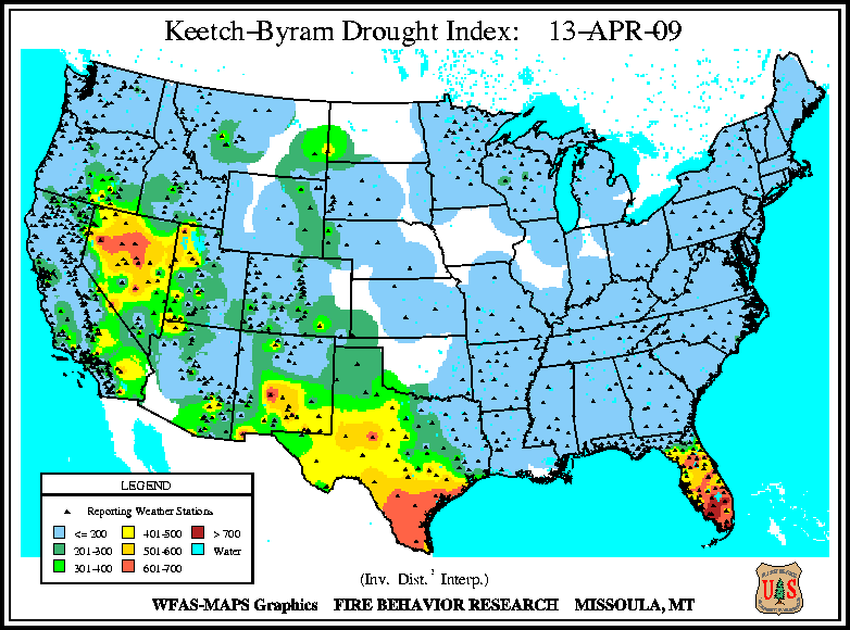
Fire Danger Hazards  The image above is the Keetch-Byram Drought Index and is designed specifically for fire potential assessment. It is a continuous index, relating to the flammability of organic material in the ground. The image above is the Keetch-Byram Drought Index and is designed specifically for fire potential assessment. It is a continuous index, relating to the flammability of organic material in the ground.
0 to 200. Low- Wet with little danger of fire initiation.
201 to 400. Moderate- Drying occurring with some fire danger.
401 to 600. High- Ground cover dry and will burn readily.
601 to 800. Extreme- Dead and live fuels will burn readily.
Latest Drought Information Statement (text version) |


.png)
