 |
 | |
  | |
|
|
|
|
Fire Island National Seashore
Coasts / Shorelines
|
|
|
|
|
| |
 |
 |
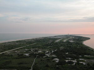
| The lateral movement of sand on Fire Island is evident as you look westward from atop the Fire Island Lighthouse, which was built near the end of the island in 1857. |
 |
Fire Island is a barrier island, which is believed to have developed as a spit of sediment formed from an eroding headland after the end of the last ice age. Its sand comes from two sources: the eroding cliffs and bluffs of Montauk to its east, and from offshore sources which were deposited by retreating glaciers and remain from earlier inlet deltas.
Fire Island's coastline is constantly being shaped and re-shaped by wind and water. Littoral drift, offshore bottom currents, wind, inlet formation, tidal delta growth, and occasional overwash are all essential to maintain a dynamic equilibrium on a barrier island.
|
 |
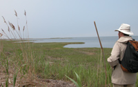
| A back-barrier salt marsh is one of the most productive ecosystems on earth. |
 |
Barrier islands are one of the most common and distinguishable features of the Atlantic coast. These important environments protect the mainland from storm events and wave action, while providing a vital ecosystem for many species. Features such as sand dunes, maritime forests, inlets, lagoons, back-barrier marshes, and vegetation constitute these fragile coastal systems. Without intervention, barrier islands maintain a state of dynamic equilibrium between sediment exchange, wave energy, and sea-level rise.
|
 |
| NPS Natural Resource Program Center | |
 |
For More Information
You can learn more about coastal processes at the NPS "" web site:
- multimedia education program
is one of the critical natural resource issues that concerns the National Park Service. At Fire Island National Seashore, the major repercussion of changing temperatures lies in sea-level rise. The National Park Service and the United States Geological Survey are currently developing Coastal Vulnerability Index (CVI) maps for coastal parks to identify coastal areas sensitive to sea-level rise.
|
|
A series of was published in 2005 to support the preparation of a General Management Plan for Fire Island National Seashore.
|
|  |  |
|
|

Barrier Island Dynamics
A constantly changing shoreline is one of the natural features of Fire Island.
more... | |
|
|
|
|
|
|
|
 |
|
Did You Know?
You can walk to the Fire Island Lighthouse from the Field 5 parking lot at Robert Moses State Park. The lighthouse is open year-round, weather permitting.
more...
|
|
|
|
Last Updated: February 08, 2007 at 22:36 EST |


