|
|
 |
American Samoa · Guam · Puerto Rico/Virgin Islands |
 |
 |
|
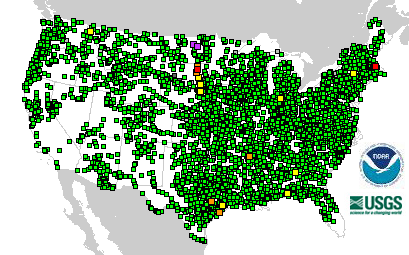
4211 Total Gauges
|
 1 Gauges: Major Flooding 1 Gauges: Major Flooding
|
|
4 Locations in Flood |
 0 Gauges: Moderate Flooding 0 Gauges: Moderate Flooding
|
|
|
 3 Gauges: Minor Flooding 3 Gauges: Minor Flooding
|
 324 Gauges: Observations older than 24 hours 324 Gauges: Observations older than 24 hours
|
 9 Gauges: Near Flood Stage 9 Gauges: Near Flood Stage
|
 16 Gauges: Out of Service 16 Gauges: Out of Service
|
 3858 Gauges: No Flooding 3858 Gauges: No Flooding
|
Last map update: Mon, Aug, 24, 2009 at 09:44:05 pm EDT.
|
|
|

