SPARROW Surface Water-Quality Modeling

    NAWQA Home    Model Description    Fact Sheet    FAQs    Documentation    Software    Publications    Contacts    Training    Regional MRB Studies


SPARROW, a modeling tool for the regional interpretation of water-quality monitoring data. The model relates in-stream water-quality measurements to spatially referenced characteristics of watersheds, including contaminant sources and factors influencing terrestrial and aquatic transport. SPARROW empirically estimates the origin and fate of contaminants in river networks and quantifies uncertainties in model predictions.


Phosphorus Yield in the Mississippi River Basin
  SPARROW tracks nutrient delivery locally
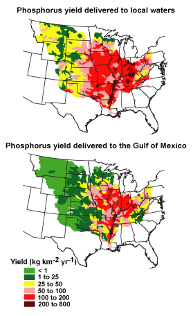
  to the outlets of inland watersheds and
  regionally to coastal waters. Differences
  in phosphorus yield in the Mississippi
  River Basin shown above are caused by
  local and regional differences in phos-
  phorus removal in streams and reservoirs
  during transport [Read more about these
  and other SPARROW results]

  Related Links:
  NAWQA Home Page
  NAWQA Nutrients Synthesis Program
  NAWQA Modeling and Software
  Coastal Hypoxia Research Project
  Denitrification Research Coord. Network
  SPARROW Workshop: October 2002
  SPARROW Internal Web Page


Accessibility FOIA Privacy Policies and Notices

Take Pride in America home page. FirstGov button U.S. Department of the Interior | U.S. Geological Survey
URL: http://water.usgs.gov/nawqa/sparrow/index.html
Page Contact Information: ralex@usgs.gov
Page Last Modified: Friday, 17-April-2009 12:09 EDT