|
|
 |
Assateague Island 1998 Northeaster
| |
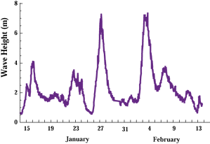
Wave height off Ocean City, MD, January and February
1998. |
During January and February, 1998, while El-Niño storms impacted
the west coast of the U.S., two major northeasters impacted the
mid-Atlantic states. Our partners at NASA Wallops Flight Facility
(Wallops Island, VA) surveyed nearby Assateague Island, a NPS
National Seashore, using scanning airborne laser altimetry
prior to and after two major northeasters that occurred one week
apart. During each storm, wave heights reached 7 m off Ocean City, MD.
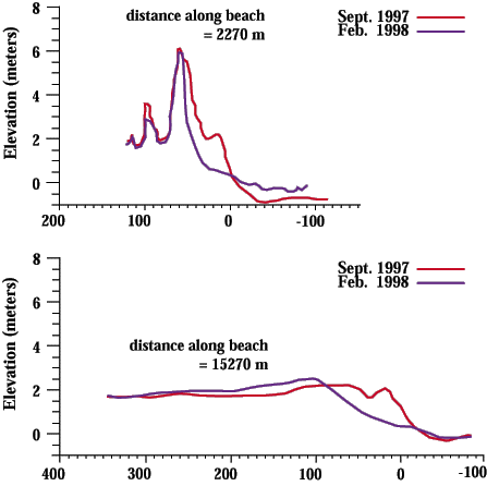
Example profile comparsions derived from the laser altimetry data (see below) show considerable variability of impact on Assateague Island from extensive reteat of coastal dunes to overwash across the island. These profiles consist of all data that lie within 1 m of the shore-normal line. Note the vertical exaggeration that emphasizes the changes.
In February 1998, a major winter storm, or 'northeaster', severely impacted Assateague Island National Seashore. Offshore significant wave heights were approximately 7 meters. Impacts along the island were highly variable and suggested the occurrence of the collision and overwash regimes.
Below left is an infrared satellite photograph of the Assateague Island National Seashore, including oblique aerial photographs from selected locations along the shore.
To the right of the satellite image and the photographs is the lidar Storm Impact/Recovery graph. The graph has been aligned with the satellite image of the island for location reference. In places, the shoreline eroded over 80 meters (red line). However, the amount of change varied greatly along the coast. Within several months the shoreline had substantially recovered (blue line). A major research objective is to determine what causes this spatial variability along the coast.
|


