|
|
Highlights !!!
NEW PUBLICATION:
USGS Professional Paper 1750:
A Volcano Rekindled: The Renewed Eruption of Mount St. Helens, 2004-2006
-- Sherrod, D.R., Scott, W.E., and Stauffer, P.H. (editors), 2008.
Mount St. Helens began a dome-building eruption in September 2004 after nearly two decades of quiescence. Dome growth was initially robust, became more sluggish with time, and ceased completely in late January 2008. The volcano has been quiet again since January 2008. Professional Paper 1750 describes the first 1½ years of this eruptive activity, chiefly from September 2004 until December 2005. Its 37 chapters contain contributions of 87 authors from 23 institutions, including the U.S. Geological Survey, Forest Service, many universities, and local and State emergency management agencies. Chapter topics range widely—from seismology, geology, geodesy, gas geochemistry, and petrology to the human endeavor required for managing the public volcanic lands and distributing information during the hectic early days of a renewed eruption.
Read More About It
|
|
Q: How big is the new lava dome ???.
The volume of the new lava dome as measured July 5, 2007, was 122 million cubic yards (volume is equivalent to 150 to 200 large sports stadiums) and was growing at an average rate of 0.14 cubic yards per second (nearly equivalent to filling 4 Olympic-sized swimming pools every day.
[Information release, February 21, 2008]
[More]
|
News
Eruption
Photo Gallery
Features and Information
New Online
- NEW Professional Paper released:
A Volcano Rekindled: The Renewed Eruption of Mount St. Helens, 2004-2006
[April 5, 2009]
-
NEW images of toe of the west arm of Mount St. Helens' Crater Glacier taken on March 12, 2009, as seen from Sugar Bowl ... includes comparision images from May 2008 and May 2007
[March 25, 2009]
-
NEW image of toe of the west arm of Mount St. Helens' Crater Glacier, as seen from Sugar Bowl, and NEW comparision images from May 2008 and February 2007
[December 8]
- New Mount St. Helens' time-lapse of dome growth, as seen from the Sugar Bowl remote camera, from November 10, 2004 through February 28, 2008.
[November 14]
NOTE: LARGE FILES ...
["MOV" format, 34M] ...
["MP4" format, 34M]
-
ARCHIVES
Background Information
-
Alert Levels for the Cascade Range Volcanoes - Information
-
Aviation Color Codes
-- Alaska Volcano Observatory's "Level-of-Concern" Color Code, USGS Fact Sheet FS030-97
-
Glossary of Volcano Terminology
-
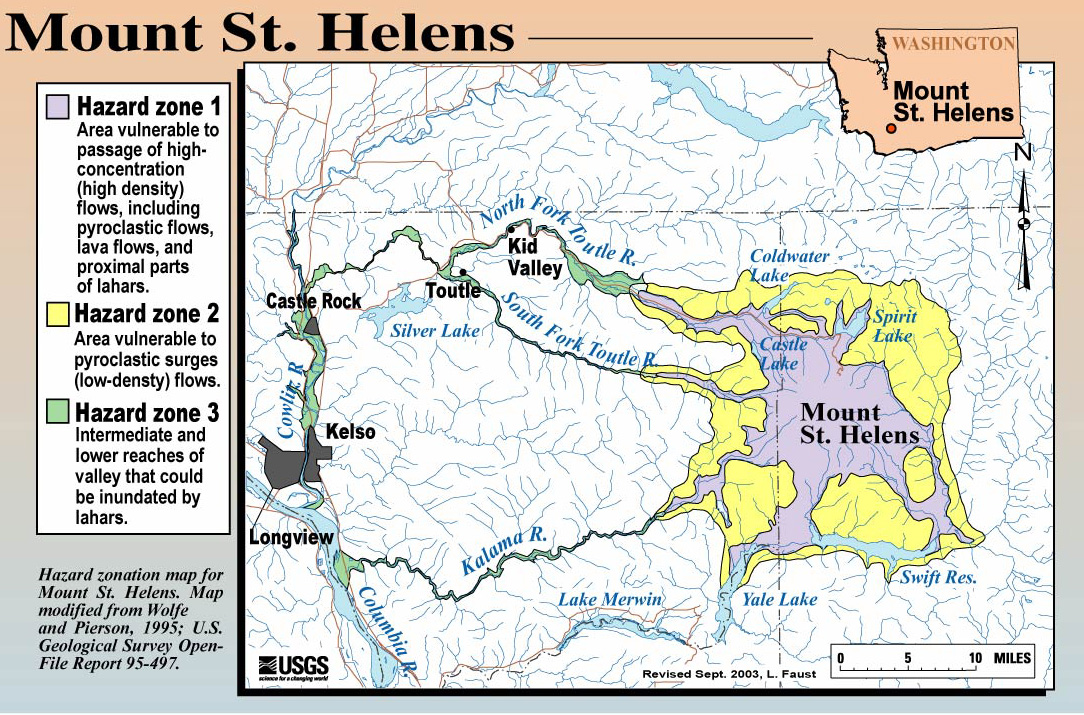
Hazards Map - Mount St. Helens Hazards Zones
-- [regional, large-scale, JPG Format, 467K, 1084x715pixels]
-
Hazards Report - Volcanic-Hazard Zonation for Mount St. Helens, Washington, 1995, USGS Open-File Report 95-497
-- Current Hazards Report
-
LIDAR
-
Location Map - Cascade Range Volcanoes
-
Location Map - Mount St. Helens
-
Media Advisory - Interior Secretary Gale Norton visit, October 2, 2004
-- [PDF Format]
-
Mount St. Helens -- From the 1980 Eruption to 2000, USGS Fact Sheet FS036-00
-
Mount St. Helens Erupts Again --
Activity from September 2004 through March 2005, USGS Fact Sheet FS2005-3036
-
Past Updates, Advisories, and Information Statements for the Cascade Range
-
Past Updates, Advisories, Information Statements, and Monthly Seismic Graphs for Mount St. Helens
-
Seismic Signal Examples -- including a small gas and ash explosion
-- [PDF Format, 915K]
-
U.S. Geological Survey’s Alert Notification System for Volcanic Activity
-- Gardner and Guffanti, 2006, USGS Fact Sheet 2006-3139
-
Volcanic Ash Website -- "What it can do and how to prevent damage"
-- Link
-
Volcanic Explosivity Index (VEI) information
-- [PDF Format, 1.4M]
Other Menus of Interest
|
|
