Reducing Ship Strikes to North Atlantic Right Whales
|
Dynamic Management Areas (DMA) Mariners are expected, but not required, to either avoid DMAs or travel through them at 10 knots or less. There are no DMAs in effect at this time. |
|
Seasonal Management Areas (SMA) The following SMAs [pdf] are in effect at this time:
Northeast SMA |
Related Links North Atlantic Right Whales |
|
|
|
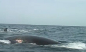 North Atlantic Right Whale (video) (Eubalaena glacialis) Photo: NOAA  North Atlantic Right Whale (video) (Eubalaena glacialis) Photo: NOAA 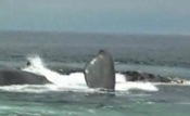 North Atlantic Right Whale (video) (Eubalaena glacialis) Video: WCSH6, Portland, ME |
|

Speed Restrictions in Effect to Reduce the Threat of Ship Collisions with North Atlantic Right Whales
NMFS has established regulations to implement a 10-knot speed restriction for all vessels 65 ft (19.8 m) or longer in certain locations along the east coast of the U.S. Atlantic seaboard at certain times of the year. The purpose of the regulations is to reduce the likelihood of deaths and serious injuries to endangered North Atlantic right whales that result from collisions with ships.
- Federal Register Notice [pdf]
(Published 10/10/2008, 73 FR 60173)- OMB Approval of Collection-of-Information Requirements [pdf]
(Published 12/5/2008, 73 FR 74003)
- OMB Approval of Collection-of-Information Requirements [pdf]
- Press Release on Effective Date of Speed Regulations [pdf]
- Compliance Guide for Mariners [pdf]

- Fact Sheet [pdf]
- Map of Seasonal Management Areas [pdf]
- Right Whale Fact Sheet [pdf]
- Record of Decision [pdf]
- Press Release on Final Rule [pdf]
- Right Whale Videos and Photos
Final Environmental Impact Statement (FEIS) to Implement the Vessel Operational Measures to Reduce Ship Strikes to the North Atlantic Right Whale
NOAA Fisheries issued regulations to reduce the likelihood of ship collisions with right whales. The Final Environmental Impact Statement (FEIS) identified and assessed alternatives for the regulations. The FEIS includes analysis of environmental and economic impacts of the alternatives. The public comment period closed on September 29, 2008.
- Press Release [pdf]
- Final Environmental Impact Statement (FEIS) [pdf] [24.7 MB]
- The FEIS is also available for download by chapter.
- Economic Analysis for the FEIS [pdf] [1.3 MB]
- Appendices to the Economic Analysis [pdf] [3.0 MB]
- Federal Register Notice of Availability [pdf]
(Published 8/29/2008, 73 FR 50962) - FEIS Fact Sheet [pdf]
- Map of Areas Included in FEIS [pdf]
Routing Measures
Shift of the Boston Traffic Separation Scheme
On July 1, 2007, NOAA and the USCG implemented a shift in the Traffic Separation Scheme servicing Boston to reduce the threat of vessel collisions with right whales and other whale species. The realignment is expected to result in a 58% reduction in the risk of ship strikes to right whales, and an 81% risk reduction in ship strikes of other large whale species occurring in the area. The U.S. government submitted a proposal to the International Maritime Organization to modify the shipping lanes in April 2006, which was approved in December 2006.
- Press Release [pdf]
- Proposal to the International Maritime Organization (IMO) on Shifting the Traffic Separation Scheme (TSS) into Boston [pdf]
- U.S. Coast Guard Port Access Route Study (PARS) [pdf]
- The Boston TSS is charted on NOAA Print-on-Demand Charts and NOAA Raster Navigational Charts.
- Federal Register Notice of Port Access Route Study (PARS) of area south and east of Cape Cod Bay [pdf]
(Published 11/19/2007; 72 FR 64968)
Recommended Shipping Routes
In November 2006, NOAA established a set of recommended vessel routes in four locations to reduce the likelihood of ship collisions in key right whale habitats.
NOAA, USCG Provide Commercial Mariners with Free Interactive Guide to Right Whale Protection
- Press Release [pdf]
Additional Supporting Documents
- United States' Actions to Reduce the Threat of Ship Collisions with Large Whales (June 2008 IWC) [pdf]
- Large Whale Ship Strike Database [pdf] [3.3 MB]
Jensen, A.S. and G.K. Silber. 2003. NOAA Tech Memo NMFS-OPR-25. - Characterization of Ship Traffic in Right Whale Critical Habitat [pdf] [588 KB]
- Simple analyses of ship and large whale collisions: Does speed kill? [pdf]
- Applying a Spatial Model to Evaluate the Risk of Interactions Between Vessels and Right Whales in the Southeast U.S. Critical Habitat [pdf] [4.4 MB] L.P. Garrison, 2005.