National Park Service LogoU.S. Department of the InteriorNational Park ServiceNational Park Service
National Park Service:  U.S. Department of the InteriorNational Park Service Arrowhead
Knife River Indian Villages National Historic SiteSakakawea Village
view map
text size:largestlargernormal
printer friendly
Knife River Indian Villages National Historic Site
Nature & Science
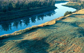
Sakakawea village site along the Knife River.  Notice earthlodge impression along grass river banks.
Sakakawea village site along the Knife River. Notice earthlodge impression along grass river banks.
The Knife River meanders along through Mercer County, North Dakota arriving at the confluence of the Missouri River near Stanton. Park land borders both sides of the rivers creating a forested peninsula throughout part of the park. The rest of the park’s 1759 acres are within a few hundred yards of these water sources. In 1974, the site was established to preserve certain historic and archeological remnants of the culture and agricultural lifestyles of the Plains Indians. The area is comprised of native short grass prairie, exotic grasslands, 450 acres of hardwood forest, cultural village sites and even some sandbars and wetland areas.
sunflower head  

Did You Know?
Along with a fully furnished earthlodge, the park also has a garden that grows traditional crops; including blue flint corn, Hidatsa red beans, and multi-headed Maximilian sunflower seeds.

Last Updated: July 25, 2006 at 00:22 EST