
ANSS - Advanced National Seismic System
Products & Services
-
Recent Earthquakes
 Automatic maps and event information are available within minutes oniline at the Earthquake Hazards
Program website which displays earthquake locations nationwide.
Automatic maps and event information are available within minutes oniline at the Earthquake Hazards
Program website which displays earthquake locations nationwide.
-
Did You Feel It?
 Human reports of shaking. Report your earthquake experience and see the map of shaking reports.
-
ShakeMap
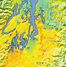 Instrumentally measured shaking intensity mapped in a certain region. Fast information on strong skaing
in urban areas helps get emergency response to the right places.
Instrumentally measured shaking intensity mapped in a certain region. Fast information on strong skaing
in urban areas helps get emergency response to the right places.
-
Hazard Maps
 Hazard mpas identify the areas of the country that are mostly likely to experience strong shaking in the future.
Zip code or latitude-longitude lookup is available.
Hazard mpas identify the areas of the country that are mostly likely to experience strong shaking in the future.
Zip code or latitude-longitude lookup is available.
-
Earthquake Notification
 Automated notifications of earthquakes through e-mail, pager, or cell phone. Rapid information and updates to
first responders, and resources for media and local government.
Automated notifications of earthquakes through e-mail, pager, or cell phone. Rapid information and updates to
first responders, and resources for media and local government.
-
CISN Display
 Graphically alerts users, in near real-time, of seismicity as well as vital earthquake-hazards information following a significant earthquake.
 -
Earthquake Catalog & Data
 Online catalog search and downloadable information and technical data.
-
Real-time Waveforms
 Real-time waveform displays from 60 stations are available online 24 hours a day.
-
Earthquake Info by Region
 Information about earthquake hazards, historical seismicity, faults, and more is available for
different regions of the country and by State.
Information about earthquake hazards, historical seismicity, faults, and more is available for
different regions of the country and by State.
-
Movies of Structures Shaking
 Quicktime movies created from the recordings of fully-instrumented structures during earthquakes.
