
The Small Wetlands Program:
|
 |
| Ducklings in nest |
| Credit: USFWS Your purchase of a Federal Duck Stamp has helped to permanently protected nearly three million acres of wildlife habitat on Waterfowl Production Areas. |
Before attempting to explain all the legislative, programmatic and funding details of the U.S. Fish and Wildlife Service’s Small Wetlands Program, here’s what you need to know about the most effective conservation program you’ve likely never heard of: the Small Wetlands Program uses funds from the sale of Federal Duck Stamps to permanently protect some of the most threatened and productive migratory bird habitat in the United States.
Since its creation 50 years ago, the program has protected nearly three million acres of habitat, mainly in the Prairie Pothole Region of the United States. These protected areas are called waterfowl production areas, and they are part of the National Wildlife Refuge System.
While the Small Wetlands Program is arguably one of the most effective and efficient conservation programs in the history of the United States, it is also a marketing nightmare. It has a complex and sometimes confusing legislative history, its funding comes from multiple sources, and numerous Service programs play a role in its operation.
In addition to the complicated bureaucracy above the program, the program itself includes many subsets. Waterfowl productions areas, wetland management districts, wetland acquisition offices, and habitat and population evaluation teams are just a few of components that keep this program running.
The History
The impetus for developing the Small Wetland Program began in the 1940s when Waubay National Wildlife Refuge Manager Fred Staunton began documenting significant reductions in waterfowl populations. Staunton, and many others, believed these reductions were the direct result of massive wetland drainage programs across America’s prairie.
In an April 1949 article in Field & Stream magazine titled “Good-By Pot-Holes,” Clay Schoenfeld brought the plight of waterfowl and the loss of wetlands to the attention of the rest of America. As a result of this raised awareness, Congress acted to permanently protect waterfowl habitat in the Prairie Pothole Region, which encompasses lands in the upper Midwest.
Congress officially created the Small Wetland Program on Aug. 1, 1958, by amending the 1934 Migratory Bird Hunting and Conservation Stamp Act (commonly referred to as the Duck Stamp Act) to allow proceeds from the sale of Federal Duck Stamps to be used to protect waterfowl habitat. The habitat protected through the Small Wetland Program consists of small wetlands, and surrounding grassland habitat, primarily in the U.S. portion of the Prairie Pothole Region. These areas, protected in perpetuity through fee-title acquisition or easement, are called waterfowl production areas (WPA).
Beginning in the late 1950s, Service realty specialists began crisscrossing the Prairie Pothole Region working with willing landowners to protect remaining waterfowl habitat. In 1959, the Service acquired its first WPA, the McCarlson WPA in Day County, S.D. Congress recognized the success and understood the importance of the program, and in 1961 greatly increased the program’s funding by approving the Wetland Loan Act.
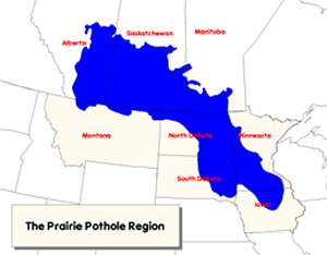 |
| Prairie pothole region |
| Credit: USFWS |
Prairie Pothole Region
The Prairie Pothole Region of North America was once the greatest expanse of grasslands and small wetlands on earth. The southern reach of the region is in central Iowa and it extends northwest through Minnesota, South Dakota, North Dakota, Montana and into Canada.
Before a massive network of agricultural drain tiles were installed under the fertile soil, the area was covered with small wetlands called prairie potholes, created when glaciers advanced and retreated over the area. The original density of small wetlands across the region averaged an astonishing 83 wetland per square mile.
Because of these small—often seasonal—wetlands, and the grasslands associated with them, the Prairie Pothole Region is an ideal nursery for waterfowl and has long been called the “Duck Factory” of North America.
Even today, with much of the wetlands and grasslands of the Midwest converted to agriculture, and just 2 percent of the land base part protected within the National Wildlife Refuge System, the Prairie Pothole Region still produces 50 percent of North America’s breeding waterfowl population.
Waterfowl Production Areas
Waterfowl production areas are wetlands, and the surrounding uplands, that provide breeding, resting and nesting habitat for millions of waterfowl, shorebirds, grassland birds and other wildlife. WPAs also protect native plants, provide habitat for resident and migratory wildlife, help filter groundwater, control runoff and flooding, and capture carbon from the atmosphere.
With more than 36,000 separate fee and permanent easement tracts covering nearly three million acres, waterfowl production areas account for 18 percent of National Wildlife Refuge System lands in the lower 48 states. Approximately 95 percent of these WPA lands are located within the Prairie Pothole states of North Dakota, South Dakota, Minnesota and Montana. Fact Sheet on Waterfowl Production Areas (223 KB PDF)
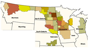 |
| Map of Wetland Management Districts |
| Credit: USFWS |
Wetland Management Distrticts
To help effectively manage the increasing number of waterfowl production areas, in 1962 the Service created an administrative organization called a wetland management district (WMD). In addition to actively managing all the WPAs in a multi-county area, wetland management districts also work closely with the private landowners, government and nongovernment organizations, businesses and other federal agencies in their districts to improve wildlife habitat.
As part of the National Wildlife Refuge System, WPAs are generally subject to the same rules, regulations and requirements of a national wildlife refuge. “Basically we’ve got 244 refuges, with a more than 500 miles of border, spread across eight counties to manage,” says Morris Wetland Management District Manager Steve Delehanty. “The increased number of adjacent landowners can be a challenge, but it also really helps us develop working relationships with a large portion of the community, and this is an opportunity to work on conservation on a landscape scale.”
The most prominent difference between refuges and WPAs is that all fee-title owned WPAs are automatically open to hunting unless there is a reason, such as public safety, that hunting should not be allowed. Map of all Wetland Management Districts (1.29 MB PDF)
The Future
While the Small Wetland Program is taking some time during its 50th anniversary celebration to reflect on all that has been accomplished, the main reason for celebrating is to raise awareness of the program and guide it toward another successful 50 years.
The Prairie Pothole Region continues to face many challenges today, just as it did in the 1940s. Wetlands are still being drained and grasslands are being plowed under. Increased grain prices and modern agricultural practices create incentives to put marginal farm land into agricultural production. Land prices have increased rapidly and because of this the Service is often unable to protect valuable wildlife habitat.
Despite this seemingly complicated program with complicated challenges, there’s one thing you really need to know. If you’re asking yourself, “How can I help make the Small Wetland Program a success during the next 50 years?,” the answer says it all: Buy a Federal Duck Stamp and tell all your friends to do the same.