|
Research Project:
SNOW AND HYDROLOGIC PROCESSES IN THE INTERMOUNTAIN WEST
Location: Northwest Watershed Research Center
Project Number: 5362-13610-008-00
Project Type:
Appropriated
Start Date: Jan 14, 2007
End Date: Jan 13, 2012
Objective:
1) Conduct detailed field experiments to quantify how fluxes of water and energy control snow accumulation and melt, and affect soil moisture, streamflow, and water supplies in western watersheds.
2) Develop methodology for detailed characterization of terrain and canopy structure over mountainous regions using high resolution LiDAR data.
3) Develop improved coupling of surface and below-ground models for spatial simulation of snowmelt, runoff, soil temperature and moisture, and streamflow.
4) Develop methodology for generating cold-season runoff distributions to improve RUSLE erosion predictions in agricultural regions dominated by winter snow and frozen soil.
5) Test and validate new instrumentation, databases, and model interfaces for use by the NRCS and other action agencies and potential users.
Approach:
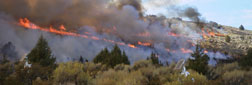
(1) Five Eddy Co-variance systems will be deployed across a range of landscape and vegetation types to measure atmospheric fluxes over vegetation and snow. Within and above canopy radiation exchange, simulated by the SHAW model, will be tested using solar and long-wave radiation data collected for a variety of plant canopies (wheat, soybean, maize, and forest). ETRS integrated flux measurement systems will be established to accurately measure fluxes from the bedrock to the atmosphere. (2) LiDAR data will be acquired over a large area of southwestern Idaho, including RCEW, the Boise Front, and the Juniper Impact area of the Owyhee Mts. A voxel-based canopy model will be developed to estimate canopy transmissivity to direct and diffuse solar radiation and thermal radiation enhancement due to canopy emissivity and heating effects. The simulations will be validated against detailed sub-canopy radiation and canopy temperature measurements completed as part of Objective 1. (3)a. Detailed models of snow deposition, redistribution and melt, including adjustments for canopy effects will be scaled from plots the relatively small Reynolds Mountain, Upper Sheep Creek and Johnston Draw catchments and then scaled to the much larger Tollgate sub-basin. b. A spatially distributed soil water model will be used to simulate streamflow generation and plant water use for two water years for which extensive data have been collected. c. The hydrologic effects of fire will be evaluated at the Upper Sheep Creek catchment comparing historical, pre-fire data and validated modeling to and measured data and simulations following prescribed fire. (4) The SHAW model will be modified as necessary to accurately simulate frozen soil runoff. The model will then be applied for a series of climate and crop/residue cover scenarios to generate a distribution of runoff events to assess the influence of crop/residue cover on cold-season runoff to be incorporated in the RUSLE erosion model. (5) A state-of-the-art hydrological relational database that enhances user data accessibility will be developed and populated, the ISNOBAL snow accumulation and melt program will be incorporated into the NRCS OMS modeling system, and there will be continued work on snow water equivalent and soil water content measuring devises in cooperation with the NRCS.Replaces 5362-13610-006-00D (1/07).
|
|
|
|