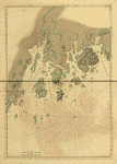
[Coast of Maine from Frenchmans Bay to Mosquito Harbor].
Joseph F. W. Des Barres, [S.l.], 1776.
From Atlantic Neptune Collection, no. 844.
Mapping the American Revolution and Its Era
An engraved view of a sea drama published in the early editions of The Atlantic Neptune, the principal maritime atlas of the American Revolution, shows a British merchant ship foundering in a storm. The vessel is careening sharply on its port side with its main mast broken. Most of its sails have been blown away, and already part of its cargo is awash. Lifeboats from two sister ships, newly arrived on the scene, are attempting to reach the merchantman, but its glistening, windswept deck holds not a sign of life.
|
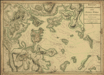
[Coast of Maine from Frenchmans Bay to Mosquito Harbor].
Joseph F. W. Des Barres, [S.l.], 1776.
From Atlantic Neptune Collection, no. 844. |
In the eighteenth century such tragedies were frequently acted out in life as well as on canvas. The purpose of the engraved view in the opening pages of The Atlantic Neptune was to catch the attention of mariners bound for North America--who shared a common dread of shipwreck in these uncharted waters--in the hope that they would read the accompanying note. Under the caption "Utility of the Atlantic Neptune," the author, Joseph Frederick Wallet Des Barres, described example afer example in which individual ships and entire squadrons avoided certain disaster off the American coast through the use of his charts and plans.
Unfortunately, Des Barres's claims for the necessity of his charts were not exaggerated. Until the appearance of The Atlantic Neptune in 1777 (individual plates were available in increasing numbers starting in 1774), the most popular guide to navigation in North America was The English Pilot, from which charts were reproduced throughout the eighteenth century with few corrections or improvements. In fact, the publishers of The English Pilot waited until 1775, when the demand for better charts of the New England coast threatened the sales of their atlas, to include more detailed charts from Cyprian Southack's New England Coasting Pilot, which appeared about 1730. With few charts in The English Pilot based on actual surveys, mariners lacked essential information on tides, currents, channels, depth of water, landmarks, and various navigational hazards such as sunken ships and submerged rocks and shoals. Remote areas such as Sable Island and the Bermuda Isles became virtual graveyards for ships, and vessels reaching these shores sometimes drifted back and forth along the coast for weeks before a local pilot could bring them safely to port.
During the first half of the eighteenth century, the quality of maps of the interior parts of North America was as poor as, if not poorer than, the quality of sea charts. Most such maps were drawn on a small scale, often 1:50,000,000, and they featured chiefly the major towns, harbors, and rivers, together with a few roads, trails, and frontier forts, and the hunting ground of the principal Indian tribes. As a special attraction, map publishers sometimes included gold and silver mines, though these were seldom located in areas that could be reached. Provincial and national boundaries rarely followed actual surveys. Most rivers were still uncharted and their courses misrepresented, and in many instances mountains simply filled blank spaces. The great Northwest, as yet unexplored by Europeans, was often left blank on maps of the entire continent, though occasionally the area was taken up by the fabled "Inland Sea," the long-sought water route to the Pacific.
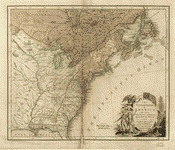
A map of the British and French dominions in North America... John Mitchell, [London]; Sold by And: Millar, 1755.
British and American plenipotentiaries consulted John Mitchell's map of the British
colonies in North America in the peace negotiations resulting in the Treaty of Paris (1783).
The map was also a primary source of information in the Webster-Ashburton treaty negotiations sixty years later. |
In the decade of the 1750s, however, several landmark maps appeared. In 1751 Joshua Fry and Peter Jefferson published the results of their surveys in the middle and Southern colonies in a A map of the inhabited part of Virginia containing the whole Province of Maryland, Part of Pensilvania, New Jersey, and North Carolina. Then in 1755 Lewis Evans's A General Map of the Middle British Colonies and John Mitchell's A Map of the British and French Dominions in North America were published, winning each man almost instant acclaim. Evans's map proved so popular that it was pirated sixteen times before the turn of the century, and Mitchell's map, which is considered one of the most important documents in American history, was consulted by plenipotentiaries for both sides in the peace negotiations of 1782 and 1783. William DeBrahm followed Evans and Mitchell with his map of South Carolina and Georgia, a work that eventually gained him the appointment of Surveyor General of the Southern District of North America. There were also several important surveys in progress in the northern provinces in the 1750s, most notably in the St. Lawrence River Valley under the direction of Samuel Holland and J. F. W. Des Barres.
The reasons for the increased interest in North American geography and the tremendous improvements in the quality of maps of the eastern half of the continent are not hard to find. By mid-century Great Britain and France once again faced the prospect of war over their territorial claims in the Americas. As in all such struggles, the demand for maps of the war zone increased. In the early 1750s this demand was met by copyists and propagandists. In France, for example, map publishers such as Jean Baptiste Nolin and Maurille Antoine Moithey took advantage of the situation to produce maps that favored French claims and denoted the "pretentions des Anglois," and in England mapmakers such as John Lodge, Robert Sayer, and Emanuel Bowen highlighted the "French Encroachments" in North America for the English-speaking world. The most outspoken anti-Gallicans, such as William Hebert, even asserted that the boundaries shown on their maps of North America were confirmed by charters and the formal surrender of England's "Indian friends."
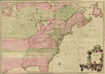
The United States of America laid down from the best authorities, agreeable to the Peace of 1783.
John Wallis, London, 1783.
John Wallis was one of the first mapmakers to show the new territory of the United States as defined by the Treaty of Paris (1783).
Although the map is dated April 3, 1783, the treaty was not signed until the following September. |
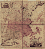 A map of the most inhabited part of New England...
Thomas Jefferys, [London] Thos. Jefferys, 1755.
Thomas Jefferys obtained a vast amount of information on land claims for his popular map of the most inhabited part of New England,
but his poor representation of the New England coast highlighted the need for the official survey later undertaken by Samuel Holland. |
Obviously, once the French and Indian War was underway, there was a ready market in Great Britain and France for campaign maps, siege and battle maps, maps showing the entire theater of war, propaganda maps, and public information maps. And after the signing of the Treaty of Paris in 1763, the cry came for maps outlining the territorial settlements of both countries.
As for the improvements in the quality of maps produced during this period, one has only to look at the new techniques employed by leading surveyors. Des Barres explained his technique for charting American waters as follows:
I measured a base of 350 fathoms along a plane on the western side of Exeter Harbour, and from its extreemities [sic], having, with a theodolite, taken the angles of visual rays to objects placed on the opposite shore, which being calculated trigonometrically and protracted in their proper bearings, on paper fixed upon a plain table, I then repeated, with the plain table, the same operations over again, and intersected the same objects from the same extreemities of the base line, by which and other intersections, or series of triangles, I had the distance between an object placed on Point Bulkeley and another on Newton Head; from whence, by further intersections performed in the same manner, I determined the true emplacement of Winter's Roger's and Barron's Islands, and of all the ledges; thence, repeating the former operations from all these islands, I found all the angles, and distances to agree with what I had layd down, from the above mentioned observations, before. From points as were most commodiously situated on those island, and head lands, I observed the distance head lands, bays island points, and other remarkable objects, as far as they could be distinguished. Next I went along shore, and reexamined the accuracy of every intersected object, delineated the true shape of every head land, island, point, bay, rock above water, etc., and every winding and irregularly of the rocks and breakers, determined from extent, as perfectly as I could. When the map of any part of the coast was completed in this manner, I provided immediately each craft with copys of it; The sloop was employed in beating off and on, upon the coast, to the distance of ten and twelve miles in the offing, laying down the soundings in their proper bearings and distance, remarking every where the quality of the bottom. The shallop was, in the meantime, kept busy in sounding, and remarking around the headlands, island, and rocks in the offing; and the boats within the indraught, upwards, to the heads of bays, harbors, etc.
Des Barres, like numerous other British engineers and surveyors sent to America to assist in the war effort, had been trained in the latest surveying techniques, and unlike his predecessors, he was able to make precise measurements of vertical and horizontal angles with the theodolite, a relatively new instrument. The troublesome problem of determining longitude had also been solved with the invention of the chronometer about 1730.
British and French military engineers and surveyors produced many excellent maps and charts of North America and the West Indies during the French and Indian War, but the British held a decided advantage, in part because of their strategic position, and quickly surpassed the French in the production of new maps. Not only did France lose its supremacy in the area of sea charts, but its mapmakers in Paris were soon copying the works of London printers. The most notable cartographic work done during the war took place in Nova Scotia, the St. Lawrence River Valley, northern New York, the Carolinas, and parts of the West Indies. However, to the surprise of many, the most vigorous mapping effort of the century took place after the signing of the Treaty of Paris in 1763.
The French and Indian War awakened the British government to the need for better maps of its North American empire, and with the advent of peace, a program was established for mapping the entire Eastern seaboard. To accomplish this, the colonies were divided north and south at the Potomac River and a surveyor general appointed for each district--William DeBrahm for the Southern District. An expedition was also sent to chart the course of the Mississippi River with a view to gaining access to the Gulf of Mexico for frontier traders. Extensive plans were even drawn for linking the Mississippi and Iberville rivers to bypass the Isle of Orleans and reach the Gulf through Lake Pontchartrain, the southern boundary of Britain's North American territory. Additionally, the British Admiralty gave desultory support to a program for charting the St. Lawrence River, Nova Scotia, New Brunswick, and parts of New England. These surveys produced remarkable results. Des Barres charted the entire coast of Nova Scotia and parts of New Brunswick and New England. His chart of Sable Island was two years in the making, but well worth the effort. In 1774 he returned to England to edit and publish his charts. Samuel Holland worked with teams of surveyors to produce maps of Prince Edward Island, Cape Breton, and the inhabited parts of Canada and New England. His name is also used in connection with maps of New York and New Jersey. As instructed, De Brahm concentrated his efforts on the Florida peninsula south of St. Augustine. His were the first scientific surveys of the peninsula, which heretofore appeared on most maps of the area as a collection of narrow islands, and he produced the first printed map of the Gulf Stream.
The disturbances culminating in the War of American Independence prevented Holland from completing his survey of the Northern District of North America, but the information already acquired proved invaluable in Britain's war effort. So desperate was the British Navy for detailed surveys of the New England coast that Des Barres printed many of his charts before they were half finished. Some lacked titles and topographic features. Others were mere outlines of small sections of the coast. In an effort to extend the coverage of his atlas, Des Barres compiled and edited the surveys of Holland, DeBrahm, and others, but he eventually compromised the quality of his work by inserting siege and battle maps, some of which possessed little or no nautical value.
Boston, its environs and harbour, with the rebels works raised against that town in 1775... Sir Thomas Hyde Page, [1775?].
Lt. Thomas Hype Page's plan of the siege of Boston is informative on the disposition of troops and fortifications,
but Page was much too casual in his representation of the Massachusetts coast. |
Most maps drawn during the war reflect the exigencies of the struggle. Occasionally, a campaign map will be found imposed on a carefully executed map from an earlier period, but the majority are technically poor. Among the maps drawn in America, the exceptions are the ones that were drawn over a period of weeks or months such as during a lengthy siege or winter encampment. By far the worst examples are maps by Hessian and Spanish engineers. The material also reflects an imbalance in the events covered. For example, there are few good maps, manuscript or printed, of the battles of Cowpens, Camden, or Guilford Courthouse, whereas the sieges of Yorktown, Virginia, appear on numerous maps.
Despite the technical shortcomings of a large number of Revolutionary maps, the collection at the Library of Congress represents a pleasing variety of styles and types. There are maps of land and sea battles; reconnaissance maps; maps showing cantonments, lines of march, and lines of fire; public information maps; plans of forts and fortifications; and the usual campaign and siege maps. Some are commemorative maps approaching works of art, and others are offhand sketches. Still others are documentaries of particular battles or skirmishes. In some cases the information provided is so extensive that one can trace the participation of an individual regiment or battalion throughout a campaign, and often the strategy of an entire campaign is visible at a glance. Surprisingly, several of the best and most original maps of the Revolution came from the hands of French engineers. Outstanding examples are Pierre Ozanne's pictorial maps of the battles of St. Lucia and Grenada and his vivid portrayal of the siege of Savannah. Few Revolutionary maps, British or American, can match the detail in the plan of march of Rochambeau's Army from Rhode Island to Yorktown, Virginia, and back.
After the Revolution the emphasis in mapping again shifted to the territorial settlements outlined in
the treaty of peace. Only now, this meant mapping the new United States.
John R. Sellers
Senior Specialist
Manuscript Division
Library of Congress