|

Press Release 08-111
Lasers, Software and the Devil's Slide

New system lets engineers safely excavate roadway tunnel beneath landslide-prone stretch of California's Highway 1
June 30, 2008
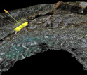
Running for more than 1,000 kilometers along picturesque coastline, California's Highway 1 is easy prey for many of the natural hazards plaguing the region, including landslides. The California Department of Transportation (Caltrans) is currently building a kilometer-long tunnel to bypass one of the most landslide-prone stretches of the highway, the Devil's Slide, to help ensure drivers' safe passage. Using a new software package developed by researchers at Virginia Tech in Blacksburg, Va., project engineers are getting a detailed 3-D view of the rock exposed in the excavation, adding a new tool for improving both safety and construction progress. Developed as part of a National Science Foundation Information Technology Research Initiative (ITR) project, the software, called "geotechnical Visualization Tool" (gVT), converts imagery of millions of rock-surface points--collected at a safe distance by a laser scanner--into an easily manipulated web of information. The data become a permanent digital record of the newly exposed material. The scan data, at a resolution of 5 millimeters, provides information that the software program packages into enormous visualizations incorporating up to 10 meters of excavated tunnel. Engineers then use gVT to spot potential hazards to both the tunnel and the construction crews before weaknesses in the rock have a chance to trigger a collapse. The information is so detailed that researchers can observe where rock layers are separating and how fractures are oriented. Researchers can even recreate sections of rock after they have fallen, providing a critical asset for determining where and how to safely drill. Because the data is portable, engineers can conduct all of the analyses from their home base at any time, far from the danger of the tunnel. "Geologic maps have traditionally been made using manual measurements taken by geologists directly on the rock," said Joseph Dove, the lead developer of gVT at Virginia Tech and co-PI on the ITR project. "Laser scanning is revolutionary for underground mapping because it allows direct collection of digital data in three dimensions at high resolution." After a careful analysis of the scanned data, the engineers can take manual follow-up measurements to confirm their results. "These 3-D visualizations enhance geological documentation and an engineer's ability to make decisions," added Jeramy Decker, a Ph.D. graduate of Virginia Tech and co-developer of gVT, now at Kiewitt Pacific Company, the construction contractor excavating the tunnels. In use as part of a suite of private industry engineering tools and software critical to the tunneling beneath Devil's Slide, gVT is the product of a two-year collaboration between civil engineers and computer scientists. The Devil's Slide application is the first use of gVT in a true construction environment. Decker presented the new technique in a talk at the 42nd U.S.-Canada Rock Mechanics Symposium in San Francisco on June 29th.
-NSF-

Media Contacts
Joshua A. Chamot, NSF (703) 292-7730 jchamot@nsf.gov
Christina Daniilidi, Virginia Tech (540) 231-1168 danii@vt.edu
Program Contacts
Richard J. Fragaszy, NSF (703) 292-7011 rfragasz@nsf.gov
Principal Investigators
Joseph Dove, Virginia Tech (540) 231-2307 jedove@vt.edu
Co-Investigators
Jeramy Decker, Kiewit Pacific Corporation (510) 274-8873 Jeramy.decker@kiewit.com
The National Science Foundation (NSF) is an independent federal agency that supports fundamental research and education across all fields of science and engineering. In fiscal year (FY) 2009, its budget is $9.5 billion, which includes $3.0 billion provided through the American Recovery and Reinvestment Act. NSF funds reach all 50 states through grants to over 1,900 universities and institutions. Each year, NSF receives about 44,400 competitive requests for funding, and makes over 11,500 new funding awards. NSF also awards over $400 million in professional and service contracts yearly.
 Get News Updates by Email Get News Updates by Email
Useful NSF Web Sites:
NSF Home Page: http://www.nsf.gov
NSF News: http://www.nsf.gov/news/
For the News Media: http://www.nsf.gov/news/newsroom.jsp
Science and Engineering Statistics: http://www.nsf.gov/statistics/
Awards Searches: http://www.nsf.gov/awardsearch/
|