|

Press Release 06-107
Rise in Sea Level, Loss of Wetlands May Account for Unstable Ground in Mississippi Delta

Basement layers remain unchanged for thousands of years
July 21, 2006
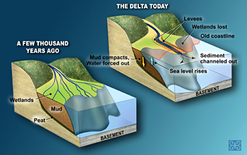
While erosion and wetland loss have become huge problems along Louisiana's coast, the land 30 to 50 feet beneath much of the Mississippi Delta has been very stable for the past 8,000 years, with low to nonexistent subsidence rates. So say geoscientists from Tulane University and Utrecht University in the Netherlands, challenging the notion that subsidence, or sinking of the earth, bears much of the blame for Louisiana's coastal geology problems.
A research team led by Tulane's Torbjörn Törnqvist suggests instead that compaction of the shallowest and most-recently formed delta sediments is the main cause of subsidence in that area.
"Our research could have major implications for rebuilding plans that are currently being debated," said Tornqvist. "Over the long term, comprehensive understanding of subsidence will better support rational coastal management and successful urban and land-use planning for all low-lying areas along the Gulf Coast."
Their findings were published online on Fri., July 21, 2006, in the journal Geology, published by the Geological Society of America.
Törnqvist and his team reconstructed the rate of sea-level rise over the past 8,000 years from three separate areas in the Mississippi Delta. Peat samples were used as sea-level indicators because peat forms as soon as water levels rise above the land surface.
"If we are to reverse the loss of Louisiana wetlands and the protection they afford New Orleans, we need to think outside the box," said H. Richard Lane, program director in the National Science Foundation's Division of Earth Sciences, which funded the research. "Innovative research such as this opens up new possibilities for addressing environmental issues."
According to Törnqvist, rapid subsidence of coastal Louisiana is well documented but not well understood. Leading candidates include:
- Long-term subsidence and faulting of the Earth's crust caused by rapidly accumulating sediments in the Mississippi Delta
- Compaction of relatively shallow and water-rich deposits formed during the past 10,000 years
- Withdrawal of oil, gas and groundwater from the subsurface
The role of tectonic processes and their relationship to sea-level rise, coastal erosion and wetland loss have received considerable attention from researchers. But, "if that were the whole story, there would be major consequences for Louisiana, because subsidence of Earth's crust is a natural process that remains beyond human control," said Törnqvist.
Carbon isotope analyses verified that rise in sea level directly controlled accumulation of sediment. Elevation of sampling sites was determined by a combination of GPS measurements and optical surveying. The team then compared its results with sea-level data from the same time period from areas in the Caribbean regarded as tectonically stable, including Florida and the Bahamas.
The geologists were surprised to find no difference, suggesting that large portions of the Mississippi Delta's basement land is stable. They also inferred from the data that long-term subsidence rates are a fraction of a millimeter per year rather than 10 millimeters, as had been thought.
Törnqvist points out that these numbers do not necessarily apply to the entire delta. He also notes that well-documented high-subsidence rates in and near the lower "bird foot" of the delta--so named because the waterways form the shape of a bird's foot--indicate that different conditions prevail there.
"It remains to be demonstrated how rapidly the basement under metropolitan New Orleans subsides," he said.
-NSF-

Media Contacts
Cheryl Dybas, NSF (703) 292-7734 cdybas@nsf.gov
Peter West, NSF (703) 292-7761 pwest@nsf.gov
Ann Cairns, GSA/Geology (301) 357-1056 acairns@geosociety.org
Mike Strecker, Tulane University (504) 865-5210 mstreck@tulane.edu
The National Science Foundation (NSF) is an independent federal agency that supports fundamental research and education across all fields of science and engineering. In fiscal year (FY) 2009, its budget is $9.5 billion, which includes $3.0 billion provided through the American Recovery and Reinvestment Act. NSF funds reach all 50 states through grants to over 1,900 universities and institutions. Each year, NSF receives about 44,400 competitive requests for funding, and makes over 11,500 new funding awards. NSF also awards over $400 million in professional and service contracts yearly.
 Get News Updates by Email Get News Updates by Email
Useful NSF Web Sites:
NSF Home Page: http://www.nsf.gov
NSF News: http://www.nsf.gov/news/
For the News Media: http://www.nsf.gov/news/newsroom.jsp
Science and Engineering Statistics: http://www.nsf.gov/statistics/
Awards Searches: http://www.nsf.gov/awardsearch/
|