|

Press Release 05-035
New Technique Uses Seismic 'Garbage' to View Earth's Interior

Frees seismologists from 'tyranny' of waiting for earthquakes
March 10, 2005
Seismologists have long relied on earthquakes or expensive tools like explosives to help create images of Earth’s interior, but a new method created by University of Colorado at Boulder (CU-Boulder) researchers will produce quicker, cheaper and clearer images.
Rather than waiting for earthquakes, the researchers have recovered surface-wave information from normal seismic noise that is constantly produced by fluctuations in the Earth’s atmosphere and oceans. Measuring surface waves is important because the information helps scientists get a clearer picture of the Earth’s interior, according to Michael Ritzwoller, director of CU-Boulder’s Center for Imaging the Earth’s Interior.
The method is described in the March 11 issue of the journal Science.
“This new technique will give us a better fundamental understanding of the planet by providing much better resolution of Earth’s interior,” Ritzwoller said. “It also will diminish what is known in seismology as the ‘tyranny of earthquakes,’ which means having to wait for an earthquake to happen to do our jobs."
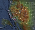
The new method promises significant improvements in the resolution and accuracy of crust and upper mantle images down to 60 miles or more within the Earth, particularly when used with seismic projects like USArray, according to Nikolai Shapiro, a research associate in the Center for Imaging the Earth’s Interior and the study’s chief author.
Coupled with existing and emerging technology, such as USArray, the new measuring technique will lead to a better fundamental understanding of the structure of the planet and may help save lives in the process, Ritzwoller said. A component of the National Science Foundation's (NSF) EarthScope program, USArray includes hundreds of portable seismometers that in coming years will be moved over the entire country, producing images of the Earth’s interior to aid in earthquake risk assessment.
"The authors' application of what used to be 'seismic noise' to the detailed mapping of the crust and upper mantle will have significant impact on earth science and on seismic hazard mitigation," says James Whitcomb, head of NSF's deep earth processes section, which funded the research. "This innovative research foretells what's to come from EarthScope."
Researchers have for years been constructing tomographic images of Earth’s crust and upper mantle from waves generated by earthquakes. That method, known as seismic tomography, reconstructs Earth’s inner structure on a computer screen, slice by slice. The new technique is similar, but is based on organizing ambient seismic noise, which is typically discarded as seismic "garbage."
Seismic tomography is like doing a medical CT scan of the Earth, Ritzwoller said. But when people have a CT scan, doctors are in control and can make images at will. Seismologists can’t control when an earthquake happens, so they can either wait for another one or set off explosives to create their own image-generating waves.
“To move beyond these limitations requires observational methods based on seismic sources other than earthquakes, which is what our method offers,” said Shapiro.
-NSF-

Media Contacts
Cheryl L. Dybas, NSF (703) 292-7734 cdybas@nsf.gov
Jim Scott, University of Colorado at Boulder (303) 492-3114 jim.scott@colorado.edu
The National Science Foundation (NSF) is an independent federal agency that supports fundamental research and education across all fields of science and engineering. In fiscal year (FY) 2009, its budget is $9.5 billion, which includes $3.0 billion provided through the American Recovery and Reinvestment Act. NSF funds reach all 50 states through grants to over 1,900 universities and institutions. Each year, NSF receives about 44,400 competitive requests for funding, and makes over 11,500 new funding awards. NSF also awards over $400 million in professional and service contracts yearly.
 Get News Updates by Email Get News Updates by Email
Useful NSF Web Sites:
NSF Home Page: http://www.nsf.gov
NSF News: http://www.nsf.gov/news/
For the News Media: http://www.nsf.gov/news/newsroom.jsp
Science and Engineering Statistics: http://www.nsf.gov/statistics/
Awards Searches: http://www.nsf.gov/awardsearch/
|