
 Feeds & Data
Magnitude 6.4 - EASTERN XIZANG
2008 October 06 08:30:45 UTC
Earthquake Details
| Magnitude | 6.4 |
|---|---|
| Date-Time |
|
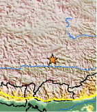
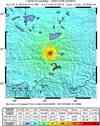
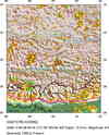
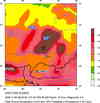
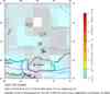
| Location | 29.761°N, 90.320°E |
| Depth | 12 km (7.5 miles) set by location program |
| Region | EASTERN XIZANG |
| Distances | 75 km (45 miles) WNW of Lhasa, Xizang (Tibet) 155 km (95 miles) ENE of Xigaze, Xizang (Tibet) 265 km (165 miles) NNE of THIMPHU, Bhutan 2625 km (1630 miles) WSW of BEIJING, Beijing, China |
| Location Uncertainty | horizontal +/- 4.9 km (3.0 miles); depth fixed by location program |
| Parameters | NST=195, Nph=195, Dmin=>999 km, Rmss=1.03 sec, Gp= 36°, M-type=regional moment magnitude (Mw), Version=R |
| Source |
|
| Event ID | us2008xva9 |
- This event has been reviewed by a seismologist.
- Did you feel it? Report shaking and damage at your location. You can also view a map displaying accumulated data from your report and others.
Earthquake Summary

Felt Reports
Nine people killed and at least 19 injured. Many houses in Damxung collapsed. Felt (IV) at Lhasa. Also felt at Thimphu, Bhutan.
Tectonic Summary
The eastern Xizang earthquake of October 6, 2008 occurred as a result of normal faulting in the Tibetan Plateau. The style of faulting is inferred from the characteristics of seismic waves radiated by the earthquake source. The faulting that caused the earthquake is a consequence of predominantly east-west oriented extensional stress that ultimately arises from the convergence of the India plate northwards with respect to the Eurasia plate at a rate of over 40 mm/yr. This convergence drives the uplift of the Himalaya Mountains and Tibetan Plateau and produces generally north-south compressional stresses on the north and south margins of the plateau. The plateau interior is spreading to the east and, as a result, is an area of east-west extension within the larger region of north-south compression. The epicentral region of the 2008 earthquake previously experienced a magnitude 6.1 normal faulting earthquake on July 30, 1992
Earthquake Maps

Scientific & Technical Information

- Preliminary Earthquake Report
- U.S. Geological Survey, National Earthquake Information Center:
World Data Center for Seismology, Denver
