
 Feeds & Data
Magnitude 6.6 - ANDREANOF ISLANDS, ALEUTIAN IS., ALASKA
2008 April 16 05:54:19 UTC
Earthquake Details
| Magnitude | 6.6 |
|---|---|
| Date-Time |
|
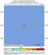
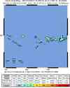
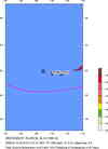
| Location | 51.889°N, 179.189°W |
| Depth | 13 km (8.1 miles) set by location program |
| Region | ANDREANOF ISLANDS, ALEUTIAN IS., ALASKA |
| Distances |
|
| Location Uncertainty | horizontal +/- 3.7 km (2.3 miles); depth fixed by location program |
| Parameters | NST=310, Nph=310, Dmin=172.6 km, Rmss=0.89 sec, Gp= 25°, M-type=centroid moment magnitude (Mw), Version=Q |
| Source |
|
| Event ID | us2008qxam |
- This event has been reviewed by a seismologist.
- Did you feel it? Report shaking and damage at your location. You can also view a map displaying accumulated data from your report and others.
Earthquake Summary


The following is a release by the United States Geological Survey, National Earthquake Information Center: An earthquake occurred 70 km (40 miles) W of Tanaga Volcano, Alaska, 75 km (45 miles) N of Amatignak Island, Alaska, 2055 km (1270 miles) WSW of Anchorage, Alaska at 10:54 PM MST, Apr 15, 2008 (7:54 PM AHST in Aleutian Islands). The magnitude and location may be revised when additional data and further analysis results are available. This earthquake is located in a remote area and no damage or casualties are expected.
Felt Reports
Felt at Adak.
Earthquake Maps


Scientific & Technical Information

Additional Information, News Reports
- Preliminary Earthquake Report
- U.S. Geological Survey, National Earthquake Information Center:
World Data Center for Seismology, Denver
