
 Feeds & Data
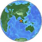
Magnitude 7.4 - SIMEULUE, INDONESIA
2008 February 20 08:08:32 UTC
Earthquake Details
| Magnitude | 7.4 |
|---|---|
| Date-Time |
|
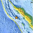
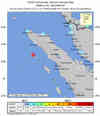
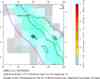
| Location | 2.778°N, 95.978°E |
| Depth | 35 km (21.7 miles) set by location program |
| Region | SIMEULUE, INDONESIA |
| Distances | 310 km (190 miles) SSE of Banda Aceh, Sumatra, Indonesia 310 km (195 miles) WSW of Medan, Sumatra, Indonesia 335 km (210 miles) WNW of Sibolga, Sumatra, Indonesia 1545 km (960 miles) NW of JAKARTA, Java, Indonesia |
| Location Uncertainty | horizontal +/- 5.5 km (3.4 miles); depth fixed by location program |
| Parameters | NST=233, Nph=233, Dmin=588 km, Rmss=0.97 sec, Gp= 32°, M-type=moment magnitude (Mw), Version=8 |
| Source |
|
| Event ID | us2008nran |
- This event has been reviewed by a seismologist.
- Did you feel it? Report shaking and damage at your location. You can also view a map displaying accumulated data from your report and others.
Earthquake Summary
The following is a release by the United States Geological Survey, National Earthquake Information Center: An earthquake occurred 310 km (195 miles) SSE of Banda Aceh, Sumatra, Indonesia, 310 km (195 miles) WSW of Medan, Sumatra, Indonesia, 335 km (210 miles) WNW of Sibolga, Sumatra, Indonesia, 1545 km (960 miles) NW of JAKARTA, Java, Indonesia at 1:08 AM MST, Feb 20, 2008 (3:08 PM local time in Indonesia). The magnitude and location may be revised when additional data and further analysis results are available. Earthquakes of this type sometimes cause tsunamis, however the USGS has no information that an actual tsunami has been generated. For information about tsunamis, contact the NOAA Tsunami Warning Centers at http://tsunami.gov.
Felt Reports
Three people killed and 25 seriously injured in the western Aceh province. Felt (V) at Meulaboh; (IV) at Banda Aceh, Medan and Tapaktuan; (III) at Gunungsitoli, Padang and Sibolga; (II) at Payakumbuh and Bukittinggi. Also felt at Duri and Lhokseumawe. Felt (III) at Butterworth, Gelugor, George Town, Kuala Lumpur, Petaling Jaya, Sungai Ara and Tanjong Tokong and (II) at Perai. Also felt at Alor Setar, Ayer Itam, Juru, Kajang-Sungai Chua, Kampong Tanjong Bunga, Kampong Tanjung Karang, Klang, Kota Baharu, Kuah, Kulim, Nibung Tepal and Shah Alam, Malaysia. Also felt at Kathu, Thailand.
Tectonic Summary
The magnitude 7.4 Simeulue, Indonesia earthquake of February 20, 2008 occurred as the result of thrust faulting on the boundary between the Australia and Sunda plates. At the location of this earthquake, the Australia plate moves north-northeast with respect to the Sunda plate at a velocity of about 55 mm/year. The direction of relative plate motion is oblique to the orientation of the plate boundary offshore of the west coast of Sumatra. The component of plate-motion perpendicular to the boundary is accommodated by thrust faulting on the offshore plate-boundary, with the Australia plate subducting beneath the Sunda plate. Much of the component of plate motion parallel to the plate boundary is accommodated by strike-skip faulting on the Sumatra fault, which is inland on Sumatra proper.
This earthquake occurred at the south end of the rupture zone of the great magnitude 9.1 earthquake of December 26, 2004 and at the north end of the rupture zone of the magnitude 8.6 Nias Island earthquake of March 28, 2005, where the 2004 and 2005 rupture zones nearly abut. The earthquake of December 26, 2004, produced the devastating Indian Ocean tsunami of that date. Since 2000, much of the Sunda trench between the northern Andaman Islands to Eggano Island, a distance of more than 2,000 km, has ruptured in a series of large subduction zone earthquakes.
Earthquake Information for Asia
Earthquake Information for Indonesia
 Tsunami Information
- NOAA West Coast & Alaska Tsunami Warning Center
- NOAA Pacific Tsunami Warning Center
- Tsunami Information Links
The earthquake locations and magnitudes cited in these NOAA tsunami bulletins are very preliminary and may be superceded by USGS locations and magnitudes computed using more extensive data sets.
Earthquake Maps


Scientific & Technical Information

- Preliminary Earthquake Report
- U.S. Geological Survey, National Earthquake Information Center:
World Data Center for Seismology, Denver
