
 Feeds & Data
Magnitude 5.9 - LAC KIVU REGION, DEM. REP. OF THE CONGO
2008 February 03 07:34:12 UTC
Earthquake Details
| Magnitude | 5.9 |
|---|---|
| Date-Time |
|
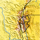
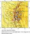
| Location | 2.318°S, 28.945°E |
| Depth | 10 km (6.2 miles) set by location program |
| Region | LAC KIVU REGION, DEM. REP. OF THE CONGO |
| Distances | 25 km (15 miles) NNE of Bukavu, Dem. Republic of the Congo 75 km (50 miles) SSW of Goma, Dem. Republic of the Congo 885 km (550 miles) W of NAIROBI, Kenya 1530 km (950 miles) E of KINSHASA, Dem. Republic of the Congo |
| Location Uncertainty | horizontal +/- 5.7 km (3.5 miles); depth fixed by location program |
| Parameters | NST=137, Nph=137, Dmin=>999 km, Rmss=0.81 sec, Gp= 32°, M-type=moment magnitude (Mw), Version=R |
| Source |
|
| Event ID | us2008mzam |
- This event has been reviewed by a seismologist.
- Did you feel it? Report shaking and damage at your location. You can also view a map displaying accumulated data from your report and others.
Earthquake Summary

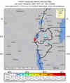
Felt Reports
Seven people killed, 447 injured, 1,087 houses destroyed and 2,378 buildings damaged at Bukavu. Power outages occurred in about 50 percent of the city. Thirty-seven people killed, 643 injured, 1,201 houses destroyed and 24 buildings damaged in the Cyangugu-Nyamasheke area, Rwanda. Felt (IV) at Butare and Kigali. Also felt at Bujumbura and Kirundo, Burundi; Kabanga and Rulenge, Tanzania; and Kabale, Uganda.
Tectonic Summary
The earthquake occurred in the Western Rift of the East African rift system. The East African rift system is a diffuse, approximately 3000-km-long, zone of crustal extension that passes through eastern Africa from Djibouti and Eritrea on the north to Malawi on the south and that constitutes the boundary between the Africa plate on the west and the Somalia plate on the east. At the earthquake's latitude, the Africa and Somalia plates are spreading apart at a rate of about four millimeters per year. The earthquake occurred near Lake Kivu, the basin of which was created by normal faulting similar to that which produced the February 3 earthquake. The largest earthquake to have occurred in the rift system since 1900 had a magnitude of about 7.6. The epicenter of the February 3, 2008, earthquake is within several tens of kilometers of the epicenter of a magnitude 6.2 earthquake that killed two people in Goma in October 2002. Earthquakes within the East African rift system occur as the result of both normal faulting and strike-slip faulting.
Earthquake Maps


Scientific & Technical Information

- Preliminary Earthquake Report
- U.S. Geological Survey, National Earthquake Information Center:
World Data Center for Seismology, Denver
