
 Feeds & Data
Magnitude 6.7 - ANTOFAGASTA, CHILE
2007 December 16 08:09:19 UTC
Earthquake Details
| Magnitude | 6.7 |
|---|---|
| Date-Time |
|
| Location | 22.914°S, 70.060°W |
| Depth | 57.8 km (35.9 miles) set by location program |
| Region | ANTOFAGASTA, CHILE |
| Distances | 90 km (55 miles) NNE of Antofagasta, Chile 95 km (60 miles) S of Tocopilla, Chile 125 km (80 miles) WSW of Calama, Chile 1170 km (730 miles) N of SANTIAGO, Chile |
| Location Uncertainty | horizontal +/- 6 km (3.7 miles); depth fixed by location program |
| Parameters | NST=264, Nph=264, Dmin=122.5 km, Rmss=0.98 sec, Gp= 36°, M-type=moment magnitude (Mw), Version=R |
| Source |
|
| Event ID | us2007kzaf |
- This event has been reviewed by a seismologist.
- Did you feel it? Report shaking and damage at your location. You can also view a map displaying accumulated data from your report and others.
Earthquake Summary


The following is a release by the United States Geological Survey, National Earthquake Information Center: An earthquake occurred 55 km (35 miles) SSE of Tocopilla, Chile, 110 km (65 miles) W of Calama, Chile, 130 km (80 miles) NNE of Antofagasta, Chile, 1215 km (750 miles) N of SANTIAGO, Chile at 1:09 AM MST, Dec 16, 2007 (5:09 AM local time in Antofagasta, Chile). The magnitude and location may be revised when additional data and further analysis results are available. No reports of damage or casualties have been received at this time.
Felt Reports
Felt (VI) at Baquedano, Maria Elena, Mejillones, Sierra Gorda and Tocopilla; (V) at Antofagasta, Calama, Iquique and San Pedro de Atacama; (IV) at Alto Hospicio, Huara, Pica, Pozo Almonte and Taltal. Also felt at Arica. Disrupted power and telecommunications throughout the epicentral area from Antofagasta to Iquique.
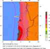
Earthquake Maps


Scientific & Technical Information

- Preliminary Earthquake Report
- U.S. Geological Survey, National Earthquake Information Center:
World Data Center for Seismology, Denver
