
 Feeds & Data
Magnitude 6.7 - NEAR THE COAST OF CENTRAL PERU
2006 October 20 10:48:57 UTC
Earthquake Details
| Magnitude | 6.7 |
|---|---|
| Date-Time |
= Coordinated Universal Time = local time at epicenter |
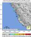
| Location | 13.441°S, 76.577°W |
| Depth | 32.2 km (20.0 miles) set by location program |
| Region | NEAR THE COAST OF CENTRAL PERU |
| Distances | 65 km (40 miles) W of Chincha Alta, Peru 115 km (75 miles) WNW of Ica, Peru 155 km (95 miles) SSE of LIMA, Peru 225 km (140 miles) SW of Huancayo, Peru |
| Location Uncertainty | horizontal +/- 6.3 km (3.9 miles); depth fixed by location program |
| Parameters | Nst=214, Nph=214, Dmin=>999 km, Rmss=0.94 sec, Gp= 68°, M-type=teleseismic moment magnitude (Mw), Version=Q |
| Source | USGS NEIC (WDCS-D) |
| Event ID | usubal |
- This event has been reviewed by a seismologist.
Did you feel it?
Report shaking and damage at your location. You can also view a map displaying accumulated data from your report and others.
Earthquake Summary


Felt Reports
Minor damage (IV) to some houses at Pisco. Felt (IV) at Chincha. Felt at Lima.
Earthquake Maps
Earthquake Location
Location Maps
Did You Feel It?
Tell Us

ShakeMap

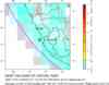
Historical Seismicity

Seismic Hazard Map
EQ Density Map

Google Map

 Historic Moment Tensor Solutions
- Preliminary Earthquake Report
- U.S. Geological Survey, National Earthquake Information Center
World Data Center for Seismology, Denver
