
 Feeds & Data
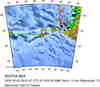
Magnitude 7.0 - SCOTIA SEA
2006 August 20 03:41:47 UTC
Earthquake Details
| Magnitude | 7.0 |
|---|---|
| Date-Time |
= Coordinated Universal Time = local time at epicenter |
| Location | 61.006°S, 34.391°W |
| Depth | 10 km (6.2 miles) set by location program |
| Region | SCOTIA SEA |
| Distances | 495 km (305 miles) WSW of Bristol Island, South Sandwich Islands 630 km (390 miles) SW of Visokoi Island, South Sandwich Islands 680 km (420 miles) E of Coronation Island, South Orkney Islands 3240 km (2010 miles) N of South Pole, Antarctica |
| Location Uncertainty | horizontal +/- 5.5 km (3.4 miles); depth fixed by location program |
| Parameters | Nst=219, Nph=219, Dmin=759.4 km, Rmss=0.83 sec, Gp= 29°, M-type=teleseismic moment magnitude (Mw), Version=9 |
| Source | USGS NEIC (WDCS-D) |
| Event ID | usrqal |
- This event has been reviewed by a seismologist.
Did you feel it?
Report shaking and damage at your location. You can also view a map displaying accumulated data from your report and others.
Earthquake Summary


Earthquake Maps
Earthquake Location
Location Maps

Did You Feel It?
Tell Us

ShakeMap
Historical Seismicity

EQ Density Map

Google Map

 Historic Moment Tensor Solutions
- Preliminary Earthquake Report
- U.S. Geological Survey, National Earthquake Information Center
World Data Center for Seismology, Denver
